Premium Framed Print > Arts > Artists > S > Walter Smalling
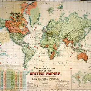
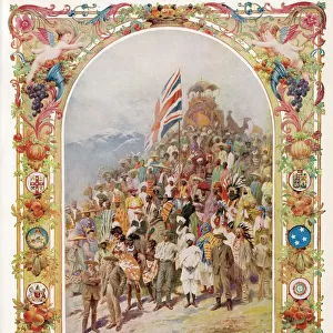
Premium Framed Print : MAP: BRITISH EMPIRE, 1886. Map, 1886, of the British Empire by Walter Crane


Framed Photos from Granger
MAP: BRITISH EMPIRE, 1886. Map, 1886, of the British Empire by Walter Crane
MAP: BRITISH EMPIRE, 1886. Map, 1886, of the British Empire by Walter Crane. The small insert shows, in red, the extent of the British territories in 1786
Granger holds millions of images spanning more than 25,000 years of world history, from before the Stone Age to the dawn of the Space Age
Media ID 6620137
1886 Arts And Crafts Movement British Empire Colonialism Crane Walter World
14"x16" Premium Frame
Contemporary style Premium Wooden Frame with 8"x10" Print. Complete with 2" White Mat and 1.25" thick MDF frame. Printed on 260 gsm premium paper. Glazed with shatter proof UV coated acrylic glass. Backing is paper covered backing with rubber bumpers. Supplied ready to hang with a pre-installed sawtooth/wire hanger. Care Instructions: Spot clean with a damp cloth. Securely packaged in a clear plastic bag and envelope in a reinforced cardboard shipper
FSC Real Wood Frame and Double Mounted with White Conservation Mountboard - Professionally Made and Ready to Hang
Estimated Image Size (if not cropped) is 25.4cm x 20.3cm (10" x 8")
Estimated Product Size is 40.6cm x 35.6cm (16" x 14")
These are individually made so all sizes are approximate
Artwork printed orientated as per the preview above, with landscape (horizontal) orientation to match the source image.
FEATURES IN THESE COLLECTIONS
> Granger Art on Demand
> Maps
> Arts
> Artists
> C
> Walter Crane
> Arts
> Artists
> S
> Walter Smalling
> Maps and Charts
> British Empire Maps
> Maps and Charts
> Popular Maps
> Maps and Charts
> Related Images
> Maps and Charts
> World
EDITORS COMMENTS
This print showcases a historical map of the British Empire in 1886, masterfully created by Walter Crane. The intricate details and vibrant colors bring to life the vast expanse of territories under British rule during this era. As one explores the map, it becomes evident that the empire spanned across continents and oceans, leaving an indelible mark on world history. Walter Crane's artistic prowess is evident in this piece as he skillfully captures not only geographical accuracy but also conveys a sense of grandeur and power associated with colonialism. The inclusion of a small insert highlighting the extent of British territories in 1786 adds depth to our understanding of how much the empire expanded over time. This artwork serves as a poignant reminder of the late colonial period when Britain held significant global influence. It encapsulates an important chapter in world history, shedding light on both the achievements and controversies surrounding imperialism. As part of the Arts and Crafts movement, Walter Crane's work embodies his commitment to combining aesthetics with social commentary. This particular map print stands as a testament to his talent for merging artistry with education. The Granger Collection has once again curated an exceptional piece that invites viewers to delve into history through visual storytelling. Whether displayed at home or in educational settings, this print is sure to spark curiosity and ignite conversations about past empires' legacies.
MADE IN THE USA
Safe Shipping with 30 Day Money Back Guarantee
FREE PERSONALISATION*
We are proud to offer a range of customisation features including Personalised Captions, Color Filters and Picture Zoom Tools
SECURE PAYMENTS
We happily accept a wide range of payment options so you can pay for the things you need in the way that is most convenient for you
* Options may vary by product and licensing agreement. Zoomed Pictures can be adjusted in the Cart.