Metal Print > Europe > France > Paris > Maps
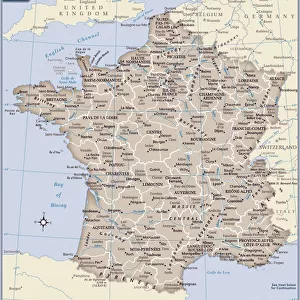
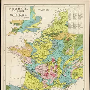
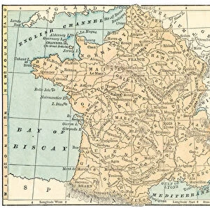
Metal Print : MAP OF FRANCE, c1900. With inset detail of Paris and surrounding area


![]()
Metal Prints from Granger
MAP OF FRANCE, c1900. With inset detail of Paris and surrounding area
Granger holds millions of images spanning more than 25,000 years of world history, from before the Stone Age to the dawn of the Space Age
Media ID 6622393
16"x20" (51x41cm) Metal Print
Discover the rich history and culture of France with our stunning Metal Prints featuring a vintage map of France from c1900. This intricately detailed map, sourced from The Granger Collection through Granger Art on Demand, showcases the beauty and complexity of the European country. The inset detail of Paris and its surrounding area provides a captivating glimpse into the heart of the City of Light. Our high-quality Metal Prints bring vibrant colors and sharp details to your space, making it an exquisite addition to any home or office decor. Transport yourself back in time and explore the history of France with this beautiful and functional piece of art.
Made with durable metal and luxurious printing techniques, our metal photo prints go beyond traditional canvases, adding a cool, modern touch to your space. Wall mount on back. Eco-friendly 100% post-consumer recycled ChromaLuxe aluminum surface. The thickness of the print is 0.045". Featuring a Scratch-resistant surface and Rounded corners. Backing hangers are attached to the back of the print and float the print 1/2-inch off the wall when hung, the choice of hanger may vary depending on size and International orders will come with Float Mount hangers only. Finished with a brilliant white high gloss surface for unsurpassed detail and vibrance. Printed using Dye-Sublimation and for best care we recommend a non-ammonia glass cleaner, water, or isopropyl (rubbing) alcohol to prevent harming the print surface. We recommend using a clean, lint-free cloth to wipe off the print. The ultra-hard surface is scratch-resistant, waterproof and weatherproof. Avoid direct sunlight exposure.
Made with durable metal and luxurious printing techniques, metal prints bring images to life and add a modern touch to any space
Estimated Image Size (if not cropped) is 50.8cm x 40.6cm (20" x 16")
Estimated Product Size is 51.4cm x 41.2cm (20.2" x 16.2")
These are individually made so all sizes are approximate
Artwork printed orientated as per the preview above, with landscape (horizontal) orientation to match the source image.
FEATURES IN THESE COLLECTIONS
> Granger Art on Demand
> Maps
> Arts
> Landscape paintings
> Waterfall and river artworks
> River artworks
> Europe
> France
> Paris
> Maps
> Europe
> France
> Paris
> Related Images
> Maps and Charts
> Early Maps
> Maps and Charts
> Related Images
EDITORS COMMENTS
This print from Granger Art on Demand showcases a vintage "Map of France, c1900". With its intricate details and historical significance, this piece takes us back in time to the early 20th century. The map features an inset detail of Paris and its surrounding area, allowing us to explore the enchanting capital city's layout during that era. The craftsmanship evident in this French map is truly remarkable. Every river, town, and border is meticulously illustrated with precision and accuracy. It serves as a testament to the cartographic expertise of the time and provides valuable insights into France's geographical landscape at the turn of the century. As we gaze upon this beautiful artwork, our imagination runs wild with thoughts of exploration and adventure. We can almost envision travelers relying on maps like these to navigate their way through picturesque countryside or bustling city streets. This particular map holds immense historical value as it captures a snapshot of France during an important period in its history. "The Map of France, c1900" by The Granger Collection invites us to appreciate both its aesthetic appeal and educational significance. Whether you are a lover of history or simply intrigued by antique maps, this print will undoubtedly add charm and sophistication to any space it graces.
MADE IN THE USA
Safe Shipping with 30 Day Money Back Guarantee
FREE PERSONALISATION*
We are proud to offer a range of customisation features including Personalised Captions, Color Filters and Picture Zoom Tools
SECURE PAYMENTS
We happily accept a wide range of payment options so you can pay for the things you need in the way that is most convenient for you
* Options may vary by product and licensing agreement. Zoomed Pictures can be adjusted in the Cart.