Metal Print > Granger Art on Demand > Maps
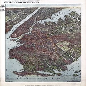
Metal Print : MAP: JAMAICA, 1763. British map of the island of Jamaica, published 1763


![]()
Metal Prints from Granger
MAP: JAMAICA, 1763. British map of the island of Jamaica, published 1763
MAP: JAMAICA, 1763.
British map of the island of Jamaica, published 1763
Granger holds millions of images spanning more than 25,000 years of world history, from before the Stone Age to the dawn of the Space Age
Media ID 12321400
16"x20" (51x41cm) Metal Print
Discover the rich history of Jamaica with our stunning Metal Print of the British map published by Granger in 1763. This intricately detailed and historically significant map of the island, from The Granger Collection, comes to life with our high-quality Metal Print. The vibrant colors and sharp lines pop against the sleek, modern metal surface, making it a captivating addition to any room. Travel back in time and explore the historical landmarks and geographical features of Jamaica with this beautiful and unique piece of art. Order now and bring a piece of history into your home or office.
Made with durable metal and luxurious printing techniques, our metal photo prints go beyond traditional canvases, adding a cool, modern touch to your space. Wall mount on back. Eco-friendly 100% post-consumer recycled ChromaLuxe aluminum surface. The thickness of the print is 0.045". Featuring a Scratch-resistant surface and Rounded corners. Backing hangers are attached to the back of the print and float the print 1/2-inch off the wall when hung, the choice of hanger may vary depending on size and International orders will come with Float Mount hangers only. Finished with a brilliant white high gloss surface for unsurpassed detail and vibrance. Printed using Dye-Sublimation and for best care we recommend a non-ammonia glass cleaner, water, or isopropyl (rubbing) alcohol to prevent harming the print surface. We recommend using a clean, lint-free cloth to wipe off the print. The ultra-hard surface is scratch-resistant, waterproof and weatherproof. Avoid direct sunlight exposure.
Made with durable metal and luxurious printing techniques, metal prints bring images to life and add a modern touch to any space
Estimated Image Size (if not cropped) is 50.8cm x 40.6cm (20" x 16")
Estimated Product Size is 51.4cm x 41.2cm (20.2" x 16.2")
These are individually made so all sizes are approximate
Artwork printed orientated as per the preview above, with landscape (horizontal) orientation to match the source image.
EDITORS COMMENTS
This print showcases a historical artifact that takes us back to the year 1763, when the British map of Jamaica was published. The intricate details and sepia tones evoke a sense of nostalgia, transporting us to an era long gone. As we gaze upon this piece, we are reminded of the significance and influence that maps hold in shaping our understanding of the world. The map itself is a testament to the meticulous craftsmanship and dedication put forth by its creators. Every contour line, river bend, and coastline has been carefully etched onto parchment paper, capturing the essence of Jamaica's geography with remarkable precision. The text accompanying this masterpiece provides valuable insights into the island's history during that time period. Through this image, we are invited to explore not only Jamaica's physical landscape but also its cultural heritage as seen through colonial British eyes. It serves as a reminder of how cartography can be both informative and subjective - reflecting not only geographical features but also political boundaries and power dynamics. Granger Art on Demand presents us with yet another gem from their extensive collection: an extraordinary visual representation that sparks curiosity about our past while celebrating human ingenuity in mapping out our world.
MADE IN THE USA
Safe Shipping with 30 Day Money Back Guarantee
FREE PERSONALISATION*
We are proud to offer a range of customisation features including Personalised Captions, Color Filters and Picture Zoom Tools
SECURE PAYMENTS
We happily accept a wide range of payment options so you can pay for the things you need in the way that is most convenient for you
* Options may vary by product and licensing agreement. Zoomed Pictures can be adjusted in the Cart.