Metal Print > Europe > Netherlands > Leiden
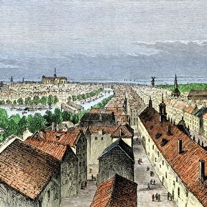
Metal Print : Map of Rijnland and Amstelland, c.1675. Creator: Workshop of Nicolaes Visscher


![]()
Metal Prints from Heritage Images
Map of Rijnland and Amstelland, c.1675. Creator: Workshop of Nicolaes Visscher
Map of Rijnland and Amstelland, c.1675. Rhenolandia, Amstelandia et circumjacentia aliquot territoria: cum aggeribus omnibus terminisq. suis'. West is at the top, with North Sea coast; right: title in cartouche carried by Putti, coat of arms and helmet above dedication to Johannes Hudde. Below right: scale in Dutch and French miles, just above putto holding pair of compasses (1: 180, 000). Attributed to the workshop of Nicolaes Visscher
Heritage Images features heritage image collections
Media ID 36341230
© Heritage Art/Heritage Images
Amorini Amstel Amstel River Blazon Cherubim Coastline Coat Of Arms Heraldic Heraldry Leiden South Holland Netherlands Europe Leyden Netherlands Leyden South Holland Netherlands Nicolaes Visscher North Sea Rhenish Rhineland Shield Of Arms Zuider Zee Zuiderzee Zuyder Zee Angelic Cherubs Putti Watercolour Paint
16"x20" (51x41cm) Metal Print
Discover the rich history of Rijnland and Amstelland with our stunning Metal Print of this intricately detailed map, created by the Workshop of Nicolaes Visscher in the late 17th century. This captivating map, titled 'Rhenolandia, Amstelandia et circumjacentia aliquot territoria: cum aggeribus omnibus terminisq. suis', showcases the borders and fortifications of these regions with remarkable precision. Our high-quality Metal Prints bring out the vibrant colors and intricate details of this heritage image, making it a beautiful addition to any home or office decor. Relive the past and add a touch of history to your space with this exquisite Metal Print from Media Storehouse.
Made with durable metal and luxurious printing techniques, our metal photo prints go beyond traditional canvases, adding a cool, modern touch to your space. Wall mount on back. Eco-friendly 100% post-consumer recycled ChromaLuxe aluminum surface. The thickness of the print is 0.045". Featuring a Scratch-resistant surface and Rounded corners. Backing hangers are attached to the back of the print and float the print 1/2-inch off the wall when hung, the choice of hanger may vary depending on size and International orders will come with Float Mount hangers only. Finished with a brilliant white high gloss surface for unsurpassed detail and vibrance. Printed using Dye-Sublimation and for best care we recommend a non-ammonia glass cleaner, water, or isopropyl (rubbing) alcohol to prevent harming the print surface. We recommend using a clean, lint-free cloth to wipe off the print. The ultra-hard surface is scratch-resistant, waterproof and weatherproof. Avoid direct sunlight exposure.
Made with durable metal and luxurious printing techniques, metal prints bring images to life and add a modern touch to any space
Estimated Image Size (if not cropped) is 50.8cm x 40.6cm (20" x 16")
Estimated Product Size is 51.4cm x 41.2cm (20.2" x 16.2")
These are individually made so all sizes are approximate
Artwork printed orientated as per the preview above, with landscape (horizontal) orientation to match the source image.
FEATURES IN THESE COLLECTIONS
> Europe
> France
> Lakes
> Related Images
> Europe
> Germany
> Lakes
> Related Images
> Europe
> Netherlands
> Lakes
> Related Images
> Europe
> Netherlands
> Leiden
> Europe
> Netherlands
> Maps
> Europe
> Netherlands
> Posters
EDITORS COMMENTS
This exquisite map print, titled "Rhenolandia, Amstelandia et circumjacentia aliquot territoria: cum aggeribus omnibus terminisq. suis" (Rhineland and Amstelland, and some adjacent territories: with all the fortifications and their limits), dates back to approximately 1675 and is a masterpiece from the workshop of renowned Dutch cartographer Nicolaes Visscher. The map depicts the regions of Rijnland and Amstelland, located in the western part of the Netherlands, with the North Sea coast on the right and the west at the top. The title is proudly displayed in a cartouche carried by putti, accompanied by the coat of arms and helmet above a dedication to Johannes Hudde. The map is rich in detail, showcasing the intricacies of the geographical features, including the winding course of the Amstel River, the shores of the Zuiderzee, and the various towns and cities, such as Leiden and Haarlem. The map is adorned with heraldic shields of arms, adding an elegant and historic touch. The map is beautifully executed, with a vibrant and rich color palette, evoking the charm of the 17th century. The scale is indicated in both Dutch and French miles, just below the putto holding a pair of compasses, with a scale of 1:180,000. The meticulous detail and artistic execution make this map a valuable addition to any collection of historic cartography or European art.
MADE IN THE USA
Safe Shipping with 30 Day Money Back Guarantee
FREE PERSONALISATION*
We are proud to offer a range of customisation features including Personalised Captions, Color Filters and Picture Zoom Tools
SECURE PAYMENTS
We happily accept a wide range of payment options so you can pay for the things you need in the way that is most convenient for you
* Options may vary by product and licensing agreement. Zoomed Pictures can be adjusted in the Cart.