Metal Print > Europe > United Kingdom > England > London > Boroughs > Newham
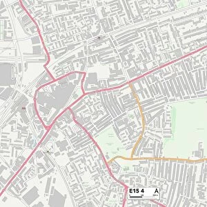
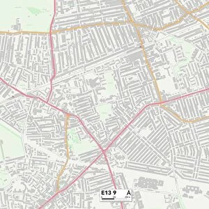
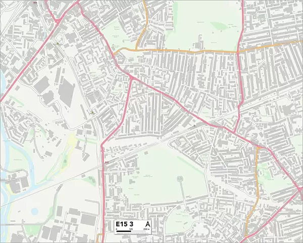
Metal Print : Newham E15 3 Map


![]()
Metal Prints from Map Marketing
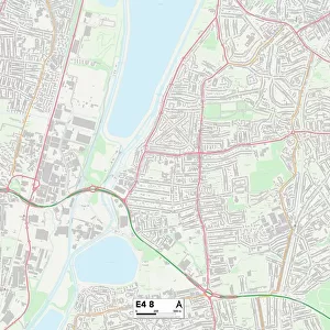
Newham E15 3 Map
Postcode Sector Map of Newham E15 3
Media ID 19969760
Abbey Road Bridge Road Canning Road Celandine Way Chaplin Road Church Street Corporation Street Dell Close Durban Road East Road Eastbourne Road Gainsborough Road Hamilton Road Harcourt Road Holbrook Road Holland Road John Street Kay Street Manor Road Marcus Street Memorial Avenue Milner Road Morley Road Napier Road Newham Park Grove Park Road Pond Road Portway Ranelagh Road Richardson Road Springfield Road Stephens Road Teasel Way West Road Willis Road West Ham
16"x20" (51x41cm) Metal Print
Made with durable metal and luxurious printing techniques, our metal photo prints go beyond traditional canvases, adding a cool, modern touch to your space. Wall mount on back. Eco-friendly 100% post-consumer recycled ChromaLuxe aluminum surface. The thickness of the print is 0.045". Featuring a Scratch-resistant surface and Rounded corners. Backing hangers are attached to the back of the print and float the print 1/2-inch off the wall when hung, the choice of hanger may vary depending on size and International orders will come with Float Mount hangers only. Finished with a brilliant white high gloss surface for unsurpassed detail and vibrance. Printed using Dye-Sublimation and for best care we recommend a non-ammonia glass cleaner, water, or isopropyl (rubbing) alcohol to prevent harming the print surface. We recommend using a clean, lint-free cloth to wipe off the print. The ultra-hard surface is scratch-resistant, waterproof and weatherproof. Avoid direct sunlight exposure.
Made with durable metal and luxurious printing techniques, metal prints bring images to life and add a modern touch to any space
Estimated Image Size (if not cropped) is 50.8cm x 40.6cm (20" x 16")
Estimated Product Size is 51.4cm x 41.2cm (20.2" x 16.2")
These are individually made so all sizes are approximate
Artwork printed orientated as per the preview above, with landscape (horizontal) orientation to match the source image.
FEATURES IN THESE COLLECTIONS
> Map Marketing
> Postcode Sector Maps
> E - London E
> Animals
> Birds
> Passerines
> Crows And Jays
> Related Images
> Arts
> Artists
> K
> John Kay
> Europe
> United Kingdom
> England
> London
> Boroughs
> Newham
> Europe
> United Kingdom
> England
> London
> Sights
> Holland Park
> Europe
> United Kingdom
> Scotland
> Strathclyde
> Hamilton
> Maps and Charts
> Related Images
> North America
> Saint Lucia
> Maps
MADE IN THE USA
Safe Shipping with 30 Day Money Back Guarantee
FREE PERSONALISATION*
We are proud to offer a range of customisation features including Personalised Captions, Color Filters and Picture Zoom Tools
SECURE PAYMENTS
We happily accept a wide range of payment options so you can pay for the things you need in the way that is most convenient for you
* Options may vary by product and licensing agreement. Zoomed Pictures can be adjusted in the Cart.