Metal Print > MapSeeker > British Town And City Plans > English & Welsh PORTFOLIO
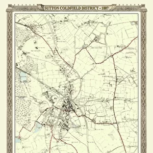
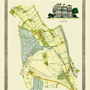
Metal Print : Old Map of the Royal Town of Sutton Coldfield 1765 by John Snape


![]()
Metal Prints from MapSeeker
Old Map of the Royal Town of Sutton Coldfield 1765 by John Snape
PL042
Welcome to the Mapseeker Image library and enter an historic gateway to one of the largest on-line collections of Historic Maps, Nostalgic Views, Vista's and Panorama's from a World gone by.
Media ID 20347319
Historic Map Old Town Plan Town Plan Sutton Coldfield
16"x24" (61x41cm) Metal Print
Step back in time with our exquisite Metal Print of an Old Map of Sutton Coldfield 1765 by John Snape from MapSeeker (PL042). This stunning piece of decor showcases intricate cartography and historical detail, transporting you back to an era of horse-drawn carriages and quaint townscapes. The vibrant colors and high-quality finish of our Metal Prints bring out the rich textures and nuances of the map, making it a captivating conversation starter in any room. Add a touch of history and sophistication to your home or office with this beautiful and unique addition to your decor collection.
Made with durable metal and luxurious printing techniques, our metal photo prints go beyond traditional canvases, adding a cool, modern touch to your space. Wall mount on back. Eco-friendly 100% post-consumer recycled ChromaLuxe aluminum surface. The thickness of the print is 0.045". Featuring a Scratch-resistant surface and Rounded corners. Backing hangers are attached to the back of the print and float the print 1/2-inch off the wall when hung, the choice of hanger may vary depending on size and International orders will come with Float Mount hangers only. Finished with a brilliant white high gloss surface for unsurpassed detail and vibrance. Printed using Dye-Sublimation and for best care we recommend a non-ammonia glass cleaner, water, or isopropyl (rubbing) alcohol to prevent harming the print surface. We recommend using a clean, lint-free cloth to wipe off the print. The ultra-hard surface is scratch-resistant, waterproof and weatherproof. Avoid direct sunlight exposure.
Made with durable metal and luxurious printing techniques, metal prints bring images to life and add a modern touch to any space
Estimated Product Size is 41.2cm x 61.5cm (16.2" x 24.2")
These are individually made so all sizes are approximate
Artwork printed orientated as per the preview above, with portrait (vertical) orientation to match the source image.
EDITORS COMMENTS
This print showcases the "Old Map of the Royal Town of Sutton Coldfield 1765" by John Snape (PL042), offering a fascinating glimpse into the rich history and heritage of this charming town. With its intricate details and exquisite craftsmanship, this old map transports us back in time to an era when Sutton Coldfield was still in its infancy. The map provides a comprehensive view of the town's layout, depicting streets, landmarks, and even individual buildings with remarkable precision. It serves as a testament to the meticulousness and dedication of cartographer John Snape, who painstakingly captured every aspect of Sutton Coldfield's urban landscape. As we explore this historic document, we can't help but marvel at how much has changed over the centuries. The bustling market square depicted on the map has transformed into a modern hub for shopping and socializing. Ancient roads have been widened or rerouted to accommodate growing traffic demands. Yet amidst all these transformations, traces of Sutton Coldfield's past still linger within its present-day fabric. This print is not just an artistic masterpiece; it also holds immense value for those interested in local history or genealogy research. Whether you're a resident seeking to connect with your town's roots or an enthusiast delving into historical cartography, this old map offers endless possibilities for exploration and discovery. Displaying this stunning piece in your home or office will undoubtedly spark conversations about Sutton Coldfield's evolution through time while honoring its enduring legacy as a royal town steeped in tradition
MADE IN THE USA
Safe Shipping with 30 Day Money Back Guarantee
FREE PERSONALISATION*
We are proud to offer a range of customisation features including Personalised Captions, Color Filters and Picture Zoom Tools
SECURE PAYMENTS
We happily accept a wide range of payment options so you can pay for the things you need in the way that is most convenient for you
* Options may vary by product and licensing agreement. Zoomed Pictures can be adjusted in the Cart.