Pillow > Maps and Charts > Related Images
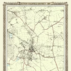
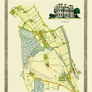
Pillow : Old Map of the Royal Town of Sutton Coldfield 1765 by John Snape


![]()
Home Decor from MapSeeker
Old Map of the Royal Town of Sutton Coldfield 1765 by John Snape
PL042
Welcome to the Mapseeker Image library and enter an historic gateway to one of the largest on-line collections of Historic Maps, Nostalgic Views, Vista's and Panorama's from a World gone by.
Media ID 20347319
Historic Map Old Town Plan Town Plan Sutton Coldfield
18"x18" (46x46cm) Pillow
18"x18" (46x46cm) Faux Suede Pillow with a plush soft feel. Your choice of image fills the front, with a stone colored faux suede back. Flat sewn concealed white zip.
Accessorise your space with decorative, soft pillows
Estimated Product Size is 45.7cm x 45.7cm (18" x 18")
These are individually made so all sizes are approximate
Artwork printed orientated as per the preview above, with landscape (horizontal) or portrait (vertical) orientation to match the source image.
FEATURES IN THESE COLLECTIONS
> MapSeeker
> British Town And City Plans
> English & Welsh PORTFOLIO
> Maps and Charts
> Related Images
EDITORS COMMENTS
This print showcases the "Old Map of the Royal Town of Sutton Coldfield 1765" by John Snape (PL042), offering a fascinating glimpse into the rich history and heritage of this charming town. With its intricate details and exquisite craftsmanship, this old map transports us back in time to an era when Sutton Coldfield was still in its infancy. The map provides a comprehensive view of the town's layout, depicting streets, landmarks, and even individual buildings with remarkable precision. It serves as a testament to the meticulousness and dedication of cartographer John Snape, who painstakingly captured every aspect of Sutton Coldfield's urban landscape. As we explore this historic document, we can't help but marvel at how much has changed over the centuries. The bustling market square depicted on the map has transformed into a modern hub for shopping and socializing. Ancient roads have been widened or rerouted to accommodate growing traffic demands. Yet amidst all these transformations, traces of Sutton Coldfield's past still linger within its present-day fabric. This print is not just an artistic masterpiece; it also holds immense value for those interested in local history or genealogy research. Whether you're a resident seeking to connect with your town's roots or an enthusiast delving into historical cartography, this old map offers endless possibilities for exploration and discovery. Displaying this stunning piece in your home or office will undoubtedly spark conversations about Sutton Coldfield's evolution through time while honoring its enduring legacy as a royal town steeped in tradition
MADE IN THE USA
Safe Shipping with 30 Day Money Back Guarantee
FREE PERSONALISATION*
We are proud to offer a range of customisation features including Personalised Captions, Color Filters and Picture Zoom Tools
SECURE PAYMENTS
We happily accept a wide range of payment options so you can pay for the things you need in the way that is most convenient for you
* Options may vary by product and licensing agreement. Zoomed Pictures can be adjusted in the Cart.