Metal Print > Arts > Artists > T > John Tallis
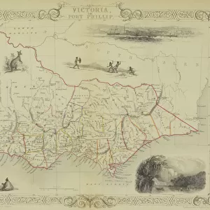
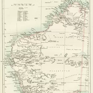
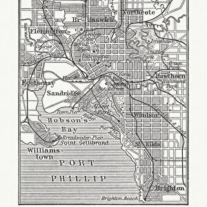
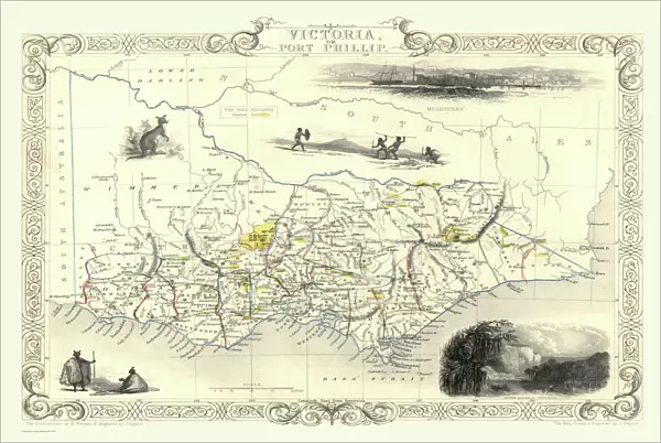
Metal Print : Victoria, or Port Phillip 1851


![]()
Metal Prints from MapSeeker
Victoria, or Port Phillip 1851
A fine facimile artworked from an antique original map of Victoria, or Port Phillip, Australia, issued as part of the 1851 edition of John Tallis and Companys " The Illustrated Atlas and Modern History of the World"
Welcome to the Mapseeker Image library and enter an historic gateway to one of the largest on-line collections of Historic Maps, Nostalgic Views, Vista's and Panorama's from a World gone by.
Media ID 20347408
© Mapseeker Publishing Ltd
John Tallis John Tallis Map Tallis Map Port Phillip
16"x24" (61x41cm) Metal Print
Step back in time with our exquisite Media Storehouse Metal Prints featuring the vintage map of Victoria, or Port Phillip, by John Tallis and John Rapkin from MapSeeker. This fine facsimile artwork is meticulously reproduced from an original antique map published in the 1851 edition of "The Illustrated Atlas." Add a touch of history and elegance to your space with this stunning, high-definition metal print. The vibrant colors and exceptional detail bring the beauty of 19th-century cartography to life, making it a unique and captivating addition to any room. Order yours today and let the rich history of Victoria, Australia, be the centerpiece of your home or office decor.
Made with durable metal and luxurious printing techniques, our metal photo prints go beyond traditional canvases, adding a cool, modern touch to your space. Wall mount on back. Eco-friendly 100% post-consumer recycled ChromaLuxe aluminum surface. The thickness of the print is 0.045". Featuring a Scratch-resistant surface and Rounded corners. Backing hangers are attached to the back of the print and float the print 1/2-inch off the wall when hung, the choice of hanger may vary depending on size and International orders will come with Float Mount hangers only. Finished with a brilliant white high gloss surface for unsurpassed detail and vibrance. Printed using Dye-Sublimation and for best care we recommend a non-ammonia glass cleaner, water, or isopropyl (rubbing) alcohol to prevent harming the print surface. We recommend using a clean, lint-free cloth to wipe off the print. The ultra-hard surface is scratch-resistant, waterproof and weatherproof. Avoid direct sunlight exposure.
Made with durable metal and luxurious printing techniques, metal prints bring images to life and add a modern touch to any space
Estimated Product Size is 61.5cm x 41.2cm (24.2" x 16.2")
These are individually made so all sizes are approximate
Artwork printed orientated as per the preview above, with landscape (horizontal) orientation to match the source image.
FEATURES IN THESE COLLECTIONS
> MapSeeker
> Maps of Africa and Oceana
> Old Maps of Australia PORTFOLIO
> Arts
> Artists
> P
> John Phillip
> Arts
> Artists
> T
> John Tallis
> Maps and Charts
> Related Images
> Maps and Charts
> World
> Oceania
> Australia
> Related Images
EDITORS COMMENTS
This print showcases a remarkable piece of history - a fine facsimile artworked from an antique original map of Victoria, or Port Phillip, Australia. This extraordinary map was originally issued as part of the 1851 edition of John Tallis and Company's "The Illustrated Atlas and Modern History of the World". Transporting us back to the mid-19th century, this old map offers a glimpse into Australia's past with intricate details that highlight its rich heritage. The carefully crafted lines and delicate shading bring to life the vast expanse of Victoria, revealing its diverse landscapes and geographical features. John Tallis, renowned for his cartographic expertise, collaborated with talented artist John Rapkin to create this masterpiece. Their combined efforts resulted in a visually stunning representation that captures the essence of Victoria during this significant era. As we explore this vintage treasure, it becomes evident why maps hold such fascination for historians and enthusiasts alike. They serve as windows into bygone times, allowing us to trace the footsteps of those who came before us. Whether you are an avid collector or simply appreciate historical artifacts, this print is sure to captivate your imagination. Display it proudly on your wall as a testament to both Victorian history and the artistry involved in creating such magnificent cartographic works.
MADE IN THE USA
Safe Shipping with 30 Day Money Back Guarantee
FREE PERSONALISATION*
We are proud to offer a range of customisation features including Personalised Captions, Color Filters and Picture Zoom Tools
SECURE PAYMENTS
We happily accept a wide range of payment options so you can pay for the things you need in the way that is most convenient for you
* Options may vary by product and licensing agreement. Zoomed Pictures can be adjusted in the Cart.