Photographic Print > Arts > Artists > T > John Tallis
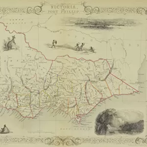
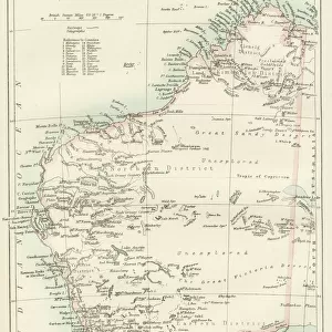
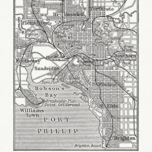
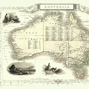
Photographic Print : Victoria, or Port Phillip 1851


![]()
Photo Prints from MapSeeker
Victoria, or Port Phillip 1851
A fine facimile artworked from an antique original map of Victoria, or Port Phillip, Australia, issued as part of the 1851 edition of John Tallis and Companys " The Illustrated Atlas and Modern History of the World"
Welcome to the Mapseeker Image library and enter an historic gateway to one of the largest on-line collections of Historic Maps, Nostalgic Views, Vista's and Panorama's from a World gone by.
Media ID 20347408
© Mapseeker Publishing Ltd
John Tallis John Tallis Map Tallis Map Port Phillip
11"x8.5" Photo Print
Introducing the Media Storehouse range of Photographic Prints featuring the captivating artwork "Victoria, or Port Phillip 1851" by John Tallis and John Rapkin from MapSeeker. This exquisite facsimile is taken from an original antique map published in the 1851 edition of John Tallis and Company's "The Illustrated Atlas." Transport yourself back in time with this intricately detailed representation of Victoria, Australia, as it appeared over 170 years ago. Each print is meticulously reproduced to preserve the authenticity and character of the original, making it a stunning addition to any home or office decor. Order yours today and bring a piece of history into your space.
Photo prints are produced on Kodak professional photo paper resulting in timeless and breath-taking prints which are also ideal for framing. The colors produced are rich and vivid, with accurate blacks and pristine whites, resulting in prints that are truly timeless and magnificent. Whether you're looking to display your prints in your home, office, or gallery, our range of photographic prints are sure to impress. Dimensions refers to the size of the paper in inches.
Our Photo Prints are in a large range of sizes and are printed on Archival Quality Paper for excellent colour reproduction and longevity. They are ideal for framing (our Framed Prints use these) at a reasonable cost. Alternatives include cheaper Poster Prints and higher quality Fine Art Paper, the choice of which is largely dependant on your budget.
Estimated Image Size (if not cropped) is 27.9cm x 18.6cm (11" x 7.3")
Estimated Product Size is 27.9cm x 21.6cm (11" x 8.5")
These are individually made so all sizes are approximate
Artwork printed orientated as per the preview above, with landscape (horizontal) orientation to match the source image.
FEATURES IN THESE COLLECTIONS
> MapSeeker
> Maps of Africa and Oceana
> Old Maps of Australia PORTFOLIO
> Arts
> Artists
> P
> John Phillip
> Arts
> Artists
> T
> John Tallis
> Maps and Charts
> Related Images
> Maps and Charts
> World
> Oceania
> Australia
> Related Images
EDITORS COMMENTS
This print showcases a remarkable piece of history - a fine facsimile artworked from an antique original map of Victoria, or Port Phillip, Australia. This extraordinary map was originally issued as part of the 1851 edition of John Tallis and Company's "The Illustrated Atlas and Modern History of the World". Transporting us back to the mid-19th century, this old map offers a glimpse into Australia's past with intricate details that highlight its rich heritage. The carefully crafted lines and delicate shading bring to life the vast expanse of Victoria, revealing its diverse landscapes and geographical features. John Tallis, renowned for his cartographic expertise, collaborated with talented artist John Rapkin to create this masterpiece. Their combined efforts resulted in a visually stunning representation that captures the essence of Victoria during this significant era. As we explore this vintage treasure, it becomes evident why maps hold such fascination for historians and enthusiasts alike. They serve as windows into bygone times, allowing us to trace the footsteps of those who came before us. Whether you are an avid collector or simply appreciate historical artifacts, this print is sure to captivate your imagination. Display it proudly on your wall as a testament to both Victorian history and the artistry involved in creating such magnificent cartographic works.
MADE IN THE USA
Safe Shipping with 30 Day Money Back Guarantee
FREE PERSONALISATION*
We are proud to offer a range of customisation features including Personalised Captions, Color Filters and Picture Zoom Tools
SECURE PAYMENTS
We happily accept a wide range of payment options so you can pay for the things you need in the way that is most convenient for you
* Options may vary by product and licensing agreement. Zoomed Pictures can be adjusted in the Cart.