Metal Print > Arts > Photorealistic artworks > Detailed art pieces > Masterful detailing in art
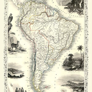
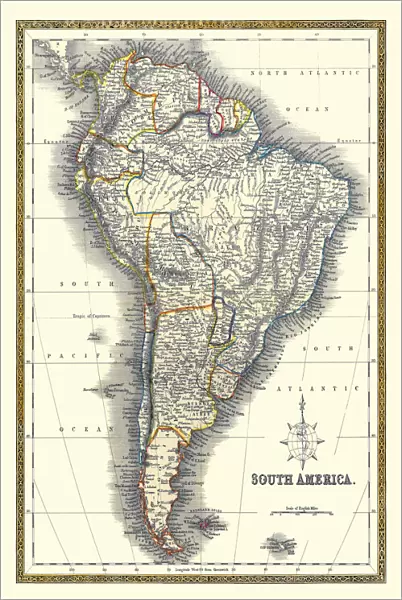
Metal Print : Old Map of South America 1852 by Henry George Collins

![]()
Metal Prints from MapSeeker
Old Map of South America 1852 by Henry George Collins
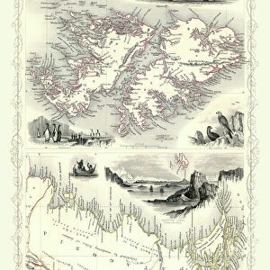
This is a finely detailed map of South America remastered from a rare Atlas of the World published in 1852 by Henry George Collins. Although these Henry Collins produced maps of the highest quality in his time unfortunately not the same could be said in terms of his business success. His maps were later obtained by the famous Stanford Map Company and used in their publications
Welcome to the Mapseeker Image library and enter an historic gateway to one of the largest on-line collections of Historic Maps, Nostalgic Views, Vista's and Panorama's from a World gone by.
Media ID 20347424
© Mapseeker Publishing Ltd
Collins Collins Atlas Collins Atlas Map Collins Map Continental Map Old Continental Map
16"x24" (61x41cm) Metal Print
Discover history with our exquisite Metal Prints featuring the Old Map of South America by Henry George Collins from MapSeeker. This finely detailed map, published in an 1852 Atlas, showcases the intricate cartography of South America during a pivotal period in its history. Each Metal Print is meticulously remastered from the original map, ensuring the highest quality and authenticity. Bring a piece of historical cartography into your home or office and add an element of sophistication and intrigue. Order now and relive the past with our stunning Metal Prints.
Made with durable metal and luxurious printing techniques, our metal photo prints go beyond traditional canvases, adding a cool, modern touch to your space. Wall mount on back. Eco-friendly 100% post-consumer recycled ChromaLuxe aluminum surface. The thickness of the print is 0.045". Featuring a Scratch-resistant surface and Rounded corners. Backing hangers are attached to the back of the print and float the print 1/2-inch off the wall when hung, the choice of hanger may vary depending on size and International orders will come with Float Mount hangers only. Finished with a brilliant white high gloss surface for unsurpassed detail and vibrance. Printed using Dye-Sublimation and for best care we recommend a non-ammonia glass cleaner, water, or isopropyl (rubbing) alcohol to prevent harming the print surface. We recommend using a clean, lint-free cloth to wipe off the print. The ultra-hard surface is scratch-resistant, waterproof and weatherproof. Avoid direct sunlight exposure.
Made with durable metal and luxurious printing techniques, metal prints bring images to life and add a modern touch to any space
Estimated Product Size is 41.2cm x 61.5cm (16.2" x 24.2")
These are individually made so all sizes are approximate
Artwork printed orientated as per the preview above, with portrait (vertical) orientation to match the source image.
FEATURES IN THESE COLLECTIONS
> MapSeeker
> Maps of the Americas
> Maps of Central and South America
> Arts
> Photorealistic artworks
> Detailed art pieces
> Masterful detailing in art
> Maps and Charts
> Related Images
> Maps and Charts
> World
> South America
> Related Images
EDITORS COMMENTS
This beautifully preserved print showcases an exquisite "Old Map of South America 1852" by the talented cartographer Henry George Collins. Remastered from a rare Atlas of the World published in 1852, this map offers a fascinating glimpse into the geographical knowledge and artistic prowess of that era. Henry Collins was renowned for his exceptional craftsmanship, evident in the intricate details and accuracy portrayed on this map. However, despite his remarkable talent, he faced challenges in achieving commercial success. Fortunately, these extraordinary maps found their way into the hands of the esteemed Stanford Map Company, who recognized their value and incorporated them into their own publications. As we explore this vintage depiction of South America, we are transported back to a time when exploration and discovery were at their peak. Every contour line and coastline is meticulously delineated with precision and care. The names of cities, rivers, mountains, and countries evoke a sense of history unfolding before our eyes. This old continental map serves as both an educational tool for geography enthusiasts and a captivating piece of art for collectors. It reminds us not only of Henry George Collins' immense talent but also highlights how historical artifacts can transcend time to captivate modern audiences. Whether you are fascinated by cartography or simply appreciate the beauty inherent in antique prints like this one, "Old Map of South America 1852" will undoubtedly enrich your understanding while adding a touch of elegance to any space it graces.
MADE IN THE USA
Safe Shipping with 30 Day Money Back Guarantee
FREE PERSONALISATION*
We are proud to offer a range of customisation features including Personalised Captions, Color Filters and Picture Zoom Tools
SECURE PAYMENTS
We happily accept a wide range of payment options so you can pay for the things you need in the way that is most convenient for you
* Options may vary by product and licensing agreement. Zoomed Pictures can be adjusted in the Cart.