Metal Print > Arts > Photorealistic artworks > Detailed art pieces > Masterful detailing in art
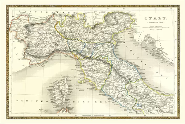
Metal Print : Old Map of Northern Italy 1852 by Henry George Collins


![]()
Metal Prints from MapSeeker
Old Map of Northern Italy 1852 by Henry George Collins
This is a finely detailed map of Northern Italy remastered from a rare Atlas of the World published in 1852 by Henry George Collins. Although these Henry Collins produced maps of the highest quality in his time unfortunately not the same could be said in terms of his business success. His maps were later obtained by the famous Stanford Map Company and used in their publications
Welcome to the Mapseeker Image library and enter an historic gateway to one of the largest on-line collections of Historic Maps, Nostalgic Views, Vista's and Panorama's from a World gone by.
Media ID 20347434
© Mapseeker Publishing Ltd
Collins Collins Atlas Collins Atlas Map Collins Map North Italy Northern Italy
16"x24" (61x41cm) Metal Print
Discover the rich history of Northern Italy with our stunning Metal Print of the Old Map of Northern Italy 1852 by Henry George Collins. Meticulously remastered from the rare Atlas of the World published by Henry George Collins, this finely detailed map transports you back in time. The vintage cartography and intricate borders are brought to life with our high-quality metal print process, creating a unique and captivating piece of art for your home or office. Add a touch of history and sophistication to your space with this beautiful and intriguing representation of Northern Italy in a bygone era.
Made with durable metal and luxurious printing techniques, our metal photo prints go beyond traditional canvases, adding a cool, modern touch to your space. Wall mount on back. Eco-friendly 100% post-consumer recycled ChromaLuxe aluminum surface. The thickness of the print is 0.045". Featuring a Scratch-resistant surface and Rounded corners. Backing hangers are attached to the back of the print and float the print 1/2-inch off the wall when hung, the choice of hanger may vary depending on size and International orders will come with Float Mount hangers only. Finished with a brilliant white high gloss surface for unsurpassed detail and vibrance. Printed using Dye-Sublimation and for best care we recommend a non-ammonia glass cleaner, water, or isopropyl (rubbing) alcohol to prevent harming the print surface. We recommend using a clean, lint-free cloth to wipe off the print. The ultra-hard surface is scratch-resistant, waterproof and weatherproof. Avoid direct sunlight exposure.
Made with durable metal and luxurious printing techniques, metal prints bring images to life and add a modern touch to any space
Estimated Product Size is 61.5cm x 41.2cm (24.2" x 16.2")
These are individually made so all sizes are approximate
Artwork printed orientated as per the preview above, with landscape (horizontal) orientation to match the source image.
FEATURES IN THESE COLLECTIONS
> MapSeeker
> Maps of Europe
> Maps of Italy PORTFOLIO
> Arts
> Photorealistic artworks
> Detailed art pieces
> Masterful detailing in art
> Maps and Charts
> Italy
> Maps and Charts
> Related Images
> Maps and Charts
> World
EDITORS COMMENTS
This beautifully preserved print showcases an exquisite piece of cartographic history - the "Old Map of Northern Italy 1852" by Henry George Collins. Remastered from a rare Atlas of the World published in 1852, this map offers a finely detailed depiction of Northern Italy during that era. Henry George Collins was renowned for producing maps of unparalleled quality in his time, and this masterpiece is no exception. However, despite his exceptional craftsmanship, Collins did not achieve significant business success. Fortunately, his remarkable maps found their way into the hands of the prestigious Stanford Map Company, who recognized their value and incorporated them into their own publications. The intricate details on this old Italian map provide a captivating glimpse into the past. From the majestic Alps to the picturesque lakes and charming towns scattered across its surface, every corner of Northern Italy is meticulously represented. This historic document serves as a testament to both Collins' skill as a cartographer and to the rich cultural heritage embedded within these lands. Whether you are an avid collector or simply fascinated by historical artifacts, this print invites you to explore Northern Italy's enchanting landscapes through a lens frozen in time. It captures not only geographical boundaries but also whispers stories from generations long gone – tales waiting to be discovered by those who appreciate both artistry and history intertwined within one extraordinary creation.
MADE IN THE USA
Safe Shipping with 30 Day Money Back Guarantee
FREE PERSONALISATION*
We are proud to offer a range of customisation features including Personalised Captions, Color Filters and Picture Zoom Tools
SECURE PAYMENTS
We happily accept a wide range of payment options so you can pay for the things you need in the way that is most convenient for you
* Options may vary by product and licensing agreement. Zoomed Pictures can be adjusted in the Cart.