Metal Print > Africa > Related Images
Metal Print : Map of British Empire showing international cable


![]()
Metal Prints from Mary Evans Picture Library
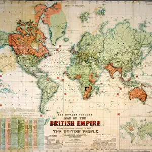
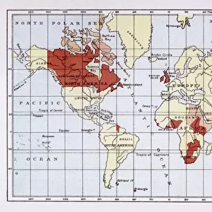
Map of British Empire showing international cable
Map of the British Empire (coloured red), showing the All-British international cable going round the world, enabling telegraphic communication. Date: circa 1902
Mary Evans Picture Library makes available wonderful images created for people to enjoy over the centuries
Media ID 14164147
© Mary Evans / Pharcide
Cable Commonwealth Communication Guiana Honduras Jack Patriotic Patriotism Technology Telegraph Telegraphic Zealand 1902
16"x24" (61x41cm) Metal Print
Discover the rich history of global communication with our stunning Metal Prints from Media Storehouse. Featuring an iconic Map of the British Empire from Mary Evans Prints Online (circa 1902), this captivating design showcases the extensive reach of the All-British international cable system in vibrant red tones. Each Metal Print is meticulously crafted with a durable, high-gloss finish that brings out the intricate details of the map and adds a contemporary twist to your decor. Transport yourself back in time and celebrate the milestone achievements in telegraphic communication with this unique and eye-catching piece.
Made with durable metal and luxurious printing techniques, our metal photo prints go beyond traditional canvases, adding a cool, modern touch to your space. Wall mount on back. Eco-friendly 100% post-consumer recycled ChromaLuxe aluminum surface. The thickness of the print is 0.045". Featuring a Scratch-resistant surface and Rounded corners. Backing hangers are attached to the back of the print and float the print 1/2-inch off the wall when hung, the choice of hanger may vary depending on size and International orders will come with Float Mount hangers only. Finished with a brilliant white high gloss surface for unsurpassed detail and vibrance. Printed using Dye-Sublimation and for best care we recommend a non-ammonia glass cleaner, water, or isopropyl (rubbing) alcohol to prevent harming the print surface. We recommend using a clean, lint-free cloth to wipe off the print. The ultra-hard surface is scratch-resistant, waterproof and weatherproof. Avoid direct sunlight exposure.
Made with durable metal and luxurious printing techniques, metal prints bring images to life and add a modern touch to any space
Estimated Product Size is 61.5cm x 41.2cm (24.2" x 16.2")
These are individually made so all sizes are approximate
Artwork printed orientated as per the preview above, with landscape (horizontal) orientation to match the source image.
FEATURES IN THESE COLLECTIONS
> Africa
> Related Images
> Asia
> India
> Related Images
> Europe
> United Kingdom
> Maps
> Maps and Charts
> British Empire Maps
> Maps and Charts
> Early Maps
> Maps and Charts
> India
> Maps and Charts
> Related Images
EDITORS COMMENTS
This map print, dated circa 1902, presents a vivid representation of the British Empire at the height of its global influence. The map is adorned with the red hue, symbolizing the territorial reach of the British monarchy, which extended across every corner of the world. At the heart of this imperial tapestry lies an intricate network of international telegraph cables, depicted in thick, unbroken lines. These cables, a marvel of late-Victorian technology, encircled the globe, connecting the far-flung corners of the Empire and enabling instantaneous telegraphic communication. The map's title, "Map of the British Empire," is accompanied by the image of the Union Jack flag, a potent symbol of British patriotism and unity. The flags of various dominions, including Canada, Australia, India, New Zealand, and even Guiana and Honduras, are also displayed, reflecting the diverse and expansive nature of the Empire. This map serves as a testament to the remarkable achievements of the British Empire during this period, as well as the transformative impact of telegraphic communication technology on global connections. The ability to send messages across vast distances in a matter of minutes revolutionized the way information was shared, facilitated diplomacy, and fostered a sense of unity among the disparate parts of the Empire. As you gaze upon this evocative map, one cannot help but be struck by the sense of awe and wonder that must have accompanied the realization of such a vast and interconnected world. This historical artifact is a poignant reminder of the past, offering valuable insights into the rich tapestry of British history and the enduring legacy of the Empire.
MADE IN THE USA
Safe Shipping with 30 Day Money Back Guarantee
FREE PERSONALISATION*
We are proud to offer a range of customisation features including Personalised Captions, Color Filters and Picture Zoom Tools
SECURE PAYMENTS
We happily accept a wide range of payment options so you can pay for the things you need in the way that is most convenient for you
* Options may vary by product and licensing agreement. Zoomed Pictures can be adjusted in the Cart.