Photographic Print > Africa > Related Images
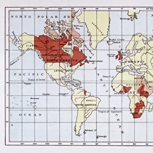
Photographic Print : Map of British Empire showing international cable


![]()
Photo Prints from Mary Evans Picture Library
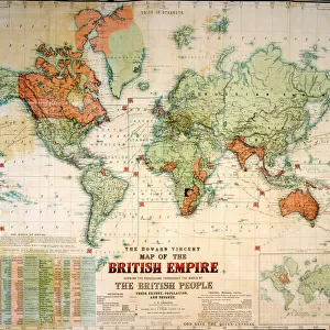
Map of British Empire showing international cable
Map of the British Empire (coloured red), showing the All-British international cable going round the world, enabling telegraphic communication. Date: circa 1902
Mary Evans Picture Library makes available wonderful images created for people to enjoy over the centuries
Media ID 14164147
© Mary Evans / Pharcide
Cable Commonwealth Communication Guiana Honduras Jack Patriotic Patriotism Technology Telegraph Telegraphic Zealand 1902
11"x8.5" Photo Print
Introducing the captivating "Map of British Empire showing international cable" print from the Media Storehouse collection, exclusively sourced from Mary Evans Prints Online. This evocative image transports us back in time to the early 20th century, showcasing the vast expanse of the British Empire in red hues. The map's most intriguing feature is the all-British international cable encircling the globe, symbolizing the groundbreaking advancements in telegraphic communication. Add this historical masterpiece to your decor and ignite conversations about the fascinating history of global connectivity.
Photo prints are produced on Kodak professional photo paper resulting in timeless and breath-taking prints which are also ideal for framing. The colors produced are rich and vivid, with accurate blacks and pristine whites, resulting in prints that are truly timeless and magnificent. Whether you're looking to display your prints in your home, office, or gallery, our range of photographic prints are sure to impress. Dimensions refers to the size of the paper in inches.
Our Photo Prints are in a large range of sizes and are printed on Archival Quality Paper for excellent colour reproduction and longevity. They are ideal for framing (our Framed Prints use these) at a reasonable cost. Alternatives include cheaper Poster Prints and higher quality Fine Art Paper, the choice of which is largely dependant on your budget.
Estimated Image Size (if not cropped) is 27.9cm x 17.6cm (11" x 6.9")
Estimated Product Size is 27.9cm x 21.6cm (11" x 8.5")
These are individually made so all sizes are approximate
Artwork printed orientated as per the preview above, with landscape (horizontal) orientation to match the source image.
FEATURES IN THESE COLLECTIONS
> Africa
> Related Images
> Asia
> India
> Related Images
> Europe
> United Kingdom
> Maps
> Maps and Charts
> British Empire Maps
> Maps and Charts
> Early Maps
> Maps and Charts
> India
> Maps and Charts
> Related Images
EDITORS COMMENTS
This map print, dated circa 1902, presents a vivid representation of the British Empire at the height of its global influence. The map is adorned with the red hue, symbolizing the territorial reach of the British monarchy, which extended across every corner of the world. At the heart of this imperial tapestry lies an intricate network of international telegraph cables, depicted in thick, unbroken lines. These cables, a marvel of late-Victorian technology, encircled the globe, connecting the far-flung corners of the Empire and enabling instantaneous telegraphic communication. The map's title, "Map of the British Empire," is accompanied by the image of the Union Jack flag, a potent symbol of British patriotism and unity. The flags of various dominions, including Canada, Australia, India, New Zealand, and even Guiana and Honduras, are also displayed, reflecting the diverse and expansive nature of the Empire. This map serves as a testament to the remarkable achievements of the British Empire during this period, as well as the transformative impact of telegraphic communication technology on global connections. The ability to send messages across vast distances in a matter of minutes revolutionized the way information was shared, facilitated diplomacy, and fostered a sense of unity among the disparate parts of the Empire. As you gaze upon this evocative map, one cannot help but be struck by the sense of awe and wonder that must have accompanied the realization of such a vast and interconnected world. This historical artifact is a poignant reminder of the past, offering valuable insights into the rich tapestry of British history and the enduring legacy of the Empire.
MADE IN THE USA
Safe Shipping with 30 Day Money Back Guarantee
FREE PERSONALISATION*
We are proud to offer a range of customisation features including Personalised Captions, Color Filters and Picture Zoom Tools
SECURE PAYMENTS
We happily accept a wide range of payment options so you can pay for the things you need in the way that is most convenient for you
* Options may vary by product and licensing agreement. Zoomed Pictures can be adjusted in the Cart.