Metal Print > Maps and Charts > Turkey
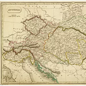
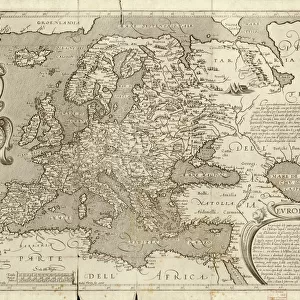
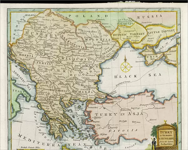
Metal Print : Map / Europe / Balkans 1792


![]()
Metal Prints from Mary Evans Picture Library
Map / Europe / Balkans 1792
A map showing Turkey in Europe and its neighbouring European states of the Balkans
Mary Evans Picture Library makes available wonderful images created for people to enjoy over the centuries
Media ID 620825
© Mary Evans Picture Library 2015 - https://copyrighthub.org/s0/hub1/creation/maryevans/MaryEvansPictureID/10074527
1792 Balkans Maps Neighbouring
16"x20" (51x41cm) Metal Print
Discover history through the captivating beauty of our Media Storehouse Metal Prints. Feast your eyes on this intriguing map from Mary Evans Prints Online, depicting Europe and the Balkans in 1792. Witness the unique allure of Turkey's European territories and its neighboring states, brought to life through the rich, vibrant colors and textures of our premium metal print finish. Perfectly preserving every detail, this stunning piece is not just a map, but a window into the past. Elevate your home or office decor with this timeless and thought-provoking addition.
Made with durable metal and luxurious printing techniques, our metal photo prints go beyond traditional canvases, adding a cool, modern touch to your space. Wall mount on back. Eco-friendly 100% post-consumer recycled ChromaLuxe aluminum surface. The thickness of the print is 0.045". Featuring a Scratch-resistant surface and Rounded corners. Backing hangers are attached to the back of the print and float the print 1/2-inch off the wall when hung, the choice of hanger may vary depending on size and International orders will come with Float Mount hangers only. Finished with a brilliant white high gloss surface for unsurpassed detail and vibrance. Printed using Dye-Sublimation and for best care we recommend a non-ammonia glass cleaner, water, or isopropyl (rubbing) alcohol to prevent harming the print surface. We recommend using a clean, lint-free cloth to wipe off the print. The ultra-hard surface is scratch-resistant, waterproof and weatherproof. Avoid direct sunlight exposure.
Made with durable metal and luxurious printing techniques, metal prints bring images to life and add a modern touch to any space
Estimated Image Size (if not cropped) is 50.8cm x 40.6cm (20" x 16")
Estimated Product Size is 51.4cm x 41.2cm (20.2" x 16.2")
These are individually made so all sizes are approximate
Artwork printed orientated as per the preview above, with landscape (horizontal) orientation to match the source image.
FEATURES IN THESE COLLECTIONS
> Asia
> Turkey
> Related Images
> Europe
> Related Images
> Maps and Charts
> Early Maps
> Maps and Charts
> Related Images
EDITORS COMMENTS
This historical map print from 1792 showcases the intricate borders and political landscape of Europe, specifically focusing on the Balkans region and Turkey in Europe. The detailed cartography highlights the neighboring European states surrounding Turkey, providing a glimpse into the complex history and territorial divisions of the time.
The map offers a fascinating insight into the geopolitical dynamics of Europe during this period, with each country clearly delineated and labeled for easy reference. From Hungary to Greece, Serbia to Bulgaria, every nation is represented on this meticulously crafted piece of historical artwork.
As we study this map, we are transported back in time to an era when empires clashed and alliances shifted constantly. The intricate details and fine craftsmanship of the map serve as a testament to the skill and dedication of cartographers from centuries past.
Whether you are a history buff or simply appreciate fine artistry, this vintage map print is sure to captivate your imagination and spark curiosity about the rich tapestry of European history. Display it proudly in your home or office as a conversation piece that will inspire discussion about our shared past and how it has shaped our present-day world.
MADE IN THE USA
Safe Shipping with 30 Day Money Back Guarantee
FREE PERSONALISATION*
We are proud to offer a range of customisation features including Personalised Captions, Color Filters and Picture Zoom Tools
SECURE PAYMENTS
We happily accept a wide range of payment options so you can pay for the things you need in the way that is most convenient for you
* Options may vary by product and licensing agreement. Zoomed Pictures can be adjusted in the Cart.