Metal Print > North America > United States of America > New York > New York > Maps
Metal Print : Map of Moscow (1836). Original drawing by W. B
. Original drawing by W. B")

![]()
Metal Prints from Mary Evans Picture Library
Map of Moscow (1836). Original drawing by W. B
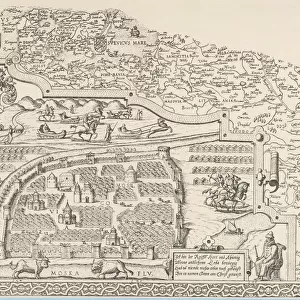
" Map of Moscow (1836). Original drawing by W.B. Clarke and engraving by B. Davies, originally published under supervision of the Society for the Diffusion of Useful Knowledge. From the work " De comparative urban design", by Melville C. Branch (New York, 1978). Engraving. SPAIN. Barcelona. Biblioteca de Catalunya (National Library of Catalonia)."
Mary Evans Picture Library makes available wonderful images created for people to enjoy over the centuries
Media ID 8277671
© Mary Evans Picture Library 2015 - https://copyrighthub.org/s0/hub1/creation/maryevans/MaryEvansPictureID/10684015
Clarke Comparative Davies Diffusion Knowledge Melville Moscow Originally Supervision
20"x24" (61x51cm) Metal Print
Discover the rich history of Moscow with our stunning Metal Print of the 1836 Map. This exquisite piece, originally drawn by W.B. Clarke and engraved by B. Davies, showcases intricate details of the city as it was over 180 years ago. Part of the Media Storehouse's exclusive collection from Mary Evans Prints Online, this Rights Managed image is beautifully brought to life on a high-quality metal print, creating a unique and captivating piece for your home or office. Relive the past and add a touch of history to your space with this impressive Moscow Map Metal Print.
Made with durable metal and luxurious printing techniques, our metal photo prints go beyond traditional canvases, adding a cool, modern touch to your space. Wall mount on back. Eco-friendly 100% post-consumer recycled ChromaLuxe aluminum surface. The thickness of the print is 0.045". Featuring a Scratch-resistant surface and Rounded corners. Backing hangers are attached to the back of the print and float the print 1/2-inch off the wall when hung, the choice of hanger may vary depending on size and International orders will come with Float Mount hangers only. Finished with a brilliant white high gloss surface for unsurpassed detail and vibrance. Printed using Dye-Sublimation and for best care we recommend a non-ammonia glass cleaner, water, or isopropyl (rubbing) alcohol to prevent harming the print surface. We recommend using a clean, lint-free cloth to wipe off the print. The ultra-hard surface is scratch-resistant, waterproof and weatherproof. Avoid direct sunlight exposure.
Made with durable metal and luxurious printing techniques, metal prints bring images to life and add a modern touch to any space
Estimated Image Size (if not cropped) is 60.9cm x 50.8cm (24" x 20")
Estimated Product Size is 61.5cm x 51.4cm (24.2" x 20.2")
These are individually made so all sizes are approximate
Artwork printed orientated as per the preview above, with landscape (horizontal) orientation to match the source image.
FEATURES IN THESE COLLECTIONS
> Europe
> Spain
> Related Images
> Maps and Charts
> Related Images
> Maps and Charts
> Spain
> North America
> United States of America
> New York
> New York
> Maps
> North America
> United States of America
> New York
> Related Images
EDITORS COMMENTS
This print showcases an original drawing of Moscow, created by W.B. Clarke in 1836 and beautifully engraved by B. Davies under the supervision of the Society for the Diffusion of Useful Knowledge. The map, published in Melville C. Branch's work "De comparative urban design," offers a fascinating glimpse into the urban layout of Moscow during that era. The intricate details of the map reveal the city's complex network of streets, canals, and landmarks. The Kremlin, Moscow's historic fortress and the official residence of the Russian president, stands proudly at the heart of the city. The Moskva River, a significant waterway that runs through Moscow, is also clearly depicted. The Society for the Diffusion of Useful Knowledge was a British organization dedicated to the dissemination of knowledge through various means, including the publication of educational materials. This map is a testament to their commitment to making geographical and urban knowledge accessible to a wider audience. The print is now part of the impressive collection at the Biblioteca de Catalunya (National Library of Catalonia) in Barcelona, Spain. Its preservation ensures that this valuable piece of historical cartography continues to inspire curiosity and fascination among scholars, urban planners, and history enthusiasts alike.
MADE IN THE USA
Safe Shipping with 30 Day Money Back Guarantee
FREE PERSONALISATION*
We are proud to offer a range of customisation features including Personalised Captions, Color Filters and Picture Zoom Tools
SECURE PAYMENTS
We happily accept a wide range of payment options so you can pay for the things you need in the way that is most convenient for you
* Options may vary by product and licensing agreement. Zoomed Pictures can be adjusted in the Cart.