Photographic Print > North America > United States of America > New York > New York > Maps
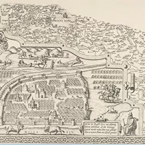
Photographic Print : Map of Moscow (1836). Original drawing by W. B
. Original drawing by W. B")

![]()
Photo Prints from Mary Evans Picture Library
Map of Moscow (1836). Original drawing by W. B
" Map of Moscow (1836). Original drawing by W.B. Clarke and engraving by B. Davies, originally published under supervision of the Society for the Diffusion of Useful Knowledge. From the work " De comparative urban design", by Melville C. Branch (New York, 1978). Engraving. SPAIN. Barcelona. Biblioteca de Catalunya (National Library of Catalonia)."
Mary Evans Picture Library makes available wonderful images created for people to enjoy over the centuries
Media ID 8277671
© Mary Evans Picture Library 2015 - https://copyrighthub.org/s0/hub1/creation/maryevans/MaryEvansPictureID/10684015
Clarke Comparative Davies Diffusion Knowledge Melville Moscow Originally Supervision
10"x10" Photo Print
Discover the rich history of Moscow with our stunning, high-quality photographic print of "Map of Moscow (1836)" from the Media Storehouse collection. Originally drawn by W.B. Clarke and meticulously engraved by B. Davies, this captivating antique map was published under the supervision of the Society for the Diffusion of Useful Knowledge. Bring the historical charm of 19th century cartography into your home or office, and add an elegant touch to your decor. Our photographic prints are available for rights-managed use only, ensuring the authenticity and exclusivity of your purchase. Transport yourself back in time and explore the intricate details of this exquisite piece of cartographic history.
Photo prints are produced on Kodak professional photo paper resulting in timeless and breath-taking prints which are also ideal for framing. The colors produced are rich and vivid, with accurate blacks and pristine whites, resulting in prints that are truly timeless and magnificent. Whether you're looking to display your prints in your home, office, or gallery, our range of photographic prints are sure to impress. Dimensions refers to the size of the paper in inches.
Our Photo Prints are in a large range of sizes and are printed on Archival Quality Paper for excellent colour reproduction and longevity. They are ideal for framing (our Framed Prints use these) at a reasonable cost. Alternatives include cheaper Poster Prints and higher quality Fine Art Paper, the choice of which is largely dependant on your budget.
Estimated Image Size (if not cropped) is 25.4cm x 23.1cm (10" x 9.1")
Estimated Product Size is 25.4cm x 25.4cm (10" x 10")
These are individually made so all sizes are approximate
Artwork printed orientated as per the preview above, with landscape (horizontal) orientation to match the source image.
FEATURES IN THESE COLLECTIONS
> Europe
> Spain
> Related Images
> Maps and Charts
> Related Images
> Maps and Charts
> Spain
> North America
> United States of America
> New York
> New York
> Maps
> North America
> United States of America
> New York
> Related Images
EDITORS COMMENTS
This print showcases an original drawing of Moscow, created by W.B. Clarke in 1836 and beautifully engraved by B. Davies under the supervision of the Society for the Diffusion of Useful Knowledge. The map, published in Melville C. Branch's work "De comparative urban design," offers a fascinating glimpse into the urban layout of Moscow during that era. The intricate details of the map reveal the city's complex network of streets, canals, and landmarks. The Kremlin, Moscow's historic fortress and the official residence of the Russian president, stands proudly at the heart of the city. The Moskva River, a significant waterway that runs through Moscow, is also clearly depicted. The Society for the Diffusion of Useful Knowledge was a British organization dedicated to the dissemination of knowledge through various means, including the publication of educational materials. This map is a testament to their commitment to making geographical and urban knowledge accessible to a wider audience. The print is now part of the impressive collection at the Biblioteca de Catalunya (National Library of Catalonia) in Barcelona, Spain. Its preservation ensures that this valuable piece of historical cartography continues to inspire curiosity and fascination among scholars, urban planners, and history enthusiasts alike.
MADE IN THE USA
Safe Shipping with 30 Day Money Back Guarantee
FREE PERSONALISATION*
We are proud to offer a range of customisation features including Personalised Captions, Color Filters and Picture Zoom Tools
SECURE PAYMENTS
We happily accept a wide range of payment options so you can pay for the things you need in the way that is most convenient for you
* Options may vary by product and licensing agreement. Zoomed Pictures can be adjusted in the Cart.