Metal Print > Europe > France > Canton > Landes
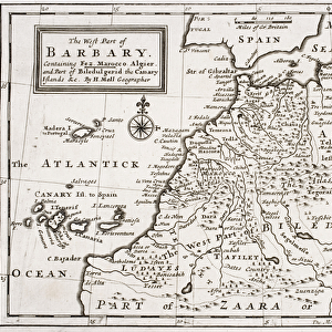
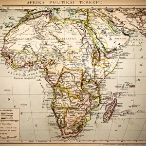
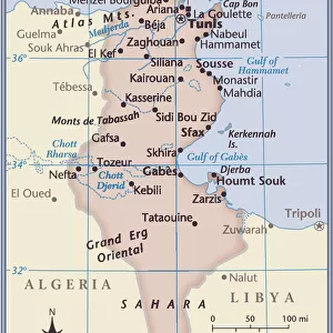
Metal Print : Map / Nw Africa 1719


![]()
Metal Prints from Mary Evans Picture Library
Map / Nw Africa 1719
North-west Africa, showing portions of Barbary, land of the Berbers, known to Europeans as barbarians (today Morocco, Tunisia &c)
Mary Evans Picture Library makes available wonderful images created for people to enjoy over the centuries
Media ID 4313297
© Mary Evans Picture Library 2015 - https://copyrighthub.org/s0/hub1/creation/maryevans/MaryEvansPictureID/10032393
1719 Barbarians Barbary Berbers Maps Morocco Portions Today Tunisia Europeans
16"x20" (51x41cm) Metal Print
Discover the rich history of North-west Africa with our stunning Metal Prints from Media Storehouse. Featuring the captivating Map / Nw Africa 1719 by Rights Managed from Mary Evans Prints Online, these prints bring the past to life with vibrant colors and sharp details. Explore the lands of the Berbers, known to Europeans as barbarians, including modern-day Morocco and Tunisia. Each Metal Print is crafted with premium quality materials, ensuring a long-lasting and eye-catching addition to your home or office decor. Elevate your space with a piece of historical art that tells a story. Order your Metal Print today.
Made with durable metal and luxurious printing techniques, our metal photo prints go beyond traditional canvases, adding a cool, modern touch to your space. Wall mount on back. Eco-friendly 100% post-consumer recycled ChromaLuxe aluminum surface. The thickness of the print is 0.045". Featuring a Scratch-resistant surface and Rounded corners. Backing hangers are attached to the back of the print and float the print 1/2-inch off the wall when hung, the choice of hanger may vary depending on size and International orders will come with Float Mount hangers only. Finished with a brilliant white high gloss surface for unsurpassed detail and vibrance. Printed using Dye-Sublimation and for best care we recommend a non-ammonia glass cleaner, water, or isopropyl (rubbing) alcohol to prevent harming the print surface. We recommend using a clean, lint-free cloth to wipe off the print. The ultra-hard surface is scratch-resistant, waterproof and weatherproof. Avoid direct sunlight exposure.
Made with durable metal and luxurious printing techniques, metal prints bring images to life and add a modern touch to any space
Estimated Image Size (if not cropped) is 40.6cm x 50.8cm (16" x 20")
Estimated Product Size is 41.2cm x 51.4cm (16.2" x 20.2")
These are individually made so all sizes are approximate
Artwork printed orientated as per the preview above, with portrait (vertical) orientation to match the source image.
FEATURES IN THESE COLLECTIONS
> Africa
> Morocco
> Related Images
> Africa
> Related Images
> Africa
> Tunisia
> Related Images
> Europe
> France
> Canton
> Landes
> Europe
> Related Images
> Maps and Charts
> Early Maps
> Maps and Charts
> Related Images
EDITORS COMMENTS
This stunning print of a map from 1719 showcases the historical region of North-west Africa, known to Europeans as Barbary. The land of the Berbers, who were often labeled as barbarians by outsiders, is depicted in intricate detail on this piece. Today, these territories correspond to modern-day Morocco and Tunisia.
The map provides a fascinating glimpse into the past, offering insights into the geographical boundaries and political landscape of the region during that time period. It serves as a valuable historical artifact that sheds light on how Europeans perceived and interacted with North-west Africa centuries ago.
The intricate design and rich colors of this map make it a visually captivating piece that would be a striking addition to any collection or display. Whether you are a history buff, geography enthusiast, or simply appreciate fine artistry, this print is sure to spark curiosity and conversation.
Explore the nuances of North-west Africa's history through this meticulously crafted map from 1719. Gain a deeper understanding of the interactions between different cultures and civilizations in this region while admiring the beauty and complexity of cartography from centuries past.
MADE IN THE USA
Safe Shipping with 30 Day Money Back Guarantee
FREE PERSONALISATION*
We are proud to offer a range of customisation features including Personalised Captions, Color Filters and Picture Zoom Tools
SECURE PAYMENTS
We happily accept a wide range of payment options so you can pay for the things you need in the way that is most convenient for you
* Options may vary by product and licensing agreement. Zoomed Pictures can be adjusted in the Cart.