Photo Mug > Europe > France > Canton > Landes
Photo Mug : Map / Nw Africa 1719


![]()
Home Decor from Mary Evans Picture Library
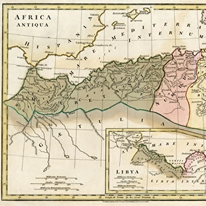
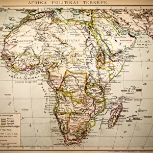
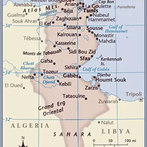
Map / Nw Africa 1719
North-west Africa, showing portions of Barbary, land of the Berbers, known to Europeans as barbarians (today Morocco, Tunisia &c)
Mary Evans Picture Library makes available wonderful images created for people to enjoy over the centuries
Media ID 4313297
© Mary Evans Picture Library 2015 - https://copyrighthub.org/s0/hub1/creation/maryevans/MaryEvansPictureID/10032393
1719 Barbarians Barbary Berbers Maps Morocco Portions Today Tunisia Europeans
Large Photo Mug (15 oz)
"Bring a piece of history to your morning routine with our Media Storehouse Photo Mugs. Featuring an exquisite image of "Map / Nw Africa 1719" by Rights Managed from Mary Evans Prints Online, these mugs showcase the intriguing details of North-west Africa, including portions of Barbary, the land of the Berbers once known to Europeans as barbarians (today's Morocco, Tunisia, and more). Each mug holds your favorite beverage and serves as a unique conversation starter. Order yours today and start your day with a touch of history in your hands."
Elevate your coffee or tea experience with our premium white ceramic mug. Its wide, comfortable handle makes drinking easy, and you can rely on it to be both microwave and dishwasher safe. Sold in single units, preview may show both sides of the same mug so you can see how the picture wraps around.
Elevate your coffee or tea experience with our premium white ceramic mug. Its wide, comfortable handle makes drinking easy, and you can rely on it to be both microwave and dishwasher safe. Sold in single units, preview may show both sides of the same mug so you can see how the picture wraps around.
These are individually made so all sizes are approximate
FEATURES IN THESE COLLECTIONS
> Africa
> Morocco
> Related Images
> Africa
> Related Images
> Africa
> Tunisia
> Related Images
> Europe
> France
> Canton
> Landes
> Europe
> Related Images
> Maps and Charts
> Early Maps
> Maps and Charts
> Related Images
EDITORS COMMENTS
This stunning print of a map from 1719 showcases the historical region of North-west Africa, known to Europeans as Barbary. The land of the Berbers, who were often labeled as barbarians by outsiders, is depicted in intricate detail on this piece. Today, these territories correspond to modern-day Morocco and Tunisia.
The map provides a fascinating glimpse into the past, offering insights into the geographical boundaries and political landscape of the region during that time period. It serves as a valuable historical artifact that sheds light on how Europeans perceived and interacted with North-west Africa centuries ago.
The intricate design and rich colors of this map make it a visually captivating piece that would be a striking addition to any collection or display. Whether you are a history buff, geography enthusiast, or simply appreciate fine artistry, this print is sure to spark curiosity and conversation.
Explore the nuances of North-west Africa's history through this meticulously crafted map from 1719. Gain a deeper understanding of the interactions between different cultures and civilizations in this region while admiring the beauty and complexity of cartography from centuries past.
MADE IN THE USA
Safe Shipping with 30 Day Money Back Guarantee
FREE PERSONALISATION*
We are proud to offer a range of customisation features including Personalised Captions, Color Filters and Picture Zoom Tools
SECURE PAYMENTS
We happily accept a wide range of payment options so you can pay for the things you need in the way that is most convenient for you
* Options may vary by product and licensing agreement. Zoomed Pictures can be adjusted in the Cart.