Metal Print > Asia > Iran > Lakes > Caspian Sea
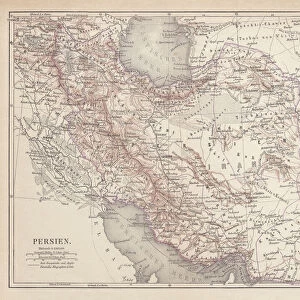
Metal Print : Map of Persia (Iran)
")

![]()
Metal Prints from Mary Evans Picture Library
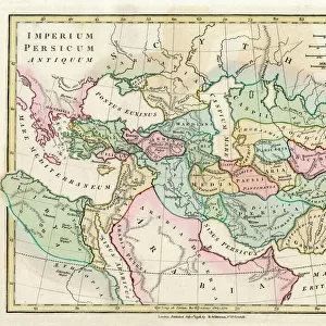
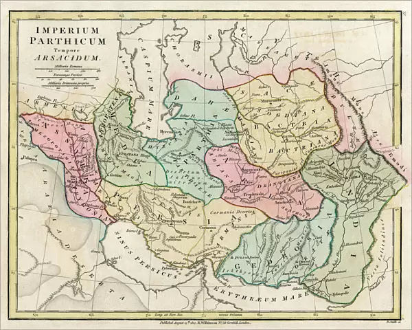
Map of Persia (Iran)
Map of Persia (Iran) - all place names in their Latin form. The ancient realms of Assyria, Babylonia Date: 1807
Mary Evans Picture Library makes available wonderful images created for people to enjoy over the centuries
Media ID 11575331
© Mary Evans / Grenville Collins Postcard Collection
1807 Caspian Chart Delta Gulf Indus Iran Iranian Maps Persia Persian Scales Silk Aral
16"x20" (51x41cm) Metal Print
Discover the rich history and cultural depth of Persia (Iran) with our stunning Metal Prints from Media Storehouse. This exquisite piece features an antique map of Persia, dating back to 1807, obtained from Mary Evans Prints Online. The map showcases the ancient realms of Assyria and Babylonia, with all place names in their Latin form. Bring history into your home or office with this unique and captivating decorative piece. Our high-quality Metal Prints are known for their vibrant colors, long-lasting durability, and sleek modern design. Order yours today and let the story of Persia unfold in your space.
Made with durable metal and luxurious printing techniques, our metal photo prints go beyond traditional canvases, adding a cool, modern touch to your space. Wall mount on back. Eco-friendly 100% post-consumer recycled ChromaLuxe aluminum surface. The thickness of the print is 0.045". Featuring a Scratch-resistant surface and Rounded corners. Backing hangers are attached to the back of the print and float the print 1/2-inch off the wall when hung, the choice of hanger may vary depending on size and International orders will come with Float Mount hangers only. Finished with a brilliant white high gloss surface for unsurpassed detail and vibrance. Printed using Dye-Sublimation and for best care we recommend a non-ammonia glass cleaner, water, or isopropyl (rubbing) alcohol to prevent harming the print surface. We recommend using a clean, lint-free cloth to wipe off the print. The ultra-hard surface is scratch-resistant, waterproof and weatherproof. Avoid direct sunlight exposure.
Made with durable metal and luxurious printing techniques, metal prints bring images to life and add a modern touch to any space
Estimated Image Size (if not cropped) is 50.8cm x 40.6cm (20" x 16")
Estimated Product Size is 51.4cm x 41.2cm (20.2" x 16.2")
These are individually made so all sizes are approximate
Artwork printed orientated as per the preview above, with landscape (horizontal) orientation to match the source image.
FEATURES IN THESE COLLECTIONS
> Asia
> India
> Related Images
> Asia
> Iran
> Lakes
> Caspian Sea
> Asia
> Iran
> Related Images
> Maps and Charts
> Early Maps
> Maps and Charts
> India
> Maps and Charts
> Related Images
EDITORS COMMENTS
This map print, hailing from the year 1807, offers a glimpse into the rich historical tapestry of the ancient world, specifically focusing on the Persian Empire and its neighboring regions. The map, titled "Persia, Caspian Sea, etc.," is a testament to the intricate complexities of geography and history that once shaped the Middle East. At the heart of the map lies the vast expanse of the Persian Empire, with its major cities and territories meticulously labeled in their Latin forms. The empire stretches from the Caspian Sea in the north to the Arabian Gulf in the south, encompassing modern-day Iran and parts of Central Asia. The Indus Delta, located in present-day Pakistan, is also depicted, marking the easternmost extent of the map. The ancient realms of Assyria and Babylonia are also highlighted, providing context to the map's historical significance. The Silk Road, a crucial trade route that connected the East and the West, is clearly marked, emphasizing the importance of Persia as a cultural and economic hub. The map's intricate details extend to the inclusion of bodies of water, such as the Aral Sea, and various gulf and delta regions. A key and scales are provided for reference, allowing viewers to navigate the map with ease. This map serves as a fascinating window into the past, offering a visual representation of the historical landscape that once was. Its intricate details and historical significance make it an essential addition to any collection focused on ancient history, cartography, or the Middle East.
MADE IN THE USA
Safe Shipping with 30 Day Money Back Guarantee
FREE PERSONALISATION*
We are proud to offer a range of customisation features including Personalised Captions, Color Filters and Picture Zoom Tools
SECURE PAYMENTS
We happily accept a wide range of payment options so you can pay for the things you need in the way that is most convenient for you
* Options may vary by product and licensing agreement. Zoomed Pictures can be adjusted in the Cart.