Photo Mug > Asia > Iran > Lakes > Caspian Sea
Photo Mug : Map of Persia (Iran)
")
")
![]()
Home Decor from Mary Evans Picture Library
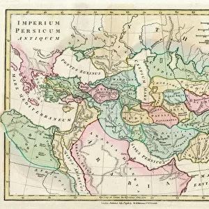
Map of Persia (Iran)
Map of Persia (Iran) - all place names in their Latin form. The ancient realms of Assyria, Babylonia Date: 1807
Mary Evans Picture Library makes available wonderful images created for people to enjoy over the centuries
Media ID 11575331
© Mary Evans / Grenville Collins Postcard Collection
1807 Caspian Chart Delta Gulf Indus Iran Iranian Maps Persia Persian Scales Silk Aral
Large Photo Mug (15 oz)
"Bring the rich history of Persia (Iran) right to your morning coffee with our Media Storehouse Photo Mugs. Featuring an exquisite, rights-managed map of Persia from Mary Evans Prints Online, dating back to 1807, this mug showcases the ancient realms of Assyria and Babylonia with all place names in their Latin form. Each mug is expertly printed with high-quality, vibrant images, ensuring your daily brew comes with a touch of history and culture. Perfect for history enthusiasts, travelers, or anyone who appreciates the beauty of the past, these Photo Mugs make a unique and thoughtful gift."
Elevate your coffee or tea experience with our premium white ceramic mug. Its wide, comfortable handle makes drinking easy, and you can rely on it to be both microwave and dishwasher safe. Sold in single units, preview may show both sides of the same mug so you can see how the picture wraps around.
Elevate your coffee or tea experience with our premium white ceramic mug. Its wide, comfortable handle makes drinking easy, and you can rely on it to be both microwave and dishwasher safe. Sold in single units, preview may show both sides of the same mug so you can see how the picture wraps around.
These are individually made so all sizes are approximate
FEATURES IN THESE COLLECTIONS
> Asia
> India
> Related Images
> Asia
> Iran
> Lakes
> Caspian Sea
> Asia
> Iran
> Related Images
> Maps and Charts
> Early Maps
> Maps and Charts
> India
> Maps and Charts
> Related Images
EDITORS COMMENTS
This map print, hailing from the year 1807, offers a glimpse into the rich historical tapestry of the ancient world, specifically focusing on the Persian Empire and its neighboring regions. The map, titled "Persia, Caspian Sea, etc.," is a testament to the intricate complexities of geography and history that once shaped the Middle East. At the heart of the map lies the vast expanse of the Persian Empire, with its major cities and territories meticulously labeled in their Latin forms. The empire stretches from the Caspian Sea in the north to the Arabian Gulf in the south, encompassing modern-day Iran and parts of Central Asia. The Indus Delta, located in present-day Pakistan, is also depicted, marking the easternmost extent of the map. The ancient realms of Assyria and Babylonia are also highlighted, providing context to the map's historical significance. The Silk Road, a crucial trade route that connected the East and the West, is clearly marked, emphasizing the importance of Persia as a cultural and economic hub. The map's intricate details extend to the inclusion of bodies of water, such as the Aral Sea, and various gulf and delta regions. A key and scales are provided for reference, allowing viewers to navigate the map with ease. This map serves as a fascinating window into the past, offering a visual representation of the historical landscape that once was. Its intricate details and historical significance make it an essential addition to any collection focused on ancient history, cartography, or the Middle East.
MADE IN THE USA
Safe Shipping with 30 Day Money Back Guarantee
FREE PERSONALISATION*
We are proud to offer a range of customisation features including Personalised Captions, Color Filters and Picture Zoom Tools
SECURE PAYMENTS
We happily accept a wide range of payment options so you can pay for the things you need in the way that is most convenient for you
* Options may vary by product and licensing agreement. Zoomed Pictures can be adjusted in the Cart.