Metal Print > Europe > United Kingdom > England > Maps
Metal Print : Map of St Pauls and area


![]()
Metal Prints from Mary Evans Picture Library
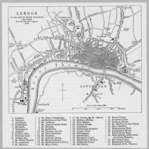
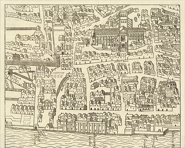
Map of St Pauls and area
Map of St. Pauls area, from Agass plan
Mary Evans Picture Library makes available wonderful images created for people to enjoy over the centuries
Media ID 583359
© Mary Evans Picture Library 2015 - https://copyrighthub.org/s0/hub1/creation/maryevans/MaryEvansPictureID/10032867
16"x20" (51x41cm) Metal Print
Discover the historic charm of St. Paul's area with our stunning Metal Prints from Media Storehouse, featuring this intricately detailed Map of St. Paul's from Mary Evans Picture Library. This Agass plan, showcasing the iconic landmarks and streets of this vibrant London district, is brought to life with our premium metal printing process. Each print is meticulously crafted to deliver brilliant colors, sharp lines, and a stunningly realistic 3D effect. Hang it in your home or office to add a touch of history and sophistication to any space.
Made with durable metal and luxurious printing techniques, our metal photo prints go beyond traditional canvases, adding a cool, modern touch to your space. Wall mount on back. Eco-friendly 100% post-consumer recycled ChromaLuxe aluminum surface. The thickness of the print is 0.045". Featuring a Scratch-resistant surface and Rounded corners. Backing hangers are attached to the back of the print and float the print 1/2-inch off the wall when hung, the choice of hanger may vary depending on size and International orders will come with Float Mount hangers only. Finished with a brilliant white high gloss surface for unsurpassed detail and vibrance. Printed using Dye-Sublimation and for best care we recommend a non-ammonia glass cleaner, water, or isopropyl (rubbing) alcohol to prevent harming the print surface. We recommend using a clean, lint-free cloth to wipe off the print. The ultra-hard surface is scratch-resistant, waterproof and weatherproof. Avoid direct sunlight exposure.
Made with durable metal and luxurious printing techniques, metal prints bring images to life and add a modern touch to any space
Estimated Image Size (if not cropped) is 50.8cm x 40.6cm (20" x 16")
Estimated Product Size is 51.4cm x 41.2cm (20.2" x 16.2")
These are individually made so all sizes are approximate
Artwork printed orientated as per the preview above, with landscape (horizontal) orientation to match the source image.
FEATURES IN THESE COLLECTIONS
> Mary Evans Prints Online
> Maps
> Europe
> United Kingdom
> England
> Maps
> Maps and Charts
> Early Maps
> Maps and Charts
> Related Images
EDITORS COMMENTS
This stunning antique map print, titled "Map of St. Paul's Area, from Agas Plan," offers a captivating glimpse into the historical layout of the St. Paul's area in London during the late 16th century. Dating back to approximately 1550, this map provides an intriguing perspective on the urban development of the English capital during the Tudor period. The map, produced by the renowned English cartographer and engraver, Christopher Saxton, under the supervision of George Agas, is an essential addition to any collection focusing on London's rich history. The meticulously detailed illustration showcases the bustling streets and landmarks of the St. Paul's area, including St. Paul's Cathedral, the River Thames, and various other churches, markets, and residences. The map's intricate design reveals the complex network of streets and alleys that crisscrossed the area, providing insight into the daily lives of its inhabitants. The inclusion of various symbols, such as the Star of David denoting a Jewish residence, and the Maltese Cross representing a leper house, adds depth to the historical context. This map not only serves as a testament to the cartographic prowess of the time but also offers a visual representation of the historical significance of St. Paul's area in London's development. The intricate details and historical accuracy make this map an invaluable resource for historians, urban planners, and anyone with an interest in London's rich history. The print's age, coupled with its detailed and accurate representation of the St. Paul's area during the Tudor period, makes it a captivating and visually stunning addition to any home or office, serving as a reminder of the intriguing history that lies beneath the modern-day streets of London.
MADE IN THE USA
Safe Shipping with 30 Day Money Back Guarantee
FREE PERSONALISATION*
We are proud to offer a range of customisation features including Personalised Captions, Color Filters and Picture Zoom Tools
SECURE PAYMENTS
We happily accept a wide range of payment options so you can pay for the things you need in the way that is most convenient for you
* Options may vary by product and licensing agreement. Zoomed Pictures can be adjusted in the Cart.