Poster Print > Europe > United Kingdom > England > Maps
Poster Print : Map of St Pauls and area


![]()
Poster Prints from Mary Evans Picture Library
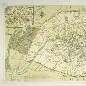
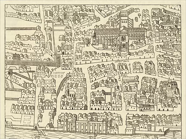
Map of St Pauls and area
Map of St. Pauls area, from Agass plan
Mary Evans Picture Library makes available wonderful images created for people to enjoy over the centuries
Media ID 583359
© Mary Evans Picture Library 2015 - https://copyrighthub.org/s0/hub1/creation/maryevans/MaryEvansPictureID/10032867
18x24 inch Poster Print
Introducing the stunning "Map of St. Paul's and Area" print from our Media Storehouse collection, brought to you in partnership with Mary Evans Picture Library. This captivating poster showcases an intriguing historical map of St. Paul's area, as depicted in the Agass plan. Delve into the rich history of this iconic London landmark with this beautifully detailed and authentic reproduction, perfect for adding a touch of historical charm to any room in your home or office. Immerse yourself in the story of St. Paul's and its surrounding areas with this exquisite poster print. Order yours today and let the history come alive in your space.
Poster prints are budget friendly enlarged prints in standard poster paper sizes. Printed on 150 gsm Matte Paper for a natural feel and supplied rolled in a tube. Great for framing and should last many years. To clean wipe with a microfiber, non-abrasive cloth or napkin. Our Archival Quality Photo Prints and Fine Art Paper Prints are printed on higher quality paper and the choice of which largely depends on your budget.
Poster prints are budget friendly enlarged prints in standard poster paper sizes (A0, A1, A2, A3 etc). Whilst poster paper is sometimes thinner and less durable than our other paper types, they are still ok for framing and should last many years. Our Archival Quality Photo Prints and Fine Art Paper Prints are printed on higher quality paper and the choice of which largely depends on your budget.
Estimated Product Size is 61.6cm x 46.3cm (24.3" x 18.2")
These are individually made so all sizes are approximate
Artwork printed orientated as per the preview above, with landscape (horizontal) orientation to match the source image.
FEATURES IN THESE COLLECTIONS
> Mary Evans Prints Online
> Maps
> Europe
> United Kingdom
> England
> Maps
> Maps and Charts
> Early Maps
> Maps and Charts
> Related Images
EDITORS COMMENTS
This stunning antique map print, titled "Map of St. Paul's Area, from Agas Plan," offers a captivating glimpse into the historical layout of the St. Paul's area in London during the late 16th century. Dating back to approximately 1550, this map provides an intriguing perspective on the urban development of the English capital during the Tudor period. The map, produced by the renowned English cartographer and engraver, Christopher Saxton, under the supervision of George Agas, is an essential addition to any collection focusing on London's rich history. The meticulously detailed illustration showcases the bustling streets and landmarks of the St. Paul's area, including St. Paul's Cathedral, the River Thames, and various other churches, markets, and residences. The map's intricate design reveals the complex network of streets and alleys that crisscrossed the area, providing insight into the daily lives of its inhabitants. The inclusion of various symbols, such as the Star of David denoting a Jewish residence, and the Maltese Cross representing a leper house, adds depth to the historical context. This map not only serves as a testament to the cartographic prowess of the time but also offers a visual representation of the historical significance of St. Paul's area in London's development. The intricate details and historical accuracy make this map an invaluable resource for historians, urban planners, and anyone with an interest in London's rich history. The print's age, coupled with its detailed and accurate representation of the St. Paul's area during the Tudor period, makes it a captivating and visually stunning addition to any home or office, serving as a reminder of the intriguing history that lies beneath the modern-day streets of London.
MADE IN THE USA
Safe Shipping with 30 Day Money Back Guarantee
FREE PERSONALISATION*
We are proud to offer a range of customisation features including Personalised Captions, Color Filters and Picture Zoom Tools
SECURE PAYMENTS
We happily accept a wide range of payment options so you can pay for the things you need in the way that is most convenient for you
* Options may vary by product and licensing agreement. Zoomed Pictures can be adjusted in the Cart.