Metal Print > Arts > Artists > R > Roman Roman
Metal Print : Roman Stations Map


![]()
Metal Prints from Mary Evans Picture Library
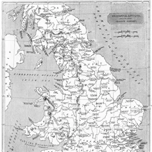
Roman Stations Map
A map depicting the network of Roman settlements in Britain
Mary Evans Picture Library makes available wonderful images created for people to enjoy over the centuries
Media ID 609913
© Mary Evans Picture Library 2015 - https://copyrighthub.org/s0/hub1/creation/maryevans/MaryEvansPictureID/10117078
Depicting Maps Net Work Settlements Stations
16"x20" (51x41cm) Metal Print
Discover the rich history of Roman Britain with our stunning Metal Prints from Media Storehouse, featuring the captivating Roman Stations Map by Mary Evans Picture Library from Mary Evans Prints Online. This intricately detailed map showcases the extensive network of Roman settlements that once thrived across the island. Each Metal Print is meticulously crafted with a high-definition image transferred onto a sturdy aluminum sheet, ensuring vibrant colors and exceptional durability. Bring history to life in your home or office with this unique and eye-catching decor piece. Order yours today and step back in time to the era of the mighty Roman Empire.
Made with durable metal and luxurious printing techniques, our metal photo prints go beyond traditional canvases, adding a cool, modern touch to your space. Wall mount on back. Eco-friendly 100% post-consumer recycled ChromaLuxe aluminum surface. The thickness of the print is 0.045". Featuring a Scratch-resistant surface and Rounded corners. Backing hangers are attached to the back of the print and float the print 1/2-inch off the wall when hung, the choice of hanger may vary depending on size and International orders will come with Float Mount hangers only. Finished with a brilliant white high gloss surface for unsurpassed detail and vibrance. Printed using Dye-Sublimation and for best care we recommend a non-ammonia glass cleaner, water, or isopropyl (rubbing) alcohol to prevent harming the print surface. We recommend using a clean, lint-free cloth to wipe off the print. The ultra-hard surface is scratch-resistant, waterproof and weatherproof. Avoid direct sunlight exposure.
Made with durable metal and luxurious printing techniques, metal prints bring images to life and add a modern touch to any space
Estimated Image Size (if not cropped) is 40.6cm x 50.8cm (16" x 20")
Estimated Product Size is 41.2cm x 51.4cm (16.2" x 20.2")
These are individually made so all sizes are approximate
Artwork printed orientated as per the preview above, with portrait (vertical) orientation to match the source image.
FEATURES IN THESE COLLECTIONS
> Arts
> Artists
> R
> Roman Roman
> Maps and Charts
> Early Maps
> Maps and Charts
> Related Images
EDITORS COMMENTS
This stunning print showcases a detailed Roman Stations Map, depicting the extensive network of Roman settlements in Britain. The intricate design and historical significance of this map provide a fascinating glimpse into the ancient world and the vast empire that once ruled over these lands.
Dating back to circa ancient times, this map offers a unique perspective on how the Romans established their presence in Britain through a series of strategically placed stations and settlements. Each point on the map tells a story of conquest, trade, and cultural exchange that shaped the landscape of Britain during this period.
The craftsmanship and attention to detail in this print are truly remarkable, capturing the essence of Roman engineering and urban planning. From bustling cities to remote outposts, every corner of Britain is meticulously documented on this map, offering viewers a glimpse into the past like never before.
Whether you're a history buff or simply appreciate fine artistry, this Roman Stations Map is sure to captivate your imagination and transport you back in time to an era when emperors reigned supreme and legions marched across distant lands. Add this piece from Mary Evans Picture Library to your collection today and bring a piece of ancient history into your home.
MADE IN THE USA
Safe Shipping with 30 Day Money Back Guarantee
FREE PERSONALISATION*
We are proud to offer a range of customisation features including Personalised Captions, Color Filters and Picture Zoom Tools
SECURE PAYMENTS
We happily accept a wide range of payment options so you can pay for the things you need in the way that is most convenient for you
* Options may vary by product and licensing agreement. Zoomed Pictures can be adjusted in the Cart.