Metal Print > Europe > Republic of Ireland > Maps
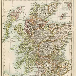
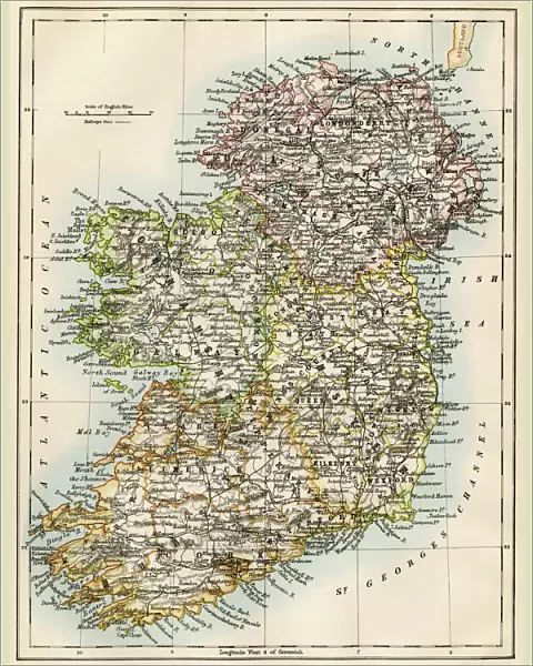
Metal Print : Ireland map, 1870s


Metal Prints from North Wind
Ireland map, 1870s
Map of Ireland, or Eire, 1870s.
Printed color lithograph
North Wind Picture Archives brings history to life with stock images and hand-colored illustrations
Media ID 5879186
© North Wind Picture Archives
1870s British Isles Eire Europe European Great Britain Ireland Irish Territory
16"x20" (51x41cm) Metal Print
Discover the charm of Ireland's past with our stunning Metal Print featuring an 1870s map of the emerald isle from North Wind Picture Archives. This captivating, vintage map of Ireland, or Eire, is brought to life through our unique metal printing process, which creates vibrant colors and a three-dimensional effect. Transport yourself back in time as the intricate details of this color lithograph map come to life on your wall. A perfect addition to any home or office, this Ireland map metal print is a conversation starter and a beautiful reminder of the rich history and culture of this beloved country.
Made with durable metal and luxurious printing techniques, our metal photo prints go beyond traditional canvases, adding a cool, modern touch to your space. Wall mount on back. Eco-friendly 100% post-consumer recycled ChromaLuxe aluminum surface. The thickness of the print is 0.045". Featuring a Scratch-resistant surface and Rounded corners. Backing hangers are attached to the back of the print and float the print 1/2-inch off the wall when hung, the choice of hanger may vary depending on size and International orders will come with Float Mount hangers only. Finished with a brilliant white high gloss surface for unsurpassed detail and vibrance. Printed using Dye-Sublimation and for best care we recommend a non-ammonia glass cleaner, water, or isopropyl (rubbing) alcohol to prevent harming the print surface. We recommend using a clean, lint-free cloth to wipe off the print. The ultra-hard surface is scratch-resistant, waterproof and weatherproof. Avoid direct sunlight exposure.
Made with durable metal and luxurious printing techniques, metal prints bring images to life and add a modern touch to any space
Estimated Image Size (if not cropped) is 40.6cm x 50.8cm (16" x 20")
Estimated Product Size is 41.2cm x 51.4cm (16.2" x 20.2")
These are individually made so all sizes are approximate
Artwork printed orientated as per the preview above, with portrait (vertical) orientation to match the source image.
FEATURES IN THESE COLLECTIONS
> Europe
> Republic of Ireland
> Maps
> Europe
> United Kingdom
> Maps
> Maps and Charts
> Related Images
> Popular Themes
> Maps and Charts
> North Wind Picture Archives
> British history
> North Wind Picture Archives
> Maps
EDITORS COMMENTS
This print showcases a stunning map of Ireland, dating back to the 1870s. The intricate details and vibrant colors bring this vintage lithograph to life, allowing us to delve into the rich history and heritage of this enchanting island. The map depicts the entire territory of Ireland, also known as Eire, during a significant period in its past. Every contour and boundary is meticulously illustrated, offering a glimpse into the political landscape of that time. This piece serves as an invaluable resource for historians and enthusiasts alike who seek to understand the evolution of Irish geography. As we explore this remarkable artwork, we are transported back to an era when Great Britain's influence loomed large over Ireland. It reminds us of the complex relationship between these two nations throughout history. Beyond its historical significance, this print is also a work of art in itself. The skillful use of printed color lithography brings out every nuance and detail with precision and beauty. Its presence on any wall would undoubtedly add elegance and sophistication while serving as a conversation starter for those intrigued by European culture. Whether you have ancestral ties or simply appreciate Irish culture, this print provides a window into Ireland's past like no other medium can offer. It encapsulates not only the geographical features but also reflects upon centuries-old traditions that continue to shape modern-day Eire – making it an invaluable addition to any collection celebrating British Isles' history or European heritage overall.
MADE IN THE USA
Safe Shipping with 30 Day Money Back Guarantee
FREE PERSONALISATION*
We are proud to offer a range of customisation features including Personalised Captions, Color Filters and Picture Zoom Tools
SECURE PAYMENTS
We happily accept a wide range of payment options so you can pay for the things you need in the way that is most convenient for you
* Options may vary by product and licensing agreement. Zoomed Pictures can be adjusted in the Cart.