Metal Print > Animals > Mammals > Delphinidae > Australis
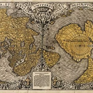
Metal Print : 16th century world map


![]()
Metal Prints from Science Photo Library
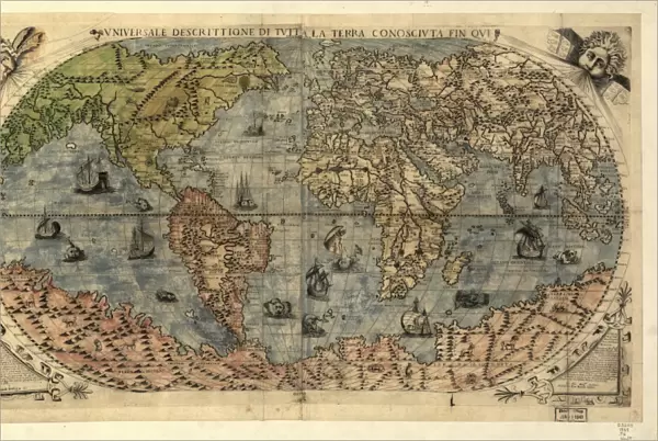
16th century world map
World map, published around 1565 in Venice, Italy, by Italian mapmaker Ferando Bertelli. The title of the map: Universale Descrittione di Tutta la Terra Conosciuta Fin Qui (universal description to the end of the known Earth). In the past few hundred years, the Americas (left) and the sea passage to India around Africa, and the islands of South-East Asia, had all been discovered, but these regions remained poorly mapped. This map shows a vast and unknown continent to the south, and Australia has not yet been discovered. Illustrations of ships and strange sea creatures are seen on the oceans, and strange animals are seen on the unknown lands. The winds are represented at upper right and left
Science Photo Library features Science and Medical images including photos and illustrations
Media ID 6349515
© LIBRARY OF CONGRESS, GEOGRAPHY AND MAP DIVISION/SCIENCE PHOTO LIBRARY
1500s 16th Century Africa America Ancient Cartography Continent Continents Diagram Eurasia Illustrated Inaccurate Incomplete Italian New World Old World Renaissance World 1565 Library Of Congress Terra Australis
16"x24" (61x41cm) Metal Print
Discover the rich history of cartography with our Media Storehouse Metal Prints featuring this stunning 16th century world map. Published around 1565 in Venice, Italy, by renowned mapmaker Ferando Bertelli, this Universale Descrittione di Tutta la Terra Conosciuta Fin Qui map showcases intricate details of the known world at the time. Our high-quality Metal Prints bring the vibrant colors and intricate lines of this historical masterpiece to life, making it a captivating addition to any home or office decor. Relive the exploration and discovery of the past with this beautiful piece of cartographic history.
Made with durable metal and luxurious printing techniques, our metal photo prints go beyond traditional canvases, adding a cool, modern touch to your space. Wall mount on back. Eco-friendly 100% post-consumer recycled ChromaLuxe aluminum surface. The thickness of the print is 0.045". Featuring a Scratch-resistant surface and Rounded corners. Backing hangers are attached to the back of the print and float the print 1/2-inch off the wall when hung, the choice of hanger may vary depending on size and International orders will come with Float Mount hangers only. Finished with a brilliant white high gloss surface for unsurpassed detail and vibrance. Printed using Dye-Sublimation and for best care we recommend a non-ammonia glass cleaner, water, or isopropyl (rubbing) alcohol to prevent harming the print surface. We recommend using a clean, lint-free cloth to wipe off the print. The ultra-hard surface is scratch-resistant, waterproof and weatherproof. Avoid direct sunlight exposure.
Made with durable metal and luxurious printing techniques, metal prints bring images to life and add a modern touch to any space
Estimated Product Size is 61.5cm x 41.2cm (24.2" x 16.2")
These are individually made so all sizes are approximate
Artwork printed orientated as per the preview above, with landscape (horizontal) orientation to match the source image.
FEATURES IN THESE COLLECTIONS
> Africa
> South Africa
> Maps
> Africa
> South Africa
> Related Images
> Animals
> Mammals
> Cricetidae
> Australis
> Animals
> Mammals
> Delphinidae
> Australis
> Animals
> Mammals
> Molossidae
> Australis
> Arts
> Art Movements
> Renaissance Art
> Arts
> Artists
> O
> Oceanic Oceanic
> Asia
> India
> Related Images
> Maps and Charts
> Popular Maps
EDITORS COMMENTS
This 16th-century world map, published in Venice by Italian mapmaker Ferando Bertelli around 1565, offers a fascinating glimpse into the state of geographical knowledge during the Renaissance era. Titled "Universale Descrittione di Tutta la Terra Conosciuta Fin Qui" (universal description to the end of the known Earth), it reflects an incomplete understanding of our planet's vastness and diversity. While regions such as Europe, Africa, and parts of Asia are relatively well-documented on this ancient artifact, significant gaps remain. The Americas appear on the left side but lack detailed mapping, while a mysterious southern continent looms large below. Notably absent is Australia, which had not yet been discovered at that time. The intricately illustrated oceans feature depictions of ships sailing through uncharted waters alongside fantastical sea creatures. On land, peculiar animals roam unfamiliar territories waiting to be explored and understood. Intriguingly, wind patterns are represented in the upper corners—a testament to early attempts at comprehending atmospheric dynamics. As we gaze upon this historical treasure from Science Photo Library's collection at the Library of Congress, we are reminded that human curiosity has always driven us to explore and unravel the mysteries surrounding our world. This remarkable piece serves as a reminder of how far we have come in charting our planet's geography since those times when maps were filled with both accuracy and imagination.
MADE IN THE USA
Safe Shipping with 30 Day Money Back Guarantee
FREE PERSONALISATION*
We are proud to offer a range of customisation features including Personalised Captions, Color Filters and Picture Zoom Tools
SECURE PAYMENTS
We happily accept a wide range of payment options so you can pay for the things you need in the way that is most convenient for you
* Options may vary by product and licensing agreement. Zoomed Pictures can be adjusted in the Cart.