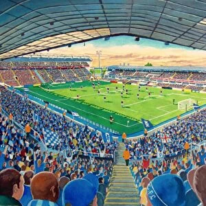
Metal Print > Europe > United Kingdom > England > Birmingham > Area > Browns Green
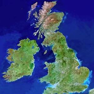
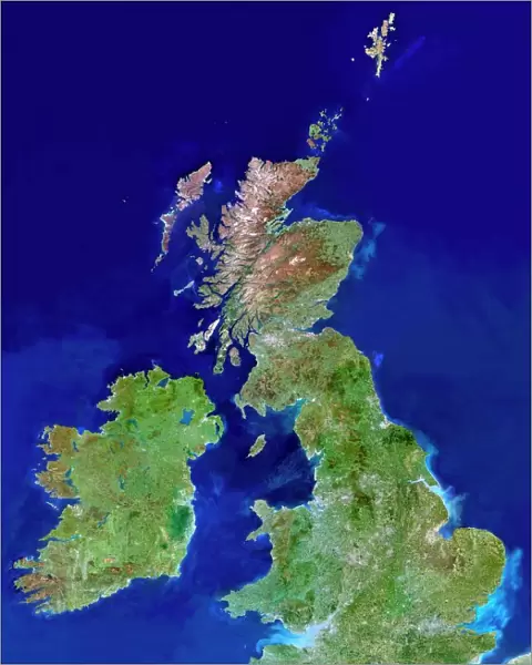
Metal Print : British Isles, satellite image


![]()
Metal Prints from Science Photo Library
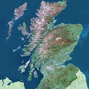
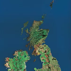
British Isles, satellite image
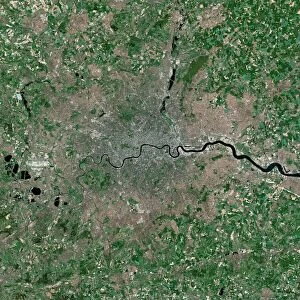
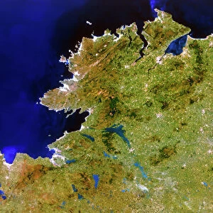
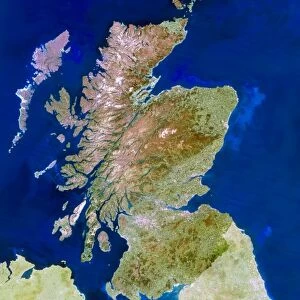
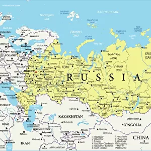
UK and Ireland. Satellite image of the UK and the Republic of Ireland (Eire). North is at top. Water is blue, vegetation is green, dry or barren areas are brown, and snow and ice are white. The Irish Sea lies between the UK mainland (right) and the island of Ireland and Northern Ireland (left). The North Sea is at upper right. The English Channel separates the UK from France (part of which is seen at bottom right). Shallow coastal areas are light blue. Major cities and other urban areas are grey patches. London (lower right), Birmingham (north-west of London), Glasgow (upper centre in Scotland, below the brown Highlands area) and Dublin (east coast of Ireland) are all seen
Science Photo Library features Science and Medical images including photos and illustrations
Media ID 6375983
© PLANETOBSERVER/SCIENCE PHOTO LIBRARY
British Isles Country Earth Observation Earth Science From Space Great Ireland Island Landsat 5 Northern Ireland Satellite Satellite Image Sciences Scot Land Wales
16"x20" (51x41cm) Metal Print
Discover the breathtaking beauty of the British Isles with our Media Storehouse Metal Prints. Featuring a stunning satellite image from Science Photo Library, this unique representation showcases the diverse landscapes of the UK and the Republic of Ireland in exquisite detail. With vibrant blues for the surrounding waters, lush greens for vegetation, and distinct browns for dry or barren areas, this captivating image is further enhanced by the contrasting white hues of snow and ice. Bring this awe-inspiring view into your home or office and elevate your decor with a modern and sophisticated metal print from Media Storehouse.
Made with durable metal and luxurious printing techniques, our metal photo prints go beyond traditional canvases, adding a cool, modern touch to your space. Wall mount on back. Eco-friendly 100% post-consumer recycled ChromaLuxe aluminum surface. The thickness of the print is 0.045". Featuring a Scratch-resistant surface and Rounded corners. Backing hangers are attached to the back of the print and float the print 1/2-inch off the wall when hung, the choice of hanger may vary depending on size and International orders will come with Float Mount hangers only. Finished with a brilliant white high gloss surface for unsurpassed detail and vibrance. Printed using Dye-Sublimation and for best care we recommend a non-ammonia glass cleaner, water, or isopropyl (rubbing) alcohol to prevent harming the print surface. We recommend using a clean, lint-free cloth to wipe off the print. The ultra-hard surface is scratch-resistant, waterproof and weatherproof. Avoid direct sunlight exposure.
Made with durable metal and luxurious printing techniques, metal prints bring images to life and add a modern touch to any space
Estimated Image Size (if not cropped) is 40.6cm x 50.8cm (16" x 20")
Estimated Product Size is 41.2cm x 51.4cm (16.2" x 20.2")
These are individually made so all sizes are approximate
Artwork printed orientated as per the preview above, with portrait (vertical) orientation to match the source image.
FEATURES IN THESE COLLECTIONS
> Animals
> Mammals
> Muridae
> Blue-grey Mouse
> Animals
> Mammals
> Muridae
> Water Mouse
> Europe
> France
> Canton
> Landes
> Europe
> Related Images
> Europe
> Republic of Ireland
> Dublin
> Europe
> Republic of Ireland
> Related Images
> Europe
> United Kingdom
> England
> Birmingham
> Area
> Birmingham City Centre
> Europe
> United Kingdom
> England
> Birmingham
> Area
> Browns Green
> Europe
> United Kingdom
> England
> Birmingham
> Related Images
> Europe
> United Kingdom
> England
> London
> Museums
> British Library
EDITORS COMMENTS
This satellite image showcases the stunning beauty of the British Isles, comprising the United Kingdom and Ireland. With its north-oriented perspective, this print offers a bird's-eye view of these enchanting lands. The vibrant blue hues depict the surrounding waters, including the Irish Sea that separates mainland UK from Ireland and Northern Ireland. Towards the upper right corner lies the vast North Sea. The distinct colors on this print provide valuable insights into various terrains: lush green represents abundant vegetation, while brown signifies dry or barren areas. Snow-capped peaks and icy expanses are depicted in pristine white. Notably, shallow coastal regions appear as light blue shades. As we explore this image further, grey patches emerge to represent major cities and urban areas across both countries. London stands out prominently in the lower right corner, with Birmingham positioned northwest of it. In Scotland's upper center lies Glasgow amidst a backdrop of majestic brown Highlands; Dublin graces Ireland's east coast. Captured by Landsat 5 satellite imagery technology, this photograph is not only visually striking but also serves as an invaluable tool for earth scientists studying our planet from space. Science Photo Library has expertly curated this remarkable snapshot of Europe's magnificent British Isles for all to appreciate their natural wonders and human settlements alike.
MADE IN THE USA
Safe Shipping with 30 Day Money Back Guarantee
FREE PERSONALISATION*
We are proud to offer a range of customisation features including Personalised Captions, Color Filters and Picture Zoom Tools
SECURE PAYMENTS
We happily accept a wide range of payment options so you can pay for the things you need in the way that is most convenient for you
* Options may vary by product and licensing agreement. Zoomed Pictures can be adjusted in the Cart.