Mouse Mat > Arts > Artists > S > Syrian Syrian
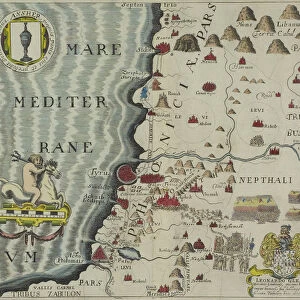
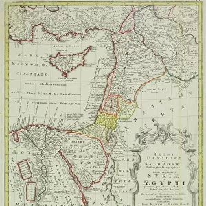
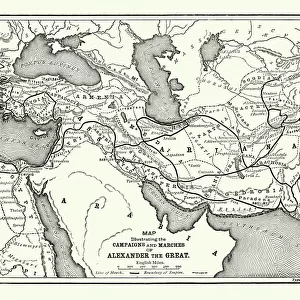
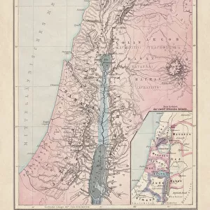
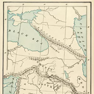
Mouse Mat : Antique map of holy land including Syria and Lebanon


![]()
Home Decor from Fine Art Storehouse
Antique map of holy land including Syria and Lebanon
Unleash your creativity and transform your space into a visual masterpiece!
Hemera Technologies
Media ID 13609443
© Getty Images
17th Century Compass Cyprus Damascus Direction Document Geography Historical Palestine Holy Land Island Lebanon Lebanon Country Legend Location Mediterranean Sea Navigational Compass Place Positioning Syria Sidon
Mouse Pad
Standard Size Mouse Pad 7.75" x 9..25". High density Neoprene w linen surface. Easy to clean, stain resistant finish. Rounded corners.
Archive quality photographic print in a durable wipe clean mouse mat with non slip backing. Works with all computer mice
Estimated Product Size is 23.7cm x 20.2cm (9.3" x 8")
These are individually made so all sizes are approximate
Artwork printed orientated as per the preview above, with landscape (horizontal) or portrait (vertical) orientation to match the source image.
FEATURES IN THESE COLLECTIONS
> Fine Art Storehouse
> Map
> Historical Maps
> Arts
> Artists
> S
> Syrian Syrian
> Asia
> Cyprus
> Related Images
> Asia
> Lebanon
> Related Images
> Asia
> Palestine
> Related Images
> Asia
> Syria
> Related Images
EDITORS COMMENTS
This 17th-century antique map of the Holy Land, including Syria and Lebanon, takes us on a journey through time. Crafted with meticulous detail by Hemera Technologies, this archival print showcases the artistry and precision of cartography from centuries past. As we gaze upon this vintage engraving, our eyes are drawn to the intricate compass rose at its center. Symbolizing exploration and discovery, it serves as a navigational guide for adventurers seeking to unravel the mysteries of these ancient lands. The map's vibrant colors transport us back in time, revealing the historical significance of each place it depicts. From Damascus to Sidon, from Cyprus to Jerusalem - every location holds stories waiting to be discovered. Lebanon's majestic mountains stand tall alongside its neighboring regions like Libanus et Ejus Vicinia. The Mediterranean Sea stretches out before us as a reminder of the region's rich maritime history. With no people present in this image, we are left solely with nature's beauty and historical remnants. This absence invites us to reflect on how much has changed since this map was first created – yet also reminds us that some things remain constant throughout history. This remarkable piece is not just an artwork but also a key that unlocks doors into our collective past. It allows us to explore physical geography while immersing ourselves in the fascinating world of historical Palestine. Let your imagination soar as you delve into this snapshot frozen in time by Hemera Technologies' photography expertise.
MADE IN THE USA
Safe Shipping with 30 Day Money Back Guarantee
FREE PERSONALISATION*
We are proud to offer a range of customisation features including Personalised Captions, Color Filters and Picture Zoom Tools
SECURE PAYMENTS
We happily accept a wide range of payment options so you can pay for the things you need in the way that is most convenient for you
* Options may vary by product and licensing agreement. Zoomed Pictures can be adjusted in the Cart.