Mouse Mat > Animals > Mammals > Muridae > House Mouse
Mouse Mat : Map of Europe


![]()
Home Decor from Fine Art Storehouse
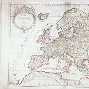
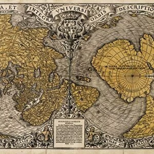
Map of Europe
Antique Maps of the World
Map of Europe
Nicolas Visscher
c 1658
Unleash your creativity and transform your space into a visual masterpiece!
The Map House of London
Media ID 14763523
© This content is subject to copyright
Mouse Pad
Standard Size Mouse Pad 7.75" x 9..25". High density Neoprene w linen surface. Easy to clean, stain resistant finish. Rounded corners.
Archive quality photographic print in a durable wipe clean mouse mat with non slip backing. Works with all computer mice
Estimated Image Size (if not cropped) is 23.7cm x 19.4cm (9.3" x 7.6")
Estimated Product Size is 23.7cm x 20.2cm (9.3" x 8")
These are individually made so all sizes are approximate
Artwork printed orientated as per the preview above, with landscape (horizontal) orientation to match the source image.
FEATURES IN THESE COLLECTIONS
> Fine Art Storehouse
> Map
> Historical Maps
> Animals
> Mammals
> Muridae
> House Mouse
> Maps and Charts
> Popular Maps
> Maps and Charts
> Related Images
> Maps and Charts
> World
EDITORS COMMENTS
This print showcases a true treasure from the past, an antique map of Europe created by Nicolas Visscher in approximately 1658. Brought to you by The Map House of London, this stunning piece offers a glimpse into the intricate cartographic artistry of centuries ago. The map itself is a testament to Visscher's skill and attention to detail. With delicate lines and exquisite hand coloring, it presents Europe as it was known during the mid-17th century. From the rugged coastlines of Scandinavia to the sun-drenched shores of Italy, every region is meticulously depicted with accuracy and precision. As we gaze upon this vintage masterpiece, we are transported back in time, imagining how Europeans once navigated their way through vast lands and unknown territories. It serves as a reminder of our rich history and cultural heritage that has shaped our present-day continent. The Map House of London has carefully preserved this remarkable artifact for all enthusiasts who appreciate both art and geography. By offering this photo print, they allow us to bring home a piece of history while adding an air of sophistication to any space. Whether displayed in your study or adorning your living room wall, this antique map invites exploration and sparks curiosity about the world that existed long before us. Let it be a conversation starter among friends or simply an elegant addition to your collection – either way, its timeless beauty will surely captivate all who behold it.
MADE IN THE USA
Safe Shipping with 30 Day Money Back Guarantee
FREE PERSONALISATION*
We are proud to offer a range of customisation features including Personalised Captions, Color Filters and Picture Zoom Tools
SECURE PAYMENTS
We happily accept a wide range of payment options so you can pay for the things you need in the way that is most convenient for you
* Options may vary by product and licensing agreement. Zoomed Pictures can be adjusted in the Cart.