Photographic Print > Animals > Mammals > Muridae > House Mouse
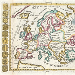
Photographic Print : Map of Europe


![]()
Photo Prints from Fine Art Storehouse
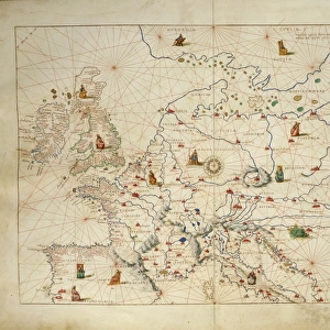
Map of Europe
Antique Maps of the World
Map of Europe
Nicolas Visscher
c 1658
Unleash your creativity and transform your space into a visual masterpiece!
The Map House of London
Media ID 14763523
© This content is subject to copyright
10"x8" Photo Print
Step back in time with our exquisite antique Map of Europe print from The Map House of London, available at Fine Art Storehouse. This stunning piece, created by renowned cartographer Nicolas Visscher around 1658, offers a captivating glimpse into the historical geography of Europe during the 17th century. With intricate detail and beautiful antique aesthetics, this print is not just a map - it's a window into the past. Bring the rich history and classic charm of old European cartography into your home or office with this fine art print from Media Storehouse.
Photo prints are produced on Kodak professional photo paper resulting in timeless and breath-taking prints which are also ideal for framing. The colors produced are rich and vivid, with accurate blacks and pristine whites, resulting in prints that are truly timeless and magnificent. Whether you're looking to display your prints in your home, office, or gallery, our range of photographic prints are sure to impress. Dimensions refers to the size of the paper in inches.
Our Photo Prints are in a large range of sizes and are printed on Archival Quality Paper for excellent colour reproduction and longevity. They are ideal for framing (our Framed Prints use these) at a reasonable cost. Alternatives include cheaper Poster Prints and higher quality Fine Art Paper, the choice of which is largely dependant on your budget.
Estimated Product Size is 25.4cm x 20.3cm (10" x 8")
These are individually made so all sizes are approximate
Artwork printed orientated as per the preview above, with landscape (horizontal) or portrait (vertical) orientation to match the source image.
FEATURES IN THESE COLLECTIONS
> Fine Art Storehouse
> Map
> Historical Maps
> Animals
> Mammals
> Muridae
> House Mouse
> Maps and Charts
> Popular Maps
> Maps and Charts
> Related Images
> Maps and Charts
> World
EDITORS COMMENTS
This print showcases a true treasure from the past, an antique map of Europe created by Nicolas Visscher in approximately 1658. Brought to you by The Map House of London, this stunning piece offers a glimpse into the intricate cartographic artistry of centuries ago. The map itself is a testament to Visscher's skill and attention to detail. With delicate lines and exquisite hand coloring, it presents Europe as it was known during the mid-17th century. From the rugged coastlines of Scandinavia to the sun-drenched shores of Italy, every region is meticulously depicted with accuracy and precision. As we gaze upon this vintage masterpiece, we are transported back in time, imagining how Europeans once navigated their way through vast lands and unknown territories. It serves as a reminder of our rich history and cultural heritage that has shaped our present-day continent. The Map House of London has carefully preserved this remarkable artifact for all enthusiasts who appreciate both art and geography. By offering this photo print, they allow us to bring home a piece of history while adding an air of sophistication to any space. Whether displayed in your study or adorning your living room wall, this antique map invites exploration and sparks curiosity about the world that existed long before us. Let it be a conversation starter among friends or simply an elegant addition to your collection – either way, its timeless beauty will surely captivate all who behold it.
MADE IN THE USA
Safe Shipping with 30 Day Money Back Guarantee
FREE PERSONALISATION*
We are proud to offer a range of customisation features including Personalised Captions, Color Filters and Picture Zoom Tools
SECURE PAYMENTS
We happily accept a wide range of payment options so you can pay for the things you need in the way that is most convenient for you
* Options may vary by product and licensing agreement. Zoomed Pictures can be adjusted in the Cart.