Mouse Mat > Europe > United Kingdom > England > London > Towns > Welling
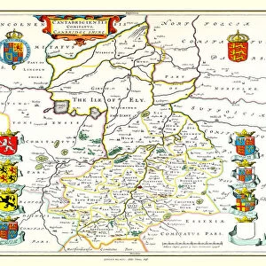
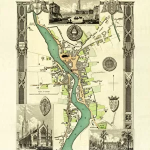
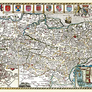
Mouse Mat : Old County Map of Cambridgeshire 1836 by Thomas Moule

![]()
Home Decor from MapSeeker
Old County Map of Cambridgeshire 1836 by Thomas Moule
This is a fine decorative reproduction County Map of Cambridgeshire from the First Edition series of Thomas Moule Maps, originally Published in 1836. The well-known series of County Maps which are known as Moules feature beautiful vignette views and were first published in separate sections for each county in 1830-32, they were then published in collected form in a two-volume work: The English Counties Delineated: or a Topographical Description of England: Illustrated by a Complete Series of County Maps by Thomas Moule: London: Published by George Virtue 1836
Welcome to the Mapseeker Image library and enter an historic gateway to one of the largest on-line collections of Historic Maps, Nostalgic Views, Vista's and Panorama's from a World gone by.
Media ID 20348136
© Mapseeker Publishing Ltd
County Map County Map Of England English County Map Historic Map Moule Map Old County Map Old English County Map Old Moule Map Thomas Moule Thomas Moule Map Cambridgeshire
Mouse Pad
Standard Size Mouse Pad 7.75" x 9..25". High density Neoprene w linen surface. Easy to clean, stain resistant finish. Rounded corners.
Archive quality photographic print in a durable wipe clean mouse mat with non slip backing. Works with all computer mice
Estimated Image Size (if not cropped) is 19.8cm x 23.7cm (7.8" x 9.3")
Estimated Product Size is 20.2cm x 23.7cm (8" x 9.3")
These are individually made so all sizes are approximate
Artwork printed orientated as per the preview above, with portrait (vertical) orientation to match the source image.
FEATURES IN THESE COLLECTIONS
> MapSeeker
> Maps from the British Isles
> England and Counties PORTFOLIO
> Arts
> Artists
> M
> Thomas Moule
> Europe
> United Kingdom
> England
> Cambridgeshire
> Related Images
> Europe
> United Kingdom
> England
> London
> Towns
> Welling
> Europe
> United Kingdom
> England
> Maps
> Europe
> United Kingdom
> England
> Wells
> Maps and Charts
> Early Maps
> Maps and Charts
> Related Images
EDITORS COMMENTS
This exquisite print showcases the "Old County Map of Cambridgeshire 1836" by Thomas Moule, a renowned cartographer of his time. Originally published as part of Moule's First Edition series in 1836, this decorative reproduction captures the historical charm and intricate details that make it a true collector's item. Moule's county maps are highly regarded for their stunning vignette views, which add an artistic touch to the topographical descriptions they provide. The map was initially released in sections for each county between 1830 and 1832 before being compiled into a two-volume work titled "The English Counties Delineated: or a Topographical Description of England". This particular edition was published by George Virtue in London in 1836. Cambridgeshire is beautifully depicted on this historic map, offering a glimpse into its past landscape and landmarks. As one explores the intricacies of Moule's creation, they can immerse themselves in the rich history and heritage that shaped this English county. Whether you're an avid collector, history enthusiast, or simply appreciate fine artistry, this print brings together both beauty and historical significance. It serves as a captivating reminder of how maps have evolved over time while preserving our connection to the past. Displaying this piece will undoubtedly spark conversations about Cambridgeshire's fascinating history and its place within England's diverse counties.
MADE IN THE USA
Safe Shipping with 30 Day Money Back Guarantee
FREE PERSONALISATION*
We are proud to offer a range of customisation features including Personalised Captions, Color Filters and Picture Zoom Tools
SECURE PAYMENTS
We happily accept a wide range of payment options so you can pay for the things you need in the way that is most convenient for you
* Options may vary by product and licensing agreement. Zoomed Pictures can be adjusted in the Cart.