Mouse Mat > Europe > United Kingdom > England > Yorkshire > Sheffield
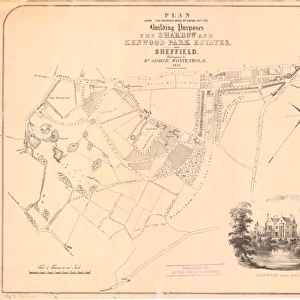
Mouse Mat : Plan of Sandbed Wheel held of the Earl of Surrey by the assignees of Thomas Broadbent, Neepsend, Sheffield, 1783


![]()
Home Decor from Sheffield City Archives
Plan of Sandbed Wheel held of the Earl of Surrey by the assignees of Thomas Broadbent, Neepsend, Sheffield, 1783
Scale: 2 chains : 1 inch [40 inches : 1 mile]
Surveyor: William Fairbank II.
Wheels, dam and goit clearly shown and named; numerical list with descriptions and acreages; height of fall given.
From an original at Sheffield Libraries: arc02739
Sheffield City Archives and Local Studies Library has an unrivalled collection of images of Sheffield, England
Media ID 18725130
© Sheffield City Council - All Rights Reserved
Maps Neepsend Plans River Don Sheffield Waterwheels Yorkshire
Mouse Pad
Standard Size Mouse Pad 7.75" x 9..25". High density Neoprene w linen surface. Easy to clean, stain resistant finish. Rounded corners.
Archive quality photographic print in a durable wipe clean mouse mat with non slip backing. Works with all computer mice
Estimated Image Size (if not cropped) is 23.7cm x 14.2cm (9.3" x 5.6")
Estimated Product Size is 23.7cm x 20.2cm (9.3" x 8")
These are individually made so all sizes are approximate
Artwork printed orientated as per the preview above, with landscape (horizontal) orientation to match the source image.
FEATURES IN THESE COLLECTIONS
> Europe
> United Kingdom
> England
> Surrey
> Related Images
> Europe
> United Kingdom
> England
> Yorkshire
> Related Images
> Europe
> United Kingdom
> England
> Yorkshire
> Sheffield
> Maps and Charts
> Related Images
> Sheffield City Archives
> Maps and Plans
> Maps of Sheffield
EDITORS COMMENTS
This print showcases the intricate "Plan of Sandbed Wheel" held by the Earl of Surrey in 1783. The assignees of Thomas Broadbent, hailing from Neepsend, Sheffield, meticulously documented this impressive structure. Surveyor William Fairbank II left no detail unnoticed as he accurately depicted the wheels, dam, and goit (water channel) with utmost precision. The scale of this plan is awe-inspiring - 2 chains to 1 inch or a staggering 40 inches to 1 mile! This level of accuracy allows viewers to grasp the grandeur and complexity of this engineering marvel. Each element is clearly labeled and named for easy identification. A numerical list accompanies the plan, providing detailed descriptions and acreages for each feature. What sets this print apart is its inclusion of vital information such as the height of fall. This crucial data sheds light on how water power was harnessed effectively at Sandbed Wheel during that era. Preserved within Sheffield Libraries' archives under reference arc02739, this historical gem offers a glimpse into Yorkshire's rich industrial heritage. It highlights not only technological advancements but also pays homage to those who built these remarkable structures along River Don
MADE IN THE USA
Safe Shipping with 30 Day Money Back Guarantee
FREE PERSONALISATION*
We are proud to offer a range of customisation features including Personalised Captions, Color Filters and Picture Zoom Tools
SECURE PAYMENTS
We happily accept a wide range of payment options so you can pay for the things you need in the way that is most convenient for you
* Options may vary by product and licensing agreement. Zoomed Pictures can be adjusted in the Cart.