Photo Mug > Maps and Charts > Related Images
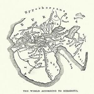
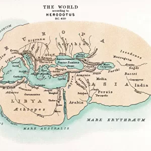
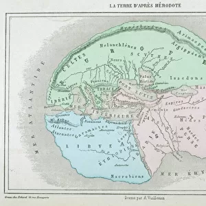
Photo Mug : Earth map according to Herodotus


Home Decor from Fine Art Storehouse
Earth map according to Herodotus
Antique illustration of a earth map according to Herodotus
Unleash your creativity and transform your space into a visual masterpiece!
Nastasic
Media ID 14756838
© This content is subject to copyright
Large Photo Mug (15 oz)
Introducing the Media Storehouse Photo Mug, a perfect blend of history and functionality. Featuring an exquisite antique illustration of an Earth map according to Herodotus by Nastasic from our Fine Art Storehouse collection, this mug is more than just a drinkware - it's a work of art. Each mug showcases the intriguing ancient cartography of Herodotus, transporting you back in time. The high-quality printing ensures that the vibrant colors and intricate details of the map are preserved, making every sip an adventure. Embrace the rich history and add a touch of antiquity to your daily routine. This unique and thoughtful gift is sure to impress anyone with an appreciation for history, art, or just a love for a good cup of coffee or tea. Order your Media Storehouse Photo Mug today and embark on a journey through time with every use.
Elevate your coffee or tea experience with our premium white ceramic mug. Its wide, comfortable handle makes drinking easy, and you can rely on it to be both microwave and dishwasher safe. Sold in single units, preview may show both sides of the same mug so you can see how the picture wraps around.
Elevate your coffee or tea experience with our premium white ceramic mug. Its wide, comfortable handle makes drinking easy, and you can rely on it to be both microwave and dishwasher safe. Sold in single units, preview may show both sides of the same mug so you can see how the picture wraps around.
These are individually made so all sizes are approximate
FEATURES IN THESE COLLECTIONS
> Fine Art Storehouse
> Map
> Historical Maps
> Maps and Charts
> Related Images
EDITORS COMMENTS
This print showcases an antique illustration of the Earth map according to Herodotus, created by the talented artist Nastasic. Stepping back in time, this artwork takes us on a journey through history and geography, offering a glimpse into how our world was perceived centuries ago. Herodotus, often hailed as the "Father of History" was an ancient Greek historian who meticulously documented his observations and knowledge about various cultures and lands. This particular depiction of the Earth map reflects his understanding during that era, providing us with valuable insights into early cartography. The intricate details captured in this print are truly awe-inspiring. The delicate lines delineating continents and oceans transport us to a time when exploration was at its infancy. Each stroke tells a story of discovery and curiosity about distant lands waiting to be explored. As we gaze upon this remarkable piece of art, we can't help but marvel at how far our understanding of the world has evolved since then. It serves as a reminder that knowledge is ever-evolving and that there is always more to learn about our planet's rich history. Whether you're an avid history enthusiast or simply appreciate fine art, this exquisite print will undoubtedly add depth and intrigue to any space it graces. Let it spark conversations about ancient civilizations, inspire wanderlust for uncharted territories, or serve as a testament to human curiosity throughout the ages - all within the confines of your own home or office.
MADE IN THE USA
Safe Shipping with 30 Day Money Back Guarantee
FREE PERSONALISATION*
We are proud to offer a range of customisation features including Personalised Captions, Color Filters and Picture Zoom Tools
SECURE PAYMENTS
We happily accept a wide range of payment options so you can pay for the things you need in the way that is most convenient for you
* Options may vary by product and licensing agreement. Zoomed Pictures can be adjusted in the Cart.