Poster Print > Maps and Charts > Related Images
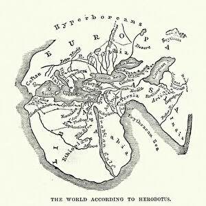
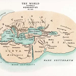
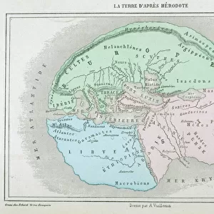
Poster Print : Earth map according to Herodotus


Poster Prints from Fine Art Storehouse
Earth map according to Herodotus
Antique illustration of a earth map according to Herodotus
Unleash your creativity and transform your space into a visual masterpiece!
Nastasic
Media ID 14756838
© This content is subject to copyright
18x24 inch Poster Print
Introducing the captivating "Earth Map according to Herodotus" by Nastasic, now available as a stunning poster print from Media Storehouse's Fine Art collection. This exquisite antique illustration transports you back in time, offering a fascinating glimpse into ancient geographical understanding. Herodotus of Halicarnassus, the renowned Greek historian, is believed to have compiled this map around 450 BC. The intricate details and vibrant colors bring to life the mythical lands and geographical features as they were once imagined. Add an air of history and intrigue to any room with this beautifully printed and preserved poster, a unique addition to your decor that tells a story of the past.
Poster prints are budget friendly enlarged prints in standard poster paper sizes. Printed on 150 gsm Matte Paper for a natural feel and supplied rolled in a tube. Great for framing and should last many years. To clean wipe with a microfiber, non-abrasive cloth or napkin. Our Archival Quality Photo Prints and Fine Art Paper Prints are printed on higher quality paper and the choice of which largely depends on your budget.
Poster prints are budget friendly enlarged prints in standard poster paper sizes (A0, A1, A2, A3 etc). Whilst poster paper is sometimes thinner and less durable than our other paper types, they are still ok for framing and should last many years. Our Archival Quality Photo Prints and Fine Art Paper Prints are printed on higher quality paper and the choice of which largely depends on your budget.
Estimated Product Size is 61.6cm x 46.3cm (24.3" x 18.2")
These are individually made so all sizes are approximate
Artwork printed orientated as per the preview above, with landscape (horizontal) orientation to match the source image.
FEATURES IN THESE COLLECTIONS
> Fine Art Storehouse
> Map
> Historical Maps
> Maps and Charts
> Related Images
EDITORS COMMENTS
This print showcases an antique illustration of the Earth map according to Herodotus, created by the talented artist Nastasic. Stepping back in time, this artwork takes us on a journey through history and geography, offering a glimpse into how our world was perceived centuries ago. Herodotus, often hailed as the "Father of History" was an ancient Greek historian who meticulously documented his observations and knowledge about various cultures and lands. This particular depiction of the Earth map reflects his understanding during that era, providing us with valuable insights into early cartography. The intricate details captured in this print are truly awe-inspiring. The delicate lines delineating continents and oceans transport us to a time when exploration was at its infancy. Each stroke tells a story of discovery and curiosity about distant lands waiting to be explored. As we gaze upon this remarkable piece of art, we can't help but marvel at how far our understanding of the world has evolved since then. It serves as a reminder that knowledge is ever-evolving and that there is always more to learn about our planet's rich history. Whether you're an avid history enthusiast or simply appreciate fine art, this exquisite print will undoubtedly add depth and intrigue to any space it graces. Let it spark conversations about ancient civilizations, inspire wanderlust for uncharted territories, or serve as a testament to human curiosity throughout the ages - all within the confines of your own home or office.
MADE IN THE USA
Safe Shipping with 30 Day Money Back Guarantee
FREE PERSONALISATION*
We are proud to offer a range of customisation features including Personalised Captions, Color Filters and Picture Zoom Tools
SECURE PAYMENTS
We happily accept a wide range of payment options so you can pay for the things you need in the way that is most convenient for you
* Options may vary by product and licensing agreement. Zoomed Pictures can be adjusted in the Cart.