Photo Mug > North America > United States of America > Massachusetts > Boston
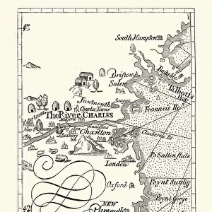
Photo Mug : Map of Massachusetts 1877


![]()
Home Decor from Fine Art Storehouse
Map of Massachusetts 1877
Warrens Common School Geography 1877
Unleash your creativity and transform your space into a visual masterpiece!
THEPALMER
Media ID 14824583
© This content is subject to copyright
Boston Maine Massachusetts Plymouth Nantucket
Large Photo Mug (15 oz)
Bring a piece of Massachusetts history to your morning routine with our Media Storehouse Photo Mug featuring the stunning 1877 Map of Massachusetts by THEPALMER from Fine Art Storehouse. This vintage geography map, originally published in Warren's Common School Atlas, adds a unique and educational touch to your daily coffee or tea. Each mug is expertly printed with high-quality, fade-resistant technology to ensure your map design remains vibrant and clear. Perfect for history enthusiasts, Massachusetts natives, or anyone who appreciates the beauty of vintage maps, this mug makes a thoughtful gift or a delightful addition to your own collection. Embrace the rich history of the Bay State with every sip.
Elevate your coffee or tea experience with our premium white ceramic mug. Its wide, comfortable handle makes drinking easy, and you can rely on it to be both microwave and dishwasher safe. Sold in single units, preview may show both sides of the same mug so you can see how the picture wraps around.
Elevate your coffee or tea experience with our premium white ceramic mug. Its wide, comfortable handle makes drinking easy, and you can rely on it to be both microwave and dishwasher safe. Sold in single units, preview may show both sides of the same mug so you can see how the picture wraps around.
These are individually made so all sizes are approximate
FEATURES IN THESE COLLECTIONS
> Fine Art Storehouse
> Map
> Historical Maps
> Fine Art Storehouse
> Map
> USA Maps
> Europe
> France
> Canton
> Maine
> Maps and Charts
> Related Images
> North America
> United States of America
> Maine
> Related Images
> North America
> United States of America
> Maps
> North America
> United States of America
> Massachusetts
> Boston
> North America
> United States of America
> Massachusetts
> Related Images
EDITORS COMMENTS
This print titled "Map of Massachusetts 1877" takes us on a journey back in time to the late 19th century. The map, sourced from Warrens Common School Geography published in 1877, offers a fascinating glimpse into the geographical landscape of Massachusetts during that era. The intricate details and vibrant colors bring this historical piece to life, showcasing not only the state itself but also its surrounding areas such as Boston, Maine, Nantucket, and Plymouth. Each city is meticulously labeled with precision and accuracy, allowing viewers to immerse themselves in the rich history of these regions. "The Map of Massachusetts 1877" by THEPALMER captures more than just cartographic information; it encapsulates an entire era's essence. It serves as a reminder of how far we have come while honoring our past. This artwork invites us to reflect upon the changes that have shaped this region over time. Whether displayed in homes or educational institutions, this print sparks curiosity and encourages exploration. Its timeless appeal makes it an ideal addition for history enthusiasts or anyone seeking a visual representation of Massachusetts' heritage. With its impeccable quality and attention to detail, Fine Art Storehouse has once again delivered an exceptional piece that celebrates both artistry and historical significance through "Map of Massachusetts 1877. "
MADE IN THE USA
Safe Shipping with 30 Day Money Back Guarantee
FREE PERSONALISATION*
We are proud to offer a range of customisation features including Personalised Captions, Color Filters and Picture Zoom Tools
SECURE PAYMENTS
We happily accept a wide range of payment options so you can pay for the things you need in the way that is most convenient for you
* Options may vary by product and licensing agreement. Zoomed Pictures can be adjusted in the Cart.