Photographic Print > North America > United States of America > Massachusetts > Boston
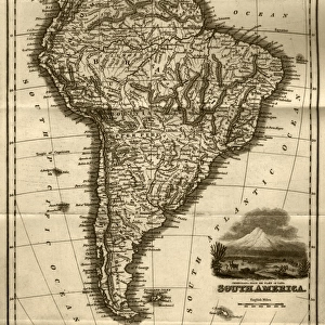
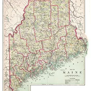
Photographic Print : Map of Massachusetts 1877


![]()
Photo Prints from Fine Art Storehouse
Map of Massachusetts 1877
Warrens Common School Geography 1877
Unleash your creativity and transform your space into a visual masterpiece!
THEPALMER
Media ID 14824583
© This content is subject to copyright
Boston Maine Massachusetts Plymouth Nantucket
11"x8.5" Photo Print
Step back in time with our exquisite 'Map of Massachusetts 1877' print from THEPALMER at Media Storehouse. This stunning piece, originally from Warren's Common School Geography of 1877, offers a captivating glimpse into the historical cartography of Massachusetts over a century ago. Meticulously preserved, each print showcases intricate details and vibrant colors, making it an essential addition to any home or office space. Transport yourself to the past and embrace the beauty of history with our Fine Art Storehouse collection.
Photo prints are produced on Kodak professional photo paper resulting in timeless and breath-taking prints which are also ideal for framing. The colors produced are rich and vivid, with accurate blacks and pristine whites, resulting in prints that are truly timeless and magnificent. Whether you're looking to display your prints in your home, office, or gallery, our range of photographic prints are sure to impress. Dimensions refers to the size of the paper in inches.
Our Photo Prints are in a large range of sizes and are printed on Archival Quality Paper for excellent colour reproduction and longevity. They are ideal for framing (our Framed Prints use these) at a reasonable cost. Alternatives include cheaper Poster Prints and higher quality Fine Art Paper, the choice of which is largely dependant on your budget.
Estimated Image Size (if not cropped) is 27.9cm x 17cm (11" x 6.7")
Estimated Product Size is 27.9cm x 21.6cm (11" x 8.5")
These are individually made so all sizes are approximate
Artwork printed orientated as per the preview above, with landscape (horizontal) orientation to match the source image.
FEATURES IN THESE COLLECTIONS
> Fine Art Storehouse
> Map
> Historical Maps
> Fine Art Storehouse
> Map
> USA Maps
> Europe
> France
> Canton
> Maine
> Maps and Charts
> Related Images
> North America
> United States of America
> Maine
> Related Images
> North America
> United States of America
> Maps
> North America
> United States of America
> Massachusetts
> Boston
> North America
> United States of America
> Massachusetts
> Related Images
EDITORS COMMENTS
This print titled "Map of Massachusetts 1877" takes us on a journey back in time to the late 19th century. The map, sourced from Warrens Common School Geography published in 1877, offers a fascinating glimpse into the geographical landscape of Massachusetts during that era. The intricate details and vibrant colors bring this historical piece to life, showcasing not only the state itself but also its surrounding areas such as Boston, Maine, Nantucket, and Plymouth. Each city is meticulously labeled with precision and accuracy, allowing viewers to immerse themselves in the rich history of these regions. "The Map of Massachusetts 1877" by THEPALMER captures more than just cartographic information; it encapsulates an entire era's essence. It serves as a reminder of how far we have come while honoring our past. This artwork invites us to reflect upon the changes that have shaped this region over time. Whether displayed in homes or educational institutions, this print sparks curiosity and encourages exploration. Its timeless appeal makes it an ideal addition for history enthusiasts or anyone seeking a visual representation of Massachusetts' heritage. With its impeccable quality and attention to detail, Fine Art Storehouse has once again delivered an exceptional piece that celebrates both artistry and historical significance through "Map of Massachusetts 1877. "
MADE IN THE USA
Safe Shipping with 30 Day Money Back Guarantee
FREE PERSONALISATION*
We are proud to offer a range of customisation features including Personalised Captions, Color Filters and Picture Zoom Tools
SECURE PAYMENTS
We happily accept a wide range of payment options so you can pay for the things you need in the way that is most convenient for you
* Options may vary by product and licensing agreement. Zoomed Pictures can be adjusted in the Cart.