Photo Mug > Arts > Artists > O > Oceanic Oceanic
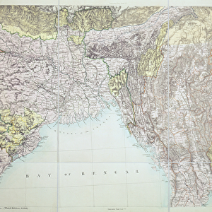
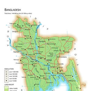
Photo Mug : Geographical map of the north-eastern section of India, early 20th century


![]()
Home Decor from Heritage Images
Geographical map of the north-eastern section of India, early 20th century
Geographical map of the north-eastern section of India, early 20th century. Pre-partition map showing the Bay of Bengal and the Ganges Delta, and what are now Bangladesh and Myanmar. Plate 57 from The Times Atlas
Heritage Images features heritage image collections
Media ID 15464834
© The Print Collector / Heritage-Images
Bay Of Bengal Burma Cartography Ganges Indian Ocean Map Making Myanmar River Ganges Hindoostan
Large Photo Mug (15 oz)
Step into the past with our Media Storehouse Photo Mug featuring a captivating geographical map of North-Eastern India from the early 20th century. This vintage map showcases the region's historical borders, including the Bay of Bengal and the Ganges Delta, as it appeared before partition. Relive history and enjoy your favorite beverage in this unique and intriguing mug, perfect for history enthusiasts and collectors. Each mug is expertly printed with high-quality images from Heritage Images to ensure a stunning and long-lasting design. Order yours today and savor the past with every sip!
Elevate your coffee or tea experience with our premium white ceramic mug. Its wide, comfortable handle makes drinking easy, and you can rely on it to be both microwave and dishwasher safe. Sold in single units, preview may show both sides of the same mug so you can see how the picture wraps around.
Elevate your coffee or tea experience with our premium white ceramic mug. Its wide, comfortable handle makes drinking easy, and you can rely on it to be both microwave and dishwasher safe. Sold in single units, preview may show both sides of the same mug so you can see how the picture wraps around.
These are individually made so all sizes are approximate
FEATURES IN THESE COLLECTIONS
> Arts
> Artists
> O
> Oceanic Oceanic
> Asia
> Bangladesh
> Maps
> Asia
> Bangladesh
> Related Images
> Asia
> India
> Related Images
> Asia
> Myanmar
> Related Images
> Maps and Charts
> Early Maps
> Maps and Charts
> India
> Maps and Charts
> Related Images
EDITORS COMMENTS
This print showcases a geographical map of the north-eastern section of India, dating back to the early 20th century. The pre-partition map offers a glimpse into the region's rich history and highlights significant landmarks such as the Bay of Bengal and the Ganges Delta. Stretching across what is now Bangladesh and Myanmar, this meticulously crafted cartographic masterpiece provides an invaluable insight into the past. Plate 57 from The Times Atlas, this vibrant print captures attention with its vivid colors and intricate details. It serves as a testament to the artistry involved in map making during that era. Every contour, river, and geographical feature has been carefully depicted, allowing viewers to immerse themselves in Hindoostan's enchanting landscapes. As we gaze upon this remarkable piece of history captured by The Print Collector, it transports us back in time when India was still under British rule. This snapshot reminds us of how borders have shifted over time while emphasizing our shared cultural heritage. While appreciating this photograph for its historical significance and artistic value, let us not forget that commercial use is prohibited without proper authorization from Heritage Images. Nevertheless, we can all marvel at this extraordinary image that encapsulates both beauty and knowledge within its frame.
MADE IN THE USA
Safe Shipping with 30 Day Money Back Guarantee
FREE PERSONALISATION*
We are proud to offer a range of customisation features including Personalised Captions, Color Filters and Picture Zoom Tools
SECURE PAYMENTS
We happily accept a wide range of payment options so you can pay for the things you need in the way that is most convenient for you
* Options may vary by product and licensing agreement. Zoomed Pictures can be adjusted in the Cart.