Photo Mug > Arts > Watercolor paintings > Fantasy-themed watercolor paintings > Mystical creatures and nature in
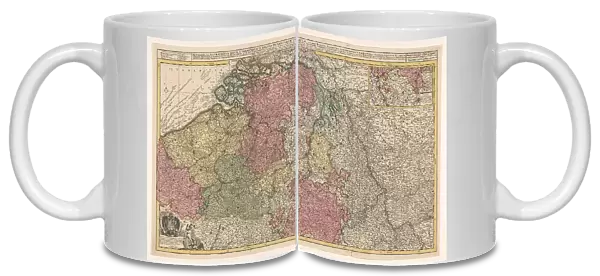
Photo Mug : Map of the southern (Austrian) Netherlands, 1719. Creator: Joachim Ottens
![]()

Home Decor from Heritage Images
Map of the southern (Austrian) Netherlands, 1719. Creator: Joachim Ottens
Map of the southern (Austrian) Netherlands, 1719. Novissima et accuratissima decem Austriacarum in Belgio provinciarum tabula, ut sunt ducatus Brabantiae, Luxembergensis, Limburgensis, et Geldriae, comitatus Flandriae'. Inset top right: part of the Duchy of Luxembourg; scale in German, Spanish and English-French miles. Bottom left: dedication to Emperor Charles VI with his coat of arms and a putto fighting a harpy
Heritage Images features heritage image collections
Media ID 36338144
© Heritage Art/Heritage Images
Amorini Belgium Europe Blazon Brabant Cherubim Club Clubbing Coastline Coat Of Arms Flanders Belgium Europe Gelderland Harpy Heraldic Heraldry Island Islands Latin Luxembourg Mythical Beasts Mythical Creatures Mythological Creature North Sea Shield Of Arms Angelic Cherubs Mythical Beast Mythical Creature Putti Watercolour Paint
Large Photo Mug (15 oz)
Add a touch of history to your daily routine with our Media Storehouse Photo Mug featuring a captivating map of the Southern Netherlands, 1719. This intricately detailed map, created by Joachim Ottens, showcases the provinces of Brabant, Limburg, Luxembourg, and Gelderland within the Austrian territories. Each sip from this high-quality mug brings you closer to the past, making it an excellent gift for history enthusiasts or anyone who appreciates the beauty of vintage cartography. Embrace the rich heritage of the past with our Photo Mug.
Elevate your coffee or tea experience with our premium white ceramic mug. Its wide, comfortable handle makes drinking easy, and you can rely on it to be both microwave and dishwasher safe. Sold in single units, preview may show both sides of the same mug so you can see how the picture wraps around.
Elevate your coffee or tea experience with our premium white ceramic mug. Its wide, comfortable handle makes drinking easy, and you can rely on it to be both microwave and dishwasher safe. Sold in single units, preview may show both sides of the same mug so you can see how the picture wraps around.
These are individually made so all sizes are approximate
FEATURES IN THESE COLLECTIONS
> Arts
> Watercolor paintings
> Fantasy-themed watercolor paintings
> Mystical creatures and nature in
> Europe
> Austria
> Related Images
> Europe
> Belgium
> Related Images
EDITORS COMMENTS
"This exquisite map print, created by Joachim Ottens in 1719, showcases the southern Netherlands, also known as the Austrian Netherlands, with remarkable detail and accuracy. The map includes the duchies of Brabant, Luxembourg, Limburg, and Gelderland, as well as the county of Flanders. An inset in the top right corner focuses on a part of the Duchy of Luxembourg, while the scale is provided in German, Spanish, and English-French miles at the bottom left. The map is richly decorated with heraldic elements, including the coat of arms of Emperor Charles VI, who ruled the Austrian Netherlands at the time, and a putto engaging in a fierce battle with a harpy. The harpy, a mythological creature with the body of a woman and the head and wings of a bird, represents the ancient mythological belief in the protection of the empire. The map is a stunning example of 18th-century cartography and the art of engraving. The vibrant colors and intricate details evoke a sense of wonder and curiosity about the geography and history of the region. The map also serves as a testament to the rich cultural heritage of Europe, with its blend of Latin, Dutch, and French influences. The map was produced during a time of war and political turmoil in Europe, making the peaceful and meticulously detailed representation of the southern Netherlands all the more remarkable. This map is a valuable addition to any collection of European history, geography, or art, and a beautiful reminder of the intricacies and complexities of the past." This description is intended for informational and educational purposes only and is not intended for commercial use. The map is part of the collection of the Rijksmuseum in Amsterdam, the Netherlands.
MADE IN THE USA
Safe Shipping with 30 Day Money Back Guarantee
FREE PERSONALISATION*
We are proud to offer a range of customisation features including Personalised Captions, Color Filters and Picture Zoom Tools
SECURE PAYMENTS
We happily accept a wide range of payment options so you can pay for the things you need in the way that is most convenient for you
* Options may vary by product and licensing agreement. Zoomed Pictures can be adjusted in the Cart.

