Photo Mug > Europe > United Kingdom > England > Maps
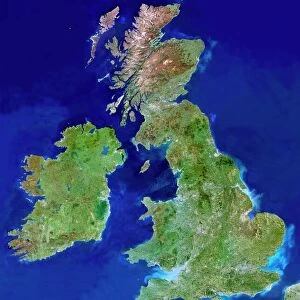
Photo Mug : Relief map of the United Kingdom and Eire


![]()
Home Decor from Science Photo Library
Relief map of the United Kingdom and Eire
Relief map of the United Kingdom and Eire, lit from the east
Science Photo Library features Science and Medical images including photos and illustrations
Media ID 6349171
© JULIAN BAUM/SCIENCE PHOTO LIBRARY
British Isles Earth Science From Space Great Ireland Relief Relief Map Sciences
Large Photo Mug (15 oz)
Introducing the Media Storehouse Photo Mug, a unique and thoughtful gift that lets you take your favorite maps with you wherever you go. This beautifully designed mug features a stunning relief map of the United Kingdom and Eire, lit from the east, captured by the expert photographers at Science Photo Library. The intricate detail of the terrain comes to life as you sip your favorite beverage, making each sip an enjoyable journey through the landscape. The high-quality ceramic material ensures a comfortable grip and a durable, long-lasting design. Give the gift of geography and history with the Media Storehouse Photo Mug.
Elevate your coffee or tea experience with our premium white ceramic mug. Its wide, comfortable handle makes drinking easy, and you can rely on it to be both microwave and dishwasher safe. Sold in single units, preview may show both sides of the same mug so you can see how the picture wraps around.
Elevate your coffee or tea experience with our premium white ceramic mug. Its wide, comfortable handle makes drinking easy, and you can rely on it to be both microwave and dishwasher safe. Sold in single units, preview may show both sides of the same mug so you can see how the picture wraps around.
These are individually made so all sizes are approximate
FEATURES IN THESE COLLECTIONS
> Europe
> Republic of Ireland
> Maps
> Europe
> United Kingdom
> England
> Maps
> Europe
> United Kingdom
> Maps
> Europe
> United Kingdom
> Related Images
> Maps and Charts
> Related Images
EDITORS COMMENTS
This print showcases a stunning relief map of the United Kingdom and Eire, beautifully illuminated from the east. The intricate details and textures of this topographic representation are brought to life, allowing viewers to immerse themselves in the diverse landscapes that make up these British Isles. From the rugged mountains of Scotland to the rolling hills of England and Wales, every contour is meticulously depicted on this map. It provides a unique perspective on the geographical features that shape this region, offering an opportunity to appreciate its natural beauty from a different vantage point. The lighting choice for this photograph adds depth and dimension to the relief map, casting shadows that emphasize elevations and depressions across the landmasses. This technique enhances our understanding of how geography influences climate patterns, river systems, and even human settlements within these territories. As we gaze upon this image captured by Science Photo Library's talented photographers, we are reminded of Earth's incredible diversity and complexity. This visual representation serves as a valuable educational tool for students studying earth sciences or anyone with an interest in geography or cartography. Whether displayed in classrooms or homes alike, this mesmerizing relief map invites us to explore Britain and Ireland through a new lens – one that encourages appreciation for both their physical characteristics and cultural heritage.
MADE IN THE USA
Safe Shipping with 30 Day Money Back Guarantee
FREE PERSONALISATION*
We are proud to offer a range of customisation features including Personalised Captions, Color Filters and Picture Zoom Tools
SECURE PAYMENTS
We happily accept a wide range of payment options so you can pay for the things you need in the way that is most convenient for you
* Options may vary by product and licensing agreement. Zoomed Pictures can be adjusted in the Cart.