Photographic Print > Europe > Belgium > Maps
Photographic Print : Map of the Coast of Flanders, Normandy and England, 1580-81 (engraving)
")

![]()
Photo Prints from Fine Art Finder
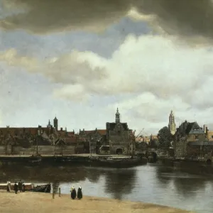
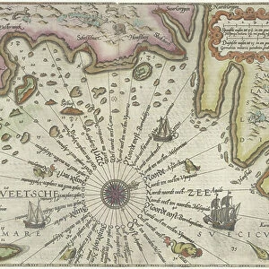
Map of the Coast of Flanders, Normandy and England, 1580-81 (engraving)
7415458 Map of the Coast of Flanders, Normandy and England, 1580-81 (engraving) by Doetecum, Joannes van (1530-1605); 32 -- 51.2 cm; Rijksmuseum, Amsterdam, The Netherlands; (add.info.: by Joannes van Doetechum (I))
Media ID 32181892
© Bridgeman Images
Beligium Blazon British Channel Coast Line Coat Of Arm Coat Or Arms Compass Card Compass Rose Compass Star Detail Artwork English Channel Flanders Heraldic Heraldic Symbols North Sea Sail Boat Sail Boats Sailboats Sailing Ship Sailing Vessel Ships Sail Unpopulated Wind Rose Belgians Belgium Belgian C16h Geographer Heraldry Seawater Without Anyone
11"x8.5" Photo Print
Discover the historical depth of this exquisite Map of the Coast of Flanders, Normandy and England, dating back to 1580-81. This intricately detailed engraving, created by the renowned artist Joannes van Doetecum, offers a fascinating glimpse into the geography and maritime knowledge of the time. Part of the Media Storehouse collection from Bridgeman Images, this fine art print brings history to life, making it an essential addition to any home or office. Explore the rich details and intricacies of this historical masterpiece, now available as a high-quality print from Fine Art Finder.
Photo prints are produced on Kodak professional photo paper resulting in timeless and breath-taking prints which are also ideal for framing. The colors produced are rich and vivid, with accurate blacks and pristine whites, resulting in prints that are truly timeless and magnificent. Whether you're looking to display your prints in your home, office, or gallery, our range of photographic prints are sure to impress. Dimensions refers to the size of the paper in inches.
Our Photo Prints are in a large range of sizes and are printed on Archival Quality Paper for excellent colour reproduction and longevity. They are ideal for framing (our Framed Prints use these) at a reasonable cost. Alternatives include cheaper Poster Prints and higher quality Fine Art Paper, the choice of which is largely dependant on your budget.
Estimated Image Size (if not cropped) is 27.9cm x 17.6cm (11" x 6.9")
Estimated Product Size is 27.9cm x 21.6cm (11" x 8.5")
These are individually made so all sizes are approximate
Artwork printed orientated as per the preview above, with landscape (horizontal) orientation to match the source image.
FEATURES IN THESE COLLECTIONS
> Fine Art Finder
> Artists
> Egon Schiele
> Fine Art Finder
> Artists
> Joannes van Doetecum
> Europe
> Belgium
> Paintings
> Europe
> Belgium
> Related Images
> Europe
> France
> Sport
> Sailing
> Europe
> Netherlands
> Amsterdam
> Europe
> Netherlands
> Maps
> Europe
> Netherlands
> Paintings
EDITORS COMMENTS
This print showcases the "Map of the Coast of Flanders, Normandy and England" created by Joannes van Doetecum in 1580-81. Measuring 32 -- 51.2 cm, this engraving is housed at the renowned Rijksmuseum in Amsterdam, The Netherlands. The intricate details and skilled craftsmanship of this map transport viewers back to the 16th century. It offers a fascinating glimpse into the geographical landscape of Flanders, Normandy, and England during that time period. With its vibrant colors and precise cartography, it serves as both a work of art and an important historical document. The map features various heraldic symbols representing different regions along with their coat of arms. This inclusion adds a touch of elegance to the overall composition while also providing valuable insights into European geography from centuries ago. As we explore this piece further, we are reminded not only of its artistic value but also its significance as a tool for navigation and exploration during that era. It allows us to imagine sailors relying on maps like these to navigate treacherous waters or plan strategic military campaigns. Overall, this print captures a moment frozen in time—a testament to human curiosity and ingenuity in mapping out our world. Its presence within Fine Art Finder's collection ensures that future generations can continue to appreciate its beauty and historical importance for years to come.
MADE IN THE USA
Safe Shipping with 30 Day Money Back Guarantee
FREE PERSONALISATION*
We are proud to offer a range of customisation features including Personalised Captions, Color Filters and Picture Zoom Tools
SECURE PAYMENTS
We happily accept a wide range of payment options so you can pay for the things you need in the way that is most convenient for you
* Options may vary by product and licensing agreement. Zoomed Pictures can be adjusted in the Cart.