Photographic Print > Animals > Mammals > Cats (Wild) > Populator
Photographic Print : Geographic map of the Mediterranean Sea and the Black Sea showing the coasts of Europe (France, Spain, Italy and Africa (Tunisia, Algeria, Egypt). The sea is populated with monsters and caravels
. The sea is populated with monsters and caravels")

![]()
Photo Prints from Fine Art Finder
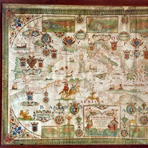
Geographic map of the Mediterranean Sea and the Black Sea showing the coasts of Europe (France, Spain, Italy and Africa (Tunisia, Algeria, Egypt). The sea is populated with monsters and caravels
JLJ4592326 Geographic map of the Mediterranean Sea and the Black Sea showing the coasts of Europe (France, Spain, Italy and Africa (Tunisia, Algeria, Egypt). The sea is populated with monsters and caravels, while on the land are visible all kinds of animals and inhabitants of the regions). Each country is marked by its coat of arms. Map of Francois Ollive, 1646. Paris, Musee de la Marine by Ollive, Francois (active 1646-1662); Musee de la Marine, Paris, France; (add.info.: Geographic map of the Mediterranean Sea and the Black Sea showing the coasts of Europe (France, Spain, Italy and Africa (Tunisia, Algeria, Egypt). The sea is populated with monsters and caravels, while on the land are visible all kinds of animals and inhabitants of the regions). Each country is marked by its coat of arms. Map of Francois Ollive, 1646. Paris, Musee de la Marine); Photo © Photo Josse
Media ID 25184364
© Josse / Bridgeman Images
Blazon Coat Of Arm Maghrebin Maghrebine Mediterranean Sea Central Africa Geographical Map Maghreb
10"x8" Photo Print
Discover the mystical allure of the Mediterranean and Black Seas with our stunning photographic print from Media Storehouse. This exquisite piece, titled "Mediterranean and Black Seas: A Sea of Legends" by renowned photographer Josse from Fine Art Finder, brings to life the rich history and culture of Europe and Africa. Featuring the coastlines of France, Spain, Italy, Tunisia, Algeria, and Egypt, this geographic map is transformed into an enchanting seascape teeming with monsters and caravels. Add an element of intrigue and wonder to your home or office decor with this captivating work of art.
Photo prints are produced on Kodak professional photo paper resulting in timeless and breath-taking prints which are also ideal for framing. The colors produced are rich and vivid, with accurate blacks and pristine whites, resulting in prints that are truly timeless and magnificent. Whether you're looking to display your prints in your home, office, or gallery, our range of photographic prints are sure to impress. Dimensions refers to the size of the paper in inches.
Our Photo Prints are in a large range of sizes and are printed on Archival Quality Paper for excellent colour reproduction and longevity. They are ideal for framing (our Framed Prints use these) at a reasonable cost. Alternatives include cheaper Poster Prints and higher quality Fine Art Paper, the choice of which is largely dependant on your budget.
Estimated Image Size (if not cropped) is 25.4cm x 18cm (10" x 7.1")
Estimated Product Size is 25.4cm x 20.3cm (10" x 8")
These are individually made so all sizes are approximate
Artwork printed orientated as per the preview above, with landscape (horizontal) orientation to match the source image.
FEATURES IN THESE COLLECTIONS
> Fine Art Finder
> Artists
> Francois Ollive
> Fine Art Finder
> Artists
> Guido da Vigevano da Pavia
> Africa
> Algeria
> Related Images
> Africa
> Egypt
> Related Images
> Africa
> Tunisia
> Related Images
> Animals
> Mammals
> Cats (Wild)
> Populator
> Europe
> France
> Canton
> Landes
> Europe
> France
> Paris
> Maps
EDITORS COMMENTS
This print showcases a historic geographic map of the Mediterranean Sea and the Black Sea, created by Francois Ollive in 1646. The map beautifully depicts the coasts of Europe, including France, Spain, Italy, as well as Africa with Tunisia, Algeria, and Egypt. What makes this map truly fascinating is its imaginative portrayal of the sea and land. In the vast expanse of water, we see an array of mythical monsters alongside caravels sailing through these treacherous waters. These fantastical creatures add an element of mystery to the otherwise familiar geography. On land, every region comes to life with various animals and inhabitants depicted in intricate detail. To distinguish each country on this remarkable map, their respective coat of arms is proudly displayed. This attention to detail not only adds visual interest but also provides historical context for understanding political boundaries during that era. Preserved at Musee de la Marine in Paris today, this artwork serves as a testament to Ollive's skillful cartography and his ability to blend reality with imagination. Through this photograph taken by Photo Josse from Fine Art Finder (not mentioning commercial use), we are able to appreciate both the artistry behind this ancient map and gain insight into how people perceived their world centuries ago.
MADE IN THE USA
Safe Shipping with 30 Day Money Back Guarantee
FREE PERSONALISATION*
We are proud to offer a range of customisation features including Personalised Captions, Color Filters and Picture Zoom Tools
SECURE PAYMENTS
We happily accept a wide range of payment options so you can pay for the things you need in the way that is most convenient for you
* Options may vary by product and licensing agreement. Zoomed Pictures can be adjusted in the Cart.