Photographic Print > Europe > United Kingdom > England > London > Museums > National Maritime Museum
Photographic Print : Colour map of Dominica with detailed geographical observations, c.1760 (hand coloured engraving)
")

![]()
Photo Prints from Fine Art Finder
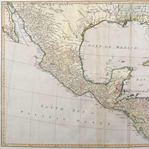
Colour map of Dominica with detailed geographical observations, c.1760 (hand coloured engraving)
7339471 Colour map of Dominica with detailed geographical observations, c.1760 (hand coloured engraving) by Jefferys, Thomas (c.1719-71); 63.5x48 cm; National Maritime Museum, London, UK; (add.info.: Creator: Thomas Jeffereys
Scale [circa 1:120, 000]. Contains an inset of Prince Rupert's Bay [circa 1:35, 000 (bar)].); © National Maritime Museum, Greenwich, London
Media ID 38519876
© © National Maritime Museum, Greenwich, London / Bridgeman Images
Caribbean Dominican Republic Isles 18e Siecle 18th Century 18th Centuries
10"x8" Photo Print
"Step back in time with our stunning Photographic Prints from the Media Storehouse range! This beautiful piece, 'Colour map of Dominica with detailed geographical observations, c.1760 (hand coloured engraving)' by Bridgeman Images from Fine Art Finder, is a breathtaking reproduction of an original hand-coloured engraving by Thomas Jefferys. Depicting the island of Dominica in vivid detail, this print showcases the cartographer's meticulous attention to geography and natural features. Perfect for history buffs and art lovers alike, this unique piece would make a fantastic addition to any room."
Photo prints are produced on Kodak professional photo paper resulting in timeless and breath-taking prints which are also ideal for framing. The colors produced are rich and vivid, with accurate blacks and pristine whites, resulting in prints that are truly timeless and magnificent. Whether you're looking to display your prints in your home, office, or gallery, our range of photographic prints are sure to impress. Dimensions refers to the size of the paper in inches.
Our Photo Prints are in a large range of sizes and are printed on Archival Quality Paper for excellent colour reproduction and longevity. They are ideal for framing (our Framed Prints use these) at a reasonable cost. Alternatives include cheaper Poster Prints and higher quality Fine Art Paper, the choice of which is largely dependant on your budget.
Estimated Product Size is 20.3cm x 25.4cm (8" x 10")
These are individually made so all sizes are approximate
Artwork printed orientated as per the preview above, with landscape (horizontal) or portrait (vertical) orientation to match the source image.
FEATURES IN THESE COLLECTIONS
> Fine Art Finder
> Artists
> Thomas Jefferys
> Arts
> Artists
> H
> Thomas Hand
> Arts
> Artists
> J
> Thomas Jefferys
> Arts
> Photorealistic artworks
> Detailed art pieces
> Masterful detailing in art
> Europe
> United Kingdom
> England
> London
> Boroughs
> Greenwich
> Europe
> United Kingdom
> England
> London
> Museums
> Greenwich Heritage Centre
> Europe
> United Kingdom
> England
> London
> Museums
> National Maritime Museum
> Europe
> United Kingdom
> England
> London
> Towns
> Greenwich
> Europe
> United Kingdom
> Heritage Sites
> Maritime Greenwich
> Europe
> United Kingdom
> Maps
> Maps and Charts
> Early Maps
EDITORS COMMENTS
This stunning hand-colored engraving from the 18th century showcases a detailed colour map of Dominica, created by Thomas Jefferys. The intricate details and geographical observations on this map provide a fascinating glimpse into the island's landscape during that time period.
The map, measuring 63.5x48 cm, is part of the collection at the National Maritime Museum in London, UK. It offers a scale of approximately 1:120,000 and includes an inset of Prince Rupert's Bay at around 1:35,000 (bar). The vibrant colors used to highlight different regions on the map bring it to life and make it visually striking.
This historical artifact not only serves as a valuable tool for understanding the geography of Dominica in the past but also reflects the artistry and skill of cartographers like Jefferys. The level of detail captured in this engraving demonstrates the precision and dedication required to create such maps before modern technology made mapping more accessible.
Overall, this colour map of Dominica is a testament to both scientific exploration and artistic expression. It provides viewers with a window into history while showcasing the beauty and complexity of cartography in centuries past.
MADE IN THE USA
Safe Shipping with 30 Day Money Back Guarantee
FREE PERSONALISATION*
We are proud to offer a range of customisation features including Personalised Captions, Color Filters and Picture Zoom Tools
SECURE PAYMENTS
We happily accept a wide range of payment options so you can pay for the things you need in the way that is most convenient for you
* Options may vary by product and licensing agreement. Zoomed Pictures can be adjusted in the Cart.