Photographic Print > Arts > Artists > L > Antoine Lafrery
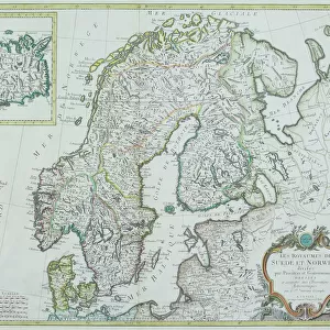
Photographic Print : Detail of A Map of the Sea (Carta marina) by Olaus Magnus (1490-1557), 1572 (engraving)
 by Olaus Magnus (1490-1557), 1572 (engraving)")

![]()
Photo Prints from Fine Art Finder
Detail of A Map of the Sea (Carta marina) by Olaus Magnus (1490-1557), 1572 (engraving)
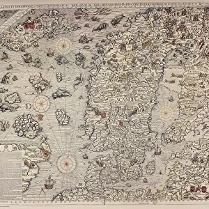
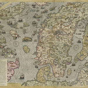
7394857 Detail of A Map of the Sea (Carta marina) by Olaus Magnus (1490-1557), 1572 (engraving) by Lafrery, Antoine (1512-77); Private Collection; (add.info.: The Carta marina of the Swedish geographer and historian Olaus Magnus (1490-1557) is one of the earliest accurate cartographic depictions of the Scandinavian peninsula. This is the second edition of this map, published by Antoine Lafréry in 1572.)
Media ID 32115198
© Bridgeman Images
Aquatic Mammal Baltics Compass Compass Card Estonia Fantastic Animal Fantastic Creature Fantastic Creatures Finland Humpback Whale Islands Isles Latvia Lithuania Marine Mammal Marine Mammals Mythical Animal Mythical Beast Mythical Creature Mythical Creatures North Sea Norway Sea Mammal Sverige Sweden Whale World Map C16h Geographer Seawater
10"x8" Photo Print
Discover the captivating detail of the ancient world with our Media Storehouse range of Photographic Prints. This exquisite image showcases a fascinating detail from Olaus Magnus's iconic map, "Carta marina," created in 1572. Engraved by Antoine Lafrery, this intricate work of art depicts the intricacies of the known world during the Renaissance era. Transport yourself back in time and add a touch of history to your space with this stunning, museum-quality print.
Photo prints are produced on Kodak professional photo paper resulting in timeless and breath-taking prints which are also ideal for framing. The colors produced are rich and vivid, with accurate blacks and pristine whites, resulting in prints that are truly timeless and magnificent. Whether you're looking to display your prints in your home, office, or gallery, our range of photographic prints are sure to impress. Dimensions refers to the size of the paper in inches.
Our Photo Prints are in a large range of sizes and are printed on Archival Quality Paper for excellent colour reproduction and longevity. They are ideal for framing (our Framed Prints use these) at a reasonable cost. Alternatives include cheaper Poster Prints and higher quality Fine Art Paper, the choice of which is largely dependant on your budget.
Estimated Product Size is 25.4cm x 20.3cm (10" x 8")
These are individually made so all sizes are approximate
Artwork printed orientated as per the preview above, with landscape (horizontal) or portrait (vertical) orientation to match the source image.
FEATURES IN THESE COLLECTIONS
> Fine Art Finder
> Artists
> Antoine Lafrery
> Animals
> Aquatic
> Cetacea
> Whale
> Animals
> Aquatic
> Related Images
> Animals
> Mammals
> Balaenopteridae
> Humpback Whale
> Animals
> Mammals
> Humpback Whale
> Animals
> Mammals
> Muridae
> Magnus
> Arts
> Artists
> L
> Antoine Lafrery
> Europe
> Estonia
> Related Images
EDITORS COMMENTS
This print showcases a mesmerizing detail of "A Map of the Sea (Carta marina)" by Olaus Magnus, an esteemed Swedish geographer and historian from the 16th century. Published in 1572 by Antoine Lafréry, this engraving is considered one of the earliest accurate cartographic depictions of the Scandinavian peninsula. The intricate artwork reveals a world teeming with mythical creatures and fantastic beasts, capturing our imagination and transporting us to a time when legends roamed the seas. Amongst these enchanting beings, we spot a majestic humpback whale gracefully gliding through the waves, reminding us of the vastness and beauty of marine life. The map itself is meticulously crafted with vibrant colors that bring it to life. It portrays various islands, including those found in Scandinavia such as Sweden and Finland. The compass card serves as both a navigational tool for seafarers and an artistic element that adds depth to this remarkable piece. As we explore this historical artifact, we are reminded not only of its significance in cartography but also its portrayal of Europe's maritime history. From Norway to Estonia, Lithuania to Latvia, this map captures the interconnectedness between landmasses and their relationship with surrounding seas. Through Bridgeman Images' lens, we are granted access to this extraordinary work that combines artistry with scientific precision—a testament to human curiosity about our world's wonders centuries ago.
MADE IN THE USA
Safe Shipping with 30 Day Money Back Guarantee
FREE PERSONALISATION*
We are proud to offer a range of customisation features including Personalised Captions, Color Filters and Picture Zoom Tools
SECURE PAYMENTS
We happily accept a wide range of payment options so you can pay for the things you need in the way that is most convenient for you
* Options may vary by product and licensing agreement. Zoomed Pictures can be adjusted in the Cart.