Photographic Print > Arts > Photorealistic artworks > Detailed art pieces > Masterful detailing in art
Photographic Print : Asia Map - illustration


![]()
Photo Prints from Fine Art Storehouse
Asia Map - illustration
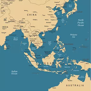
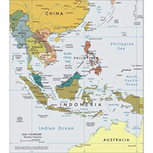
Colored Map of Asia with Country Names and Capital Cities The url of the reference to map is: http:/lib.utexas.edu/maps/world_maps/time_zones_ref_2011.pdf. In addition - some city locations were taken from: http:/lib.utexas.edu/maps/world_maps/txu-oclc-264266980-world_pol_2008-2.jpg. The illustration completed August 14, 2015 and created in Corel Draw 1 layer of data used for the detailed outline of the land
Unleash your creativity and transform your space into a visual masterpiece!
Media ID 14777521
10"x8" Photo Print
Discover the beauty and diversity of Asia with our stunning Fine Art Storehouse Photographic Prints. This captivating image showcases a vibrant and intricately detailed map of Asia, featuring clear country names and capital cities. Each print is meticulously crafted to bring out the rich colors and intricacies of this illustration, transporting you on an adventure across the continent. Perfect for home or office decor, this unique and thoughtful piece is sure to inspire wanderlust and ignite the imagination. Reference map:
Photo prints are produced on Kodak professional photo paper resulting in timeless and breath-taking prints which are also ideal for framing. The colors produced are rich and vivid, with accurate blacks and pristine whites, resulting in prints that are truly timeless and magnificent. Whether you're looking to display your prints in your home, office, or gallery, our range of photographic prints are sure to impress. Dimensions refers to the size of the paper in inches.
Our Photo Prints are in a large range of sizes and are printed on Archival Quality Paper for excellent colour reproduction and longevity. They are ideal for framing (our Framed Prints use these) at a reasonable cost. Alternatives include cheaper Poster Prints and higher quality Fine Art Paper, the choice of which is largely dependant on your budget.
Estimated Product Size is 25.4cm x 20.3cm (10" x 8")
These are individually made so all sizes are approximate
Artwork printed orientated as per the preview above, with landscape (horizontal) or portrait (vertical) orientation to match the source image.
FEATURES IN THESE COLLECTIONS
> Fine Art Storehouse
> Map
> Map Illustrations
> Arts
> Photorealistic artworks
> Detailed art pieces
> Masterful detailing in art
> Asia
> Related Images
> Europe
> France
> Canton
> Landes
> Maps and Charts
> Related Images
EDITORS COMMENTS
This print showcases a beautifully colored map of Asia, complete with country names and capital cities. The intricate details of this illustration were meticulously crafted using Corel Draw software, ensuring accuracy and precision. Created on August 14,2015, this artwork represents a labor of love that celebrates the diverse geography and cultural richness of the Asian continent. The reference for this map can be found at http:/lib. utexas. edu/maps/world_maps/time_zones_ref_2011. pdf, while additional city locations were sourced from http:/lib. utexas. edu/maps/world_maps/txu-oclc-264266980-world_pol_2008-2. jpg. These reliable sources contribute to the authenticity and reliability of the information depicted in this stunning piece. As you explore this print, allow yourself to immerse in the vastness of Asia's landscapes - from snow-capped mountains to lush rainforests; bustling metropolises to serene rural areas. Each country is clearly labeled alongside its respective capital city, providing an educational experience as well. Whether you are an avid traveler or simply fascinated by world cultures, this print serves as both an aesthetic delight and a valuable resource. Hang it proudly on your wall or gift it to someone who shares your passion for exploration. Let this vibrant depiction ignite your curiosity about Asia's wonders and inspire dreams of future adventures across its diverse nations.
MADE IN THE USA
Safe Shipping with 30 Day Money Back Guarantee
FREE PERSONALISATION*
We are proud to offer a range of customisation features including Personalised Captions, Color Filters and Picture Zoom Tools
SECURE PAYMENTS
We happily accept a wide range of payment options so you can pay for the things you need in the way that is most convenient for you
* Options may vary by product and licensing agreement. Zoomed Pictures can be adjusted in the Cart.