Premium Framed Print > Arts > Photorealistic artworks > Detailed art pieces > Masterful detailing in art
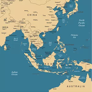
Premium Framed Print : Asia Map - illustration


![]()
Framed Photos from Fine Art Storehouse
Asia Map - illustration
Colored Map of Asia with Country Names and Capital Cities The url of the reference to map is: http:/lib.utexas.edu/maps/world_maps/time_zones_ref_2011.pdf. In addition - some city locations were taken from: http:/lib.utexas.edu/maps/world_maps/txu-oclc-264266980-world_pol_2008-2.jpg. The illustration completed August 14, 2015 and created in Corel Draw 1 layer of data used for the detailed outline of the land
Unleash your creativity and transform your space into a visual masterpiece!
Media ID 14777521
14"x16" Premium Frame
Contemporary style Premium Wooden Frame with 8"x10" Print. Complete with 2" White Mat and 1.25" thick MDF frame. Printed on 260 gsm premium paper. Glazed with shatter proof UV coated acrylic glass. Backing is paper covered backing with rubber bumpers. Supplied ready to hang with a pre-installed sawtooth/wire hanger. Care Instructions: Spot clean with a damp cloth. Securely packaged in a clear plastic bag and envelope in a reinforced cardboard shipper
FSC Real Wood Frame and Double Mounted with White Conservation Mountboard - Professionally Made and Ready to Hang
Estimated Image Size (if not cropped) is 25.4cm x 20.3cm (10" x 8")
Estimated Product Size is 40.6cm x 35.6cm (16" x 14")
These are individually made so all sizes are approximate
Artwork printed orientated as per the preview above, with landscape (horizontal) orientation to match the source image.
FEATURES IN THESE COLLECTIONS
> Fine Art Storehouse
> Map
> Map Illustrations
> Arts
> Photorealistic artworks
> Detailed art pieces
> Masterful detailing in art
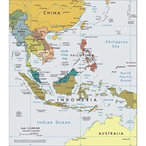
> Asia
> Related Images
> Europe
> France
> Canton
> Landes
> Maps and Charts
> Related Images
EDITORS COMMENTS
This print showcases a beautifully colored map of Asia, complete with country names and capital cities. The intricate details of this illustration were meticulously crafted using Corel Draw software, ensuring accuracy and precision. Created on August 14,2015, this artwork represents a labor of love that celebrates the diverse geography and cultural richness of the Asian continent. The reference for this map can be found at http:/lib. utexas. edu/maps/world_maps/time_zones_ref_2011. pdf, while additional city locations were sourced from http:/lib. utexas. edu/maps/world_maps/txu-oclc-264266980-world_pol_2008-2. jpg. These reliable sources contribute to the authenticity and reliability of the information depicted in this stunning piece. As you explore this print, allow yourself to immerse in the vastness of Asia's landscapes - from snow-capped mountains to lush rainforests; bustling metropolises to serene rural areas. Each country is clearly labeled alongside its respective capital city, providing an educational experience as well. Whether you are an avid traveler or simply fascinated by world cultures, this print serves as both an aesthetic delight and a valuable resource. Hang it proudly on your wall or gift it to someone who shares your passion for exploration. Let this vibrant depiction ignite your curiosity about Asia's wonders and inspire dreams of future adventures across its diverse nations.
MADE IN THE USA
Safe Shipping with 30 Day Money Back Guarantee
FREE PERSONALISATION*
We are proud to offer a range of customisation features including Personalised Captions, Color Filters and Picture Zoom Tools
SECURE PAYMENTS
We happily accept a wide range of payment options so you can pay for the things you need in the way that is most convenient for you
* Options may vary by product and licensing agreement. Zoomed Pictures can be adjusted in the Cart.