Photographic Print > Europe > France > Canton > Nord
Photographic Print : Carte geologique; Afrique du nord, 1914. Creator: Unknown

![]()
Photo Prints from Heritage Images
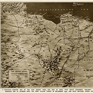
Carte geologique; Afrique du nord, 1914. Creator: Unknown
Carte geologique; Afrique du nord, 1914. From "Grande Geographie Bong Illustree", 1914
Heritage Images features heritage image collections
Media ID 36294647
© The Print Collector/Heritage Images
Algeria Atlantic Ocean Atlas Mountains Cartography Desert Geological Geological Map Geology Map Making Mapmaking Mediterranean Sea Morocco Mountain Range North Africa North African Ocean Sahara Sahara Desert Africa Tunisia
12"x8" Photo Print
Discover the intriguing fusion of geology and cartography in this rare and captivating vintage print from Media Storehouse's extensive collection. Titled "Carte geologique; Afrique du nord," this 1914 piece is an unknown creation from the esteemed publication "Grande Geographie Bong Illustree." The image showcases the geological formations of North Africa, offering a unique perspective on the region's geological history. Add an air of mystery and intrigue to your space with this beautiful, one-of-a-kind, and unknown provenance print. Order now and bring a piece of history into your home or office.
Photo prints are produced on Kodak professional photo paper resulting in timeless and breath-taking prints which are also ideal for framing. The colors produced are rich and vivid, with accurate blacks and pristine whites, resulting in prints that are truly timeless and magnificent. Whether you're looking to display your prints in your home, office, or gallery, our range of photographic prints are sure to impress. Dimensions refers to the size of the paper in inches.
Our Photo Prints are in a large range of sizes and are printed on Archival Quality Paper for excellent colour reproduction and longevity. They are ideal for framing (our Framed Prints use these) at a reasonable cost. Alternatives include cheaper Poster Prints and higher quality Fine Art Paper, the choice of which is largely dependant on your budget.
Estimated Image Size (if not cropped) is 30.4cm x 17.8cm (12" x 7")
Estimated Product Size is 30.5cm x 20.3cm (12" x 8")
These are individually made so all sizes are approximate
Artwork printed orientated as per the preview above, with landscape (horizontal) orientation to match the source image.
FEATURES IN THESE COLLECTIONS
> Africa
> Algeria
> Related Images
> Africa
> Morocco
> Related Images
> Africa
> Tunisia
> Related Images
> Animals
> Mammals
> Muridae
> Desert Mouse
> Europe
> France
> Canton
> Nord
EDITORS COMMENTS
This black and white geological map, titled "Carte geologique; Afrique du Nord," was published in the renowned French geographical magazine "Grande Geographie Illustree" in 1914. The creator of this masterpiece remains unknown, adding to its intriguing allure. The map provides a detailed representation of the geological features of North Africa during the early 20th century. The map encompasses the North African region, stretching from the Atlantic Ocean in the west to the Mediterranean Sea in the north, and extending eastward to cover parts of present-day Algeria, Tunisia, Libya, Egypt, and Morocco. The Sahara Desert, a vast expanse of arid land, dominates the southern part of the map. The map is adorned with various geological symbols, indicating different rock formations and mineral deposits. Notable geographical features, such as the Atlas Mountains, are clearly marked, providing valuable information for both scientific research and exploration. The coastline is meticulously detailed, highlighting the bays, peninsulas, and capes that characterize the North African coast. The map's creation during the 1910s, a time when European powers were actively expanding their influence in Africa, underscores the importance of geographical knowledge in shaping global politics. France, in particular, held significant territorial claims in North Africa, making this map a testament to the French interest and involvement in the region. Despite its age, the "Carte geologique; Afrique du Nord" remains a fascinating piece of cartographic history, showcasing the meticulous detail and scientific accuracy that characterized mapmaking during the early 20th century. Its intricate engravings and valuable geological information continue to captivate scholars, historians, and enthusiasts of cartography and geology alike.
MADE IN THE USA
Safe Shipping with 30 Day Money Back Guarantee
FREE PERSONALISATION*
We are proud to offer a range of customisation features including Personalised Captions, Color Filters and Picture Zoom Tools
SECURE PAYMENTS
We happily accept a wide range of payment options so you can pay for the things you need in the way that is most convenient for you
* Options may vary by product and licensing agreement. Zoomed Pictures can be adjusted in the Cart.