Photographic Print > Europe > United Kingdom > England > London > Towns > West Green
Photographic Print : The Destruction of Roman Britain, 1926. Creators: Unknown, Emery Walker Ltd


![]()
Photo Prints from Heritage Images
The Destruction of Roman Britain, 1926. Creators: Unknown, Emery Walker Ltd
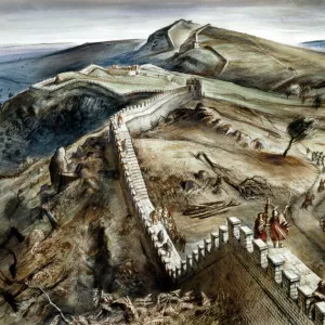
The Destruction of Roman Britain, 1926. Map of Britain showing invasions towards the end of the Roman period (43 to 410 AD). The arrows indicate the general direction of the attacks on Roman Britain; not particular expeditions, which are conjectural. Attacks from East to West are Anglo-Saxon, the others Celtic. From " History of England", by George Macaulay Trevelyan. [Longmans, Green and Co. Ltd, London, 1926]
Heritage Images features heritage image collections
Media ID 19044908
© The Print Collector/Heritage Images
Anglo Saxon Attack Boutall Cartography Celtic Celts Coastline Cockerell Emery Emery Walker Limited Emery Walker Ltd Gaul Great Britain Green And Co Hadrians Wall History Of England Invasion Ireland Longman Longman And Co Longmans Map Making North Sea Occupied Territory Roberts And Green Roman Britain Roman Empire Saxon Saxons Trevelyan Wales Walker Walker And Walker And Boutall Walker And Cockerell Picts
11"x8.5" Photo Print
Step back in time with our captivating selection from the Media Storehouse range of Photographic Prints. This vintage image, titled "The Destruction of Roman Britain, 1926," is an intriguing map depicting the invasions towards the end of the Roman period in Britain (43 to 410 AD). Created by the skilled artisans at Emery Walker Ltd and sourced from Heritage Images, this print offers a fascinating glimpse into history. Add this unique piece to your collection and let the story of Roman Britain unfold in your home or office.
Photo prints are produced on Kodak professional photo paper resulting in timeless and breath-taking prints which are also ideal for framing. The colors produced are rich and vivid, with accurate blacks and pristine whites, resulting in prints that are truly timeless and magnificent. Whether you're looking to display your prints in your home, office, or gallery, our range of photographic prints are sure to impress. Dimensions refers to the size of the paper in inches.
Our Photo Prints are in a large range of sizes and are printed on Archival Quality Paper for excellent colour reproduction and longevity. They are ideal for framing (our Framed Prints use these) at a reasonable cost. Alternatives include cheaper Poster Prints and higher quality Fine Art Paper, the choice of which is largely dependant on your budget.
Estimated Image Size (if not cropped) is 27.9cm x 18.1cm (11" x 7.1")
Estimated Product Size is 27.9cm x 21.6cm (11" x 8.5")
These are individually made so all sizes are approximate
Artwork printed orientated as per the preview above, with landscape (horizontal) orientation to match the source image.
FEATURES IN THESE COLLECTIONS
> Arts
> Artists
> R
> Roman Roman
> Arts
> Artists
> W
> Robert Walker
> Arts
> Literature
> Europe
> Italy
> Lazio
> Rome
> Europe
> Republic of Ireland
> Maps
> Europe
> United Kingdom
> England
> London
> Towns
> North End
> Europe
> United Kingdom
> England
> London
> Towns
> West Green
> Europe
> United Kingdom
> England
> Maps
The Destruction of Roman Britain, 1926
EDITORS COMMENTS
is a captivating print that offers a glimpse into the historical events that unfolded during the Roman period in Britain. Created by an unknown artist and published by Emery Walker Ltd, this map showcases the invasions that occurred towards the end of Roman rule from 43 to 410 AD. The map features arrows indicating the general direction of attacks on Roman Britain, distinguishing between Anglo-Saxon and Celtic assaults. It should be noted that these expeditions are speculative rather than based on concrete evidence. The visual representation provides valuable insights into how different regions were impacted by these invasions. Taken from "History of England" written by George Macaulay Trevelyan and published by Longmans, Green and Co. Ltd in London in 1926, this artwork combines history with cartography to create a comprehensive understanding of ancient British geography. The print captures not only the geographical features but also highlights significant landmarks such as Hadrian's Wall, which served as a defense against invaders from the north. With its vibrant colors and meticulous detailing, this piece serves as both an educational tool and a work of art. This photograph print transports us back to a time when great empires clashed on British soil. It reminds us of our rich heritage while encouraging further exploration into our past.
MADE IN THE USA
Safe Shipping with 30 Day Money Back Guarantee
FREE PERSONALISATION*
We are proud to offer a range of customisation features including Personalised Captions, Color Filters and Picture Zoom Tools
SECURE PAYMENTS
We happily accept a wide range of payment options so you can pay for the things you need in the way that is most convenient for you
* Options may vary by product and licensing agreement. Zoomed Pictures can be adjusted in the Cart.