Photographic Print > Europe > United Kingdom > England > Herefordshire > Ledbury > Charles II
Photographic Print : Map of Antietam, Sharpsburg and Vicinity, Maryland, 1862 (1862-1867). Artist: Rae Smith
. Artist: Rae Smith")
![]()
Photo Prints from Heritage Images
Map of Antietam, Sharpsburg and Vicinity, Maryland, 1862 (1862-1867). Artist: Rae Smith
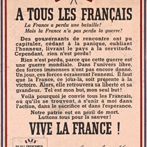
Map of Antietam, Sharpsburg and Vicinity, Maryland, 1862 (1862-1867) The Battle of Antietam, fought on 17 September 1862, was the first battle of the American Civil War to be fought on Union (northern) soil. It was the bloodiest single day battle in American history, with nearly 23, 000 casualties. An engraving from volume II of The War with the South : a History of the Late Rebellion, by Robert Tomes, Benjamin G Smith, New York, Virtue & Yorston, 3 Volumes, 1862-1867
Heritage Images features heritage image collections
Media ID 14910676
© The Print Collector / Heritage-Images
Battle Of Antietam Cartography Map Making Smith Strategy American Civil War Battlefield Print Collector3
11"x8.5" Photo Print
Step back in time with our exclusive Media Storehouse Photographic Print of the "Map of Antietam, Sharpsburg and Vicinity, Maryland, 1862 (1862-1867)" by Rae Smith and Charles Sholl. This historic map, depicting the Battle of Antietam, one of the first major engagements of the American Civil War, is a captivating addition to any home or office. Created by renowned artist Rae Smith and published between 1862 and 1867, this map offers a unique glimpse into the past. Experience the rich history of this significant battle and bring a piece of the past into your present with our high-quality photographic print.
Photo prints are produced on Kodak professional photo paper resulting in timeless and breath-taking prints which are also ideal for framing. The colors produced are rich and vivid, with accurate blacks and pristine whites, resulting in prints that are truly timeless and magnificent. Whether you're looking to display your prints in your home, office, or gallery, our range of photographic prints are sure to impress. Dimensions refers to the size of the paper in inches.
Our Photo Prints are in a large range of sizes and are printed on Archival Quality Paper for excellent colour reproduction and longevity. They are ideal for framing (our Framed Prints use these) at a reasonable cost. Alternatives include cheaper Poster Prints and higher quality Fine Art Paper, the choice of which is largely dependant on your budget.
Estimated Image Size (if not cropped) is 19.1cm x 27.9cm (7.5" x 11")
Estimated Product Size is 21.6cm x 27.9cm (8.5" x 11")
These are individually made so all sizes are approximate
Artwork printed orientated as per the preview above, with portrait (vertical) orientation to match the source image.
FEATURES IN THESE COLLECTIONS
> Arts
> Artists
> Related Images
> Arts
> Artists
> S
> Charles Smith
> Arts
> Artists
> S
> Robert Smith
> Europe
> United Kingdom
> England
> Herefordshire
> Ledbury
> Charles II
> Historic
> Battles
> Related Images
> Maps and Charts
> Related Images
> North America
> United States of America
> Maps
> North America
> United States of America
> Maryland
> Related Images
> North America
> United States of America
> New York
> New York
> Maps
EDITORS COMMENTS
This print showcases a historic map titled "Map of Antietam, Sharpsburg and Vicinity, Maryland, 1862 (1862-1867)" created by the talented artist Rae Smith. The map depicts the location and strategic layout of the Battle of Antietam, which took place on September 17th, 1862. This battle holds significant importance as it was the first major conflict of the American Civil War to occur on Union soil. The image captures the essence of this pivotal moment in American history, with its vibrant colors and intricate details. It is an engraving from volume II of "The War with the South: A History of the Late Rebellion" by Robert Tomes and Benjamin G Smith. Antietam remains etched in memory due to its devastating toll - it stands as one of America's bloodiest single-day battles with nearly 23,000 casualties. The map serves as a visual representation not only for military strategists but also for those interested in cartography and historical geography. Through this remarkable piece, we are transported back to that fateful day when armies clashed on Maryland soil. It reminds us of our nation's turbulent past while honoring those who fought bravely during this tumultuous time in our country's history.
MADE IN THE USA
Safe Shipping with 30 Day Money Back Guarantee
FREE PERSONALISATION*
We are proud to offer a range of customisation features including Personalised Captions, Color Filters and Picture Zoom Tools
SECURE PAYMENTS
We happily accept a wide range of payment options so you can pay for the things you need in the way that is most convenient for you
* Options may vary by product and licensing agreement. Zoomed Pictures can be adjusted in the Cart.