Photographic Print > Europe > Republic of Ireland > Maps
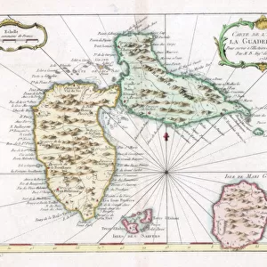
Photographic Print : Map of County Dublin, Ireland, 1924-1926


![]()
Photo Prints from Heritage Images
Map of County Dublin, Ireland, 1924-1926
Map of County Dublin, Ireland, 1924-1926. A print from Hutchinsons Britain Beautiful, edited by Walter Hutchinson, volume II, 1924-1926
Heritage Images features heritage image collections
Media ID 14943698
© The Print Collector / Heritage-Images
Cartography County County Dublin Dublin Ireland Irish Map Making Print Collector8
10"x8" Photo Print
Step back in time with our exquisite selection of vintage photographic prints from Media Storehouse. This particular print showcases a beautifully detailed map of County Dublin, Ireland, from the Hutchinsons Britain Beautiful series, edited by Walter Hutchinson, published in 1924-1926. Capture a piece of history with this intriguing and unique representation of County Dublin during the 1920s. Perfect for those with Irish heritage, history enthusiasts, or anyone looking to add a touch of nostalgia to their space.
Photo prints are produced on Kodak professional photo paper resulting in timeless and breath-taking prints which are also ideal for framing. The colors produced are rich and vivid, with accurate blacks and pristine whites, resulting in prints that are truly timeless and magnificent. Whether you're looking to display your prints in your home, office, or gallery, our range of photographic prints are sure to impress. Dimensions refers to the size of the paper in inches.
Our Photo Prints are in a large range of sizes and are printed on Archival Quality Paper for excellent colour reproduction and longevity. They are ideal for framing (our Framed Prints use these) at a reasonable cost. Alternatives include cheaper Poster Prints and higher quality Fine Art Paper, the choice of which is largely dependant on your budget.
Estimated Image Size (if not cropped) is 18.4cm x 25.4cm (7.2" x 10")
Estimated Product Size is 20.3cm x 25.4cm (8" x 10")
These are individually made so all sizes are approximate
Artwork printed orientated as per the preview above, with portrait (vertical) orientation to match the source image.
FEATURES IN THESE COLLECTIONS
> Europe
> Republic of Ireland
> Dublin
> Europe
> Republic of Ireland
> Maps
> Maps and Charts
> Related Images
EDITORS COMMENTS
This print takes us back in time to the early 1920s, offering a glimpse into the geography of County Dublin, Ireland. The map, originally featured in Hutchinsons Britain Beautiful, edited by Walter Hutchinson, is a testament to the meticulous artistry of cartography during this era. As we study this monochrome masterpiece, we are transported to an age where map making was both an art form and a scientific endeavor. Every contour line and intricate detail on this map serves as a reminder of the dedication and skill required to accurately represent the landscape. County Dublin unfolds before our eyes with its charming towns and villages nestled amidst rolling hills and winding rivers. This snapshot from history allows us to appreciate how much has changed over the past century while also recognizing that some elements remain timeless. The unknown creator behind this work deserves recognition for their contribution to preserving Irish heritage through cartography. Their attention to detail brings life to every corner of County Dublin, inviting viewers on a journey through time. Whether you have personal ties to Ireland or simply appreciate historical artifacts like maps, this print is sure to captivate your imagination. It serves as a visual portal connecting us with generations past while reminding us of the enduring beauty found within County Dublin's borders.
MADE IN THE USA
Safe Shipping with 30 Day Money Back Guarantee
FREE PERSONALISATION*
We are proud to offer a range of customisation features including Personalised Captions, Color Filters and Picture Zoom Tools
FREE COLORIZATION SERVICE
You can choose advanced AI Colorization for this picture at no extra charge!
SECURE PAYMENTS
We happily accept a wide range of payment options so you can pay for the things you need in the way that is most convenient for you
* Options may vary by product and licensing agreement. Zoomed Pictures can be adjusted in the Cart.