Photographic Print > Europe > United Kingdom > England > London > Art > Theatre
Photographic Print : Map illustrating the Campaigns in Egypt from February, 1915, to May, 1916, . Creator: Unknown


![]()
Photo Prints from Heritage Images
Map illustrating the Campaigns in Egypt from February, 1915, to May, 1916, . Creator: Unknown
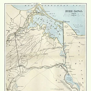
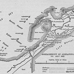
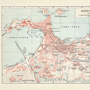
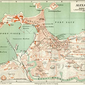
Map illustrating the Campaigns in Egypt from February, 1915, to May, 1916, (c1920). Alexandria and the Nile delta, Cairo, Port Said, the Suez Canal and the Sinai Peninsula during the First World War. From " The Great World War: A History", Volume V, edited by Frank A Mumby. [The Gresham Publishing Company Ltd, London, c1920]
Heritage Images features heritage image collections
Media ID 19665751
© The Print Collector/Heritage Images
Alexandria Alexandria Egypt Cairo Cairo Egypt Canal Frank A Frank A Mumby Frank Arthur Frank Arthur Mumby Gresham Publishing Co Ltd Gresham Publishing Company Keystone Archives Mediterranean Sea Mumby Mumby Frank A Mumby Frank Arthur Nile Nile Delta North Africa Ottoman Empire Port Said River Nile Sinai Sinai Egypt Sinai Peninsula Suez Canal The Great World War A History The Nile Theatre Of War
11"x8.5" Photo Print
Step back in time with our exclusive Media Storehouse range of historical photographic prints. This captivating map, sourced from Heritage Images, illustrates the pivotal campaigns in Egypt during the First World War, from February 1915 to May 1916. Featuring key locations such as Alexandria, Cairo, Port Said, the Suez Canal, and the Sinai Peninsula, this map offers a unique perspective on the strategic importance of Egypt during this period. With intricate detail and a vintage aesthetic, this print is a must-have for history enthusiasts and collectors alike. Please note, the creator and date of the original map are unknown.
Photo prints are produced on Kodak professional photo paper resulting in timeless and breath-taking prints which are also ideal for framing. The colors produced are rich and vivid, with accurate blacks and pristine whites, resulting in prints that are truly timeless and magnificent. Whether you're looking to display your prints in your home, office, or gallery, our range of photographic prints are sure to impress. Dimensions refers to the size of the paper in inches.
Our Photo Prints are in a large range of sizes and are printed on Archival Quality Paper for excellent colour reproduction and longevity. They are ideal for framing (our Framed Prints use these) at a reasonable cost. Alternatives include cheaper Poster Prints and higher quality Fine Art Paper, the choice of which is largely dependant on your budget.
Estimated Image Size (if not cropped) is 27.9cm x 14.7cm (11" x 5.8")
Estimated Product Size is 27.9cm x 21.6cm (11" x 8.5")
These are individually made so all sizes are approximate
Artwork printed orientated as per the preview above, with landscape (horizontal) orientation to match the source image.
FEATURES IN THESE COLLECTIONS
> Africa
> Egypt
> Alexandria
> Africa
> Egypt
> Related Images
> Africa
> Related Images
> Animals
> Mammals
> Muridae
> Water Mouse
> Arts
> Landscape paintings
> Waterfall and river artworks
> River artworks
> Europe
> United Kingdom
> England
> London
> Art
> Theatre
Map illustrating the Campaigns in Egypt from February, 1915, to May, 1916
EDITORS COMMENTS
. This print takes us back to the turbulent times of the First World War. The map showcases a crucial theater of war - Egypt - during the period between February 1915 and May 1916. Created by an unknown artist and featured in "The Great World War: A History" this historical artifact offers a glimpse into the strategic importance of Alexandria and its surrounding regions. The intricate details on this map highlight key geographical features such as Cairo, Port Said, the Suez Canal, and the Sinai Peninsula. These locations played vital roles in transportation routes for both sides involved in the conflict. As we observe this piece closely, it becomes evident that it was meticulously crafted to aid military planning during those challenging times. The image also reminds us of Egypt's significant position within the vast Ottoman Empire at that time. The Nile River dominates much of this map, symbolizing lifeblood amidst chaos. It serves as a reminder that even amid war-torn landscapes, nature continues to flow steadily. As we reflect on this photograph print from Heritage Images' collection curated by Frank A Mumby for Gresham Publishing Company Ltd. , let us appreciate how history unfolds through maps like these – capturing moments frozen in time while offering valuable insights into past conflicts and their impact on nations worldwide.
MADE IN THE USA
Safe Shipping with 30 Day Money Back Guarantee
FREE PERSONALISATION*
We are proud to offer a range of customisation features including Personalised Captions, Color Filters and Picture Zoom Tools
SECURE PAYMENTS
We happily accept a wide range of payment options so you can pay for the things you need in the way that is most convenient for you
* Options may vary by product and licensing agreement. Zoomed Pictures can be adjusted in the Cart.