Photographic Print > Animals > Mammals > Cats (Domestic) > Russian White
Photographic Print : Russiae, Moskoviae et Tartariae descriptio, 1562. Creator: Anthony Jenkinson


![]()
Photo Prints from Heritage Images
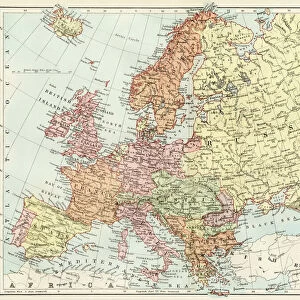
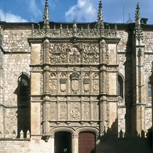
Russiae, Moskoviae et Tartariae descriptio, 1562. Creator: Anthony Jenkinson
Russiae, Moskoviae et Tartariae descriptio, 1562. No. 1 Karta iz izdaniia: Atlas Aziatskoi Rossii.- SPb. Pereselencheskoe Upravlenie, kartogr. art. Zav. A.F. Marks, 1914. Za ramkoi karty perevody nadpisei na karte Otpechatano v Kartograficheskom zavedenii Iu. Iu. Gash. Kopiias karty Dzhenkinsona, izdannoi V.Kordtom
Heritage Images features heritage image collections
Media ID 35128361
© Heritage Art/Heritage Images
1560s Atlas Cartographic Cartography Federation Latin Map Making Mapmaking Moscow Russia Meeting Of Frontiers Pictorial Map
10"x8" Photo Print
Step back in time with our exquisite offering from the Media Storehouse range of Historical Photographic Prints. This rare and captivating image, "Russiae, Moskoviae et Tartariae descriptio," created by Anthony Jenkinson in 1562, provides a fascinating glimpse into the past. With intricate details and vibrant colors, this antique map of Russia, Moscovia, and Tartaria offers a unique perspective on the geography and political landscape of the time. Printed from the 1914 edition, this photographic print is a must-have for history enthusiasts, cartography collectors, and anyone seeking to adorn their walls with a piece of historical significance. Experience the rich history of the past through our high-quality, museum-grade prints.
Photo prints are produced on Kodak professional photo paper resulting in timeless and breath-taking prints which are also ideal for framing. The colors produced are rich and vivid, with accurate blacks and pristine whites, resulting in prints that are truly timeless and magnificent. Whether you're looking to display your prints in your home, office, or gallery, our range of photographic prints are sure to impress. Dimensions refers to the size of the paper in inches.
Our Photo Prints are in a large range of sizes and are printed on Archival Quality Paper for excellent colour reproduction and longevity. They are ideal for framing (our Framed Prints use these) at a reasonable cost. Alternatives include cheaper Poster Prints and higher quality Fine Art Paper, the choice of which is largely dependant on your budget.
Estimated Image Size (if not cropped) is 25.4cm x 18.6cm (10" x 7.3")
Estimated Product Size is 25.4cm x 20.3cm (10" x 8")
These are individually made so all sizes are approximate
Artwork printed orientated as per the preview above, with landscape (horizontal) orientation to match the source image.
FEATURES IN THESE COLLECTIONS
> Animals
> Mammals
> Cats (Domestic)
> Russian White
> Arts
> Art Movements
> Renaissance Art
> Maps and Charts
> Early Maps
> Maps and Charts
> Related Images
EDITORS COMMENTS
Anthony Jenkinson's Russiae, Moskoviae et Tartariae descriptio, created in the 1560s, is a rare and intriguing glimpse into the geographical knowledge of the Russian lands during the Renaissance. This black and white, pictorial map is a copy from the atlas "Atlas Aziatskoi Rossii," published in St. Petersburg in the 1910s. The original map was printed in the cartographic workshop of Ivan Y. Gashek. Jenkinson, an English merchant and explorer, traveled extensively in Russia and the surrounding regions during the mid-16th century. His map reflects the limited knowledge of the time, with inaccuracies and misconceptions common in cartography of the era. The map is divided into three parts: Russia, Moskovia, and Tartaria. The map includes various geographical features, such as rivers, mountains, and cities, as well as figures of animals, including bears, elk, and deer. The map's lettering is in Latin, with the title "Russiae, Moscoviae et Tartariae Descriptio" encircling the border. The map's central location is the meeting of the frontiers of Russia, Moskovia, and Tartaria, with Moscow at the heart of the map. The map's historical significance lies in its contribution to the early cartographic record of Russia and the surrounding regions. Today, this precious map is part of the Library of Congress's collections, a testament to the rich heritage of cartography and the exploration of the world during the Renaissance.
MADE IN THE USA
Safe Shipping with 30 Day Money Back Guarantee
FREE PERSONALISATION*
We are proud to offer a range of customisation features including Personalised Captions, Color Filters and Picture Zoom Tools
FREE COLORIZATION SERVICE
You can choose advanced AI Colorization for this picture at no extra charge!
SECURE PAYMENTS
We happily accept a wide range of payment options so you can pay for the things you need in the way that is most convenient for you
* Options may vary by product and licensing agreement. Zoomed Pictures can be adjusted in the Cart.